Carabost is a foresting community in the south-east part of the Riverina. It is situated about 16 kilometres north west of Rosewood and 22 kilometres south east of Kyeamba.
Carabost can be found on the Tumbarumba Road near the location of the Carabost National Forest - a large PinePlantation in the area. The only facilities available in the area, other than the Carabost Town Hall built in 1927, and a Fire Brigade Shed, is a public telephone box and a post box - both at the same location as the district emergency gathering point which is used in the case of forest fire or similar emergency.
Carabost is the Gaelic form of Carbost on the Scottish island of Skye and means Copse farm.[2]
Carabost Post Office opened on 1March 1879, and it closed on 4 March 1897. It then reopened on 1 January 1915 and was closed once again on 27 January 1968[3]
Gold was known to exist in the area, from at least the late 1880s,[4] but Carabost was not as well known for gold, as the neighbouring mining areas of Humula and Tumbarumba. During the 1920s, parts of the locality of Carabost were mined for gold by dredging.[5]
Climate
Located on the exposed western edge of the South West Slopes, Carabost experiences cool maximum temperatures relative to its altitude (particularly in winter), averaging just 9.1°C (48.4°F) in July.
Climate data for Carabost Forest Headquarters (1938–1969); 580 m AMSL; 35.65° S, 147.80° E
Harden–Murrumburrah is a township and community in the Hilltops Region and is located in the South West Slopes of New South Wales in Australia and is adjacent to both the Canberra region of the Australian Capital Territory and the Riverina Region in the southwest area of NSW. The town is a twin town between Harden and Murrumburrah.
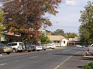
Tumbarumba is a small town in New South Wales, Australia, about 480 kilometres (300 mi) southwest of the state capital, Sydney. Tumbarumba is located on the periphery of the Riverina and South West Slopes regions at the western edge of the Snowy Mountains. The 2016 census showed the population of the town and surrounding area to be 1,862 people. Locals refer to the town as 'Tumba'.
Tarcutta is a town in south-western New South Wales, Australia. The town is 438 kilometres (272 mi) south-west of Sydney, 3 kilometres (1.9 mi) east of the Hume Highway, It was proclaimed as a village on 28 October 1890. As of 2016, the town had a population of 446.
Gerogery is a town established on Wiradjuri land in the Riverina region of the Australian state of New South Wales. The town is in the Greater Hume Shire local government area and on the Main South railway line between Sydney and Melbourne, where it intersects with the Olympic Highway. Gerogery serves a rural farming community. Gerogery has a temperate climate. It lies close to the Great Yambla Range, with its striking Tabletop and Sugar Loaf ridge at the southern end.
Humula is a small country town between Tarcutta and Tumbarumba in New South Wales, Australia. Humula was once named "American Yards" or "American Fields" during the gold rush, where many Chinese came for gold years ago. At the 2016 census, Humula had a population of 124 people.
Wagga Wagga railway station is a railway station open for passenger services on the Main South line connecting Sydney and Melbourne. It has been heritage-listed, especially on account of its historical and architectural significance. A museum is on the premises. As of 2021, two daily passenger trains in each direction served the City of Wagga Wagga.
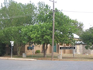
Mangoplah is a town approximately 36 kilometres (22 mi) south of Wagga Wagga in the Riverina region of New South Wales, Australia. At the 2016 census, Mangoplah had a population of 309. The name of the town is believed to mean "Kooris singing" in the Wiradjuri aboriginal language.
The South Western Slopes, also known as the South West Slopes, is a region predominantly in New South Wales, Australia. It covers the lower inland slopes of the Great Dividing Range extending from north of Cowra through southern NSW into western Victoria. More than 90% of the region is in the state of New South Wales and it occupies about 10% of that state.
Batlow is a town in the South West Slopes region of New South Wales, Australia, on the edge of the Great Dividing Range, 775 m above sea level.
The Main Southern Railway is a major railway in New South Wales, Australia. It runs from Sydney to Albury, near the Victorian border. The line passes through the Southern Highlands, Southern Tablelands, South West Slopes and Riverina regions.
Boree Creek is a town in the Riverina district of New South Wales, Australia. The town is located 539 kilometres (335 mi) south west of the state capital, Sydney and 82 kilometres (51 mi) west of the regional centre, Wagga Wagga. Boree Creek is situated in the Federation Council local government area but is closer to the town of Lockhart. At the 2016 census, Boree Creek had a population of 64.
Downside is a farming community in the central east part of the Riverina and situated about 15 kilometres north west from Wagga Wagga and 24 kilometres south east from Coolamon.
Grahamstown is a village community in the central east part of the Riverina and situated about 12 kilometres north of Adelong and 13 kilometres south of Tumblong. At the 2016 census, Grahamstown had a population of 61 people.
Tooma is a locality and village community in the Snowy Valleys Council local government area, in the eastern part of the Riverina region of New South Wales.
Rosewood is a village community and locality in the south east part of the Riverina, New South Wales, Australia. It is situated about 16 kilometres (9.9 mi) south east from Carabost and 19 kilometres (12 mi) north west from Tumbarumba. At the 2016 census, Rosewood had a population of 214. The village is administered by two local governments; the northern part of the locality by the Greater Hume Shire and the southern part of the locality by the Snowy Valleys Council. The village of Rosewood is within the Snowy Valleys Council area.
Laurel Hill is a village community in the south east part of the Riverina, in New South Wales, Australia. It is situated by road, about 14 kilometres south of Batlow and 22 kilometres north of Tumbarumba.
Urangeline is a village community in the central part of the Riverina. It is situated by road, about 9 kilometres north from Urangeline East and 16 kilometres north east from Bidgeemia.
Osborne is a village community in the central east part of the Riverina. It is situated by road, about 15 kilometres south from Lockhart and 19 kilometres west from Woodend.
The Tumbarumba railway line is a railway line in New South Wales, Australia. Proposals were commenced back as early as 1881. The length of an initial proposal showed it to be 74 miles 64 chains (120.4 km) in length. The final built length being 80 miles (129 km).
A bushfire season occurred predominantly from June 2009 to May 2010. Increased attention has been given to this season as authorities and government attempt to preempt any future loss of life after the Black Saturday bushfires during the previous season, 2008–09. Long range weather observations predict very hot, dry and windy weather conditions during the summer months, leading to a high risk of bushfire occurrence.
This page is based on this Wikipedia article Text is available under the CC BY-SA 4.0 license; additional terms may apply. Images, videos and audio are available under their respective licenses.