
Hay is a town in the western Riverina region of south western New South Wales, Australia. It is the administrative centre of Hay Shire local government area and the centre of a prosperous and productive agricultural district on the wide Hay Plains.

The Riverina is an agricultural region of south-western New South Wales, Australia. The Riverina is distinguished from other Australian regions by the combination of flat plains, warm to hot climate and an ample supply of water for irrigation. This combination has allowed the Riverina to develop into one of the most productive and agriculturally diverse areas of Australia. Bordered on the south by the state of Victoria and on the east by the Great Dividing Range, the Riverina covers those areas of New South Wales in the Murray and Murrumbidgee drainage zones to their confluence in the west.

Hillston is a township in western New South Wales, Australia, in Carrathool Shire, on the banks of the Lachlan River. It was founded in 1863 and at the 2016 census had a population of 1,465.

Conargo is a town in the Riverina region of New South Wales, Australia. The town is in the Edward River Council local government area. It is on the Billabong Creek, a tributary of the Murrumbidgee River. The nearest towns are Jerilderie and Deniliquin. At the 2006 census, Conargo had a population of 188 people.

Darlington Point is a small town on the banks of the Murrumbidgee River in the Riverina district of western New South Wales, Australia. It is part of the Murrumbidgee Council local government area. The centre of town is four kilometres from the Sturt Highway, along Kidman Way. Darlington Point is 631 kilometres (392 mi) south-west of Sydney and 33 kilometres (21 mi) south of Griffith. At the 2011 census, Darlington Point had a population of 1,016.

Moulamein is a small town in New South Wales, Australia, in the Murray River Council local government area. At the 2011 census, Moulamein had a population of 330. Moulamein is the oldest town in the Riverina.

Mount Hope is a settlement in western New South Wales, Australia. It is situated on the Kidman Way, 95 kilometres north of Hillston and 160 km south of Cobar. A government township called 'Nombinnie' was surveyed in the mid-1880s but that name was rarely used.

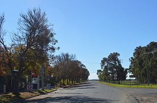
Mathoura is a small town in the Riverina region of southern New South Wales, Australia, in the Murray River Council local government area. At the 2016 census, Mathoura had a population of 938. The town's name is derived from an aboriginal word for 'windy'.

Rankins Springs is a village in the Riverina region of New South Wales, Australia in Carrathool Shire and on the Mid-Western Highway. At the 2011 census, Rankins Springs had a population of 299 residents living in 145 private dwellings. The settlement is strung out along the Mid-Western Highway and adjacent railway line. The main agricultural activities of the district around Rankins Springs are the growing of crops such as wheat and oats, and beef-cattle and wool-production.

Booligal is a village in the Riverina area of western New South Wales (NSW), Australia. It is located on the Cobb Highway, on the Lachlan River north of Hay. Booligal is a part of Hay Shire local government area.
Maude is a village on the north bank of the Murrumbidgee River in New South Wales, Australia. It is in between Hay and Balranald in Hay Shire. It is located 55 kilometres downstream from Hay and 25 kilometres upstream from the junction of the Lachlan River with the Murrumbidgee. At the 2006 census, Maude had a population of 161 people. Maude consists of a General Store, hotel, post office and caravan park. The town is surrounded by market gardens supplied with water from Maude Weir, a popular spot for anglers, looking for yellow belly, redfin and Murray cod.

Cookardinia is a rural locality in the Riverina region of New South Wales, Australia. The locality is 57 kilometres (35 mi) south of the regional city of Wagga Wagga and 24 kilometres (15 mi) east of the town of Henty. Its surrounding area has an approximate population of 283 persons.

Booroorban is a locality in the central part of the Riverina. It is in the Edward River Council local government area and on the Cobb Highway between Hay and Deniliquin, around 769 kilometres (478 mi) south west of the state capital, Sydney. At the 2016 census, Booroorban had a population of 33.

Oxley is a community on the lower Lachlan River in the Riverina district of New South Wales, Australia near the junction of the Lachlan and Murrumbidgee Rivers. The township which developed in the mid-1860s was named after the noted Australian explorer, John Oxley. At the 2006 census, Oxley had a population of 159 people.
Mossgiel is a location in New South Wales, Australia, in Carrathool Shire. It was a township on the coach route between the Lachlan and Darling Rivers, 50 km southeast of Ivanhoe near the junction with the road to Hillston. The settlement experienced a steady decline during the 20th century. Nowadays Mossgiel township consists of one house and a community hall.
Hay and Hell and Booligal is a poem by the Australian bush poet A. B. 'Banjo' Paterson who wrote the poem while working as a solicitor with the firm of Street & Paterson in Sydney. It was first published in The Bulletin on 25 April 1896. The poem was later included in Paterson's collection Rio Grande's Last Race and Other Verses, first published in 1902.

Deniliquin, known locally as "Deni", is a town in the Riverina region of New South Wales, Australia, close to the border with Victoria. It is the largest town in the Edward River Council local government area.
The Hay Standard was an English language newspaper published in Hay, New South Wales, from 1871 to 1900. It was the first newspaper published at Hay.

Yandumblin is a rural locality of Hay Shire Council and a civil parish of Nicholson County, in the Riverina region of Australia.

Mulwala Homestead is a heritage-listed homestead at North Road, Mulwala, New South Wales, Australia. It was added to the Australian Commonwealth Heritage List on 22 June 2004.


