
The Numeralla River, a perennial river that is part of the Murrumbidgee catchment within the Murray–Darling basin, is located in the Monaro region of New South Wales, Australia.

Bowna is a locality in the South East part of the Riverina, New South Wales, Australia.
Langtree is a rural locality and the site of a discontinued railway station in the central northern part of the Riverina. The railway station was about 8 kilometres north of Goorawin and 22 kilometres south of Hillston.
Pulletop is a rural locality in the south eastern part of the Riverina - it used to be called Pullitop. It is situated by road, about 5 kilometres east south-east of Burrandana and 9 kilometres north of Westby.

Burrandana is a rural locality in the south eastern part of the Riverina. It is situated by road, about five kilometres (3.1 mi) east south-east of Pulletop and nine kilometres (5.6 mi) north of Mangoplah.

Nicholson County is one of the 141 Cadastral divisions of New South Wales. It contains the towns of Hillston, Goolgowi, Gunbar, Merriwagga, Goorawin and Langtree. The Lachlan River is its north-western boundary.
The Bemboka River, a perennial stream of the Bega River catchment, is located in the Monaro and South Coast regions of New South Wales, Australia.
The Boomi River, an anabranch of the Barwon River and part of the Macintyre catchment within the Murray–Darling basin, is located in the north–western slopes region of New South Wales, flowing downstream into the South Downs region of Queensland, Australia.

Boorowa River, a perennial stream that is part of the Lachlan catchment within the Murray–Darling basin, is located in the central–western region of New South Wales, Australia.
The Coolumbooka River, a perennial river of the Snowy River catchment, is located in the Monaro region of New South Wales, Australia.
The Tarcutta Creek, part of the Murray Darling basin, is mostly a perennial stream located in the Riverina region of New South Wales, Australia.
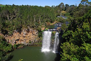
Bielsdown River, a perennial stream that is part of the Clarence River catchment, is located in the Northern Tablelands of New South Wales, Australia.
Bettowynd Creek, a partly perennial stream of the Moruya River catchment, is located in the Southern Tablelands and South Coast regions of New South Wales, Australia.
The Sandy Creek, a perennial stream of the Richmond River catchment, is located in Northern Rivers region in the state of New South Wales, Australia.
The Shannon Brook, a perennial stream of the Richmond River catchment, is located in Northern Rivers region in the state of New South Wales, Australia.
The Clouds Creek, a perennial stream that is part of the Clarence River catchment, is located in the Northern Tablelands region of New South Wales, Australia.
The Cullinga Creek, a mostly–perennial river that is part of the Murrumbidgee catchment within the Murray–Darling basin, is located in the South West Slopes region of New South Wales, Australia.
The Sandy Creek, a partly–perennial stream that is part of the Lachlan sub-catchment of the Murrumbidgee catchment within the Murray–Darling basin, is located in the Riverina region of New South Wales, Australia. The course of the Sandy Creek becomes indefinite at its mouth.
The River Pocwock is a tributary of the Saint John River, flowing in:
The West Branch Pocwock Stream is a tributary of the Pocwock River flowing in:
This page is based on this
Wikipedia article Text is available under the
CC BY-SA 4.0 license; additional terms may apply.
Images, videos and audio are available under their respective licenses.
