
Strathmerton is a small country town in Victoria, Australia.

Yarrawonga is a town in the Shire of Moira local government area in the Australian state of Victoria. The town is situated on the south bank of the Murray River, the border between Victoria and New South Wales and is located approximately 265 kilometres (165 mi) north-east of the state capital, Melbourne. Yarrawonga's twin town of Mulwala is on the other side of the Murray River. At the 2016 census, Yarrawonga had a population of 7,930.

Katunga is a town in the Goulburn Valley region of northern Victoria, Australia. The town is located in the Shire of Moira local government area, 228 kilometres from the state capital, Melbourne. At the 2016 census, Katunga had a population of 996.
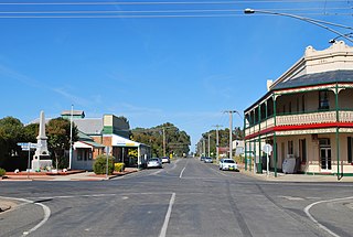
Tungamah is a town in the Goulburn Valley region of northern Victoria, Australia. The town is located in the Shire of Moira local government area, 259 kilometres (161 mi) from the state capital, Melbourne. Tungamah is situated on the banks of Boosey Creek and at the 2006 census, Tungamah had a population of 355..

Wunghnu is a small town in the Goulburn Valley region of northern Victoria, Australia. The town is located in the Shire of Moira local government area, 204 kilometres (127 mi) north of the state capital, Melbourne. The local railway station was opened on the Goulburn Valley railway in 1881, but does not see any passenger services, being the site of a siding and grain silos.

Ournie is a rural community in the far south east part of the Riverina and situated about 15 kilometres north west from Welaregang and 20 kilometres south from Munderoo. Ournie is situated on the banks of the Ournie Creek which flows into the Murray River and the area is only about 4 kilometres from the border of Victoria.
Yarroweyah is a town in northern Victoria, Australia. The town is located in the Shire of Moira local government area, 251 kilometres (156 mi) north of the state capital, Melbourne and 10 kilometres (6 mi) west of Cobram. The town is situated near the intersection of Kenny Road, Kokoda Road and the Murray Valley Highway. At the 2011 census, Yarroweyah and the surrounding area had a population of 528.

Waaia is a town in northern Victoria, Australia in the Shire of Moira local government area, 228 kilometres (142 mi) north of the state capital, Melbourne. The area is home to mainly irrigated dairy farms. At the 2011 census, Waaia and the surrounding area had a population of 376.

St James is a town in northern Victoria, Australia. The town is located in the Shire of Moira local government area, 238 kilometres (148 mi) north of the state capital, Melbourne. At the 2016 census, St James had a population of 132.

Bearii is a small settlement in Victoria, Australia. The town is in the Shire of Moira local government area. Bearii is located 252 kilometres (157 mi) north of the state capital, Melbourne, 18 kilometres (11 mi) north of Waaia and is just south of the Barmah National Park. At the 2011 census, Bearii had a population of 136, by 2016 the town had 145 citizens.

Koonoomoo is a town in northern Victoria, Australia. The town is located in the Shire of Moira local government area, 264 kilometres (164 mi) north of the state capital, Melbourne on the Goulburn Valley Highway, near the Murray River. At the 2011 census, Koonoomoo had a population of 255.

Peechelba is a small town in north eastern Victoria, Australia. The town is located in the Rural City of Wangaratta and the Shire of Moira local government area between Wangaratta and Yarrawonga and 277 kilometres (172 mi) north west of the state capital, Melbourne. At the 2011 census, Peechelba and the surrounding area had a population of 345. The town is home to a nature reserve, not far from the Ovens River.

The Shire of Nathalia was a local government area on the Murray River in the Goulburn Valley region about 220 kilometres (137 mi) north of Melbourne, the state capital of Victoria, Australia. The shire covered an area of 1,238.97 square kilometres (478.4 sq mi), and existed from 1879 until 1994.

The Shire of Numurkah was a local government area on the Murray River in the Goulburn Valley region about 210 kilometres (130 mi) north of Melbourne, the state capital of Victoria, Australia. The shire covered an area of 820 square kilometres (316.6 sq mi), and existed from 1957 until 1994.
Lower Moira is a locality in northern Victoria, Australia. The locality is in the south-west part of Shire of Moira. Lower Moira is mostly farmland. To the west is the New South Wales border.
Kaarimba, also unofficially known as Karimba, is a small locality in Victoria, Australia in the local government area of the Shire of Moira.

Marungi is a locality in northern Victoria. The locality is shared between the local government areas of the Shire of Moira and City of Greater Shepparton.
Yabba South is a locality in Victoria, Australia. The locality is in the southern part of the Shire of Moira. The former Katamatite Tramway ran through Yabba South.
Burramine South is a locality in the Shire of Moira. Burramine South post office opened on 1 February 1882, closed on 17 December 1910, reopened on the 19 September 1911 and closed on 1 August 1952. Burramine South Creamery post office opened on the 1 July 1905 and was closed on 1 January 1918.
Bundalong South is a locality in the Shire of Moira local government area. The post office opened as Peechelba on 2 September 1880 and was renamed Bundalong South on 2 July 1883. It closed on 31 March 1966.


