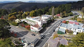
Katoomba is the chief town of the City of Blue Mountains in New South Wales, Australia, and the administrative headquarters of Blue Mountains City Council. Katoomba is located on the lands of the Dharug and Gundungurra Aboriginal peoples.
Goulburn is a regional city in the Southern Tablelands of New South Wales, Australia, approximately 195 kilometres (121 mi) south-west of Sydney and 90 kilometres (56 mi) north-east of Canberra. It was proclaimed as Australia's first inland city through letters patent by Queen Victoria in 1863. Goulburn had a population of 24,565 at June 2021. Goulburn is the seat of Goulburn Mulwaree Council.

Molong is a small town in the Central West region of New South Wales, Australia, in Cabonne Shire.

Nyngan is a town in the centre of New South Wales, Australia, in the Bogan Shire local government area within the Orana Region of central New South Wales. At the 2016 census, Nyngan had a population of 1,988 people. Nyngan is situated on the Bogan River between Narromine and Bourke, on the junction of the Mitchell Highway and Barrier Highway, 656 km (408 mi) south of Charleville and 576 km (358 mi) north-west of Sydney by road. The Barrier Highway starts at Nyngan, and runs west to Cobar and on through Wilcannia and Broken Hill into South Australia.

Tocumwal is a town in the southern Riverina region of New South Wales, Australia, in the Berrigan Shire local government area. The town, 270 kilometres (170 mi) north of the city of Melbourne, lies on the northern bank of the Murray River, which forms the border with Victoria.

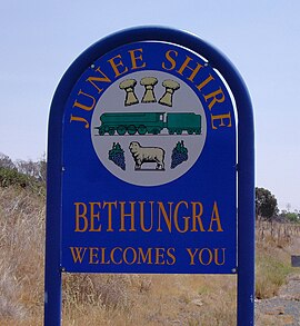
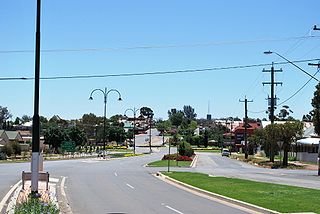
Junee is a medium-sized town in the Riverina region of New South Wales, Australia. The town's prosperity and mixed services economy is based on a combination of agriculture, rail transport, light industry and government services, and in particular correctional services. In 2015 Junee's urban population was 4,762.
Medlow Bath is a village located near the highest point of the Blue Mountains, New South Wales, Australia. Located between Katoomba and Blackheath, its altitude is about 1,050 metres (3,440 ft) AHD . It is about 115 kilometres (71 mi) west-north-west of the Sydney central business district and 5 kilometres (3.1 mi) north-west of Katoomba. At the 2016 census, Medlow Bath had a population of 611 people.

Canterbury is a suburb of western Sydney, in the state of New South Wales, Australia. Canterbury is located 10.5 kilometres (6.5 mi) south-west of the Sydney central business district in the City of Canterbury-Bankstown.

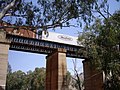
The Bethungra Spiral is a heritage-listed rail spiral on the Main Southern line near Bethungra, between Junee and Cootamundra. The spiral carries the northbound track, forming a part of the Sydney–Melbourne rail corridor.

The City of Blue Mountains is a local government area of New South Wales, Australia, governed by the Blue Mountains City Council. The city is located in the Blue Mountains, on the Great Dividing Range at the far western fringe of the Greater Sydney area. Major settlements include, Katoomba, Lawson, Springwood and Blaxland.
Mount Victoria is a village in the Blue Mountains of New South Wales, Australia. Mount Victoria is geographically the western most village and suburb of Greater Sydney on the great western highway in the City of Blue Mountains, located about 120 kilometres (75 mi) west-northwest by road from the Sydney central business district and at an altitude of about 1,052 metres (3,451 ft) AHD . The settlement had a population of 823 people at the 2011 Census.

Grong Grong is a small town that is located in the Riverina region of New South Wales, Australia. The town is situated on the Newell Highway, 23 kilometres (14 mi) east of Narrandera in the Shire of Narrandera.
Coolamon is a town in the Riverina region of south-west New South Wales, Australia. Coolamon is 40 kilometres (25 mi) north-west of Wagga Wagga and 506 kilometres (314 mi) south-west of Sydney via the Hume and Sturt Highways. The town is situated on the railway line between Junee and Narrandera. Coolamon had a population of 2,275 at the 2021 census and is 290 metres (950 ft) above sea level. It is the administrative and service centre for the local government area which bears its name—Coolamon Shire.

Picton is a small town in the Macarthur Region of New South Wales, Australia, in the Wollondilly Shire, in south-western Sydney. The town is located approximately 90 kilometres south-west of the Sydney CBD, close to Camden and Campbelltown. It is also the administrative centre of Wollondilly Shire.

Bowning is a small town in the South West Slopes, 14 kilometres (8.7 mi) west of Yass on the Hume Highway in Yass Valley Shire. Bowning is an aboriginal word meaning 'big hill'. At the 2016 census, Bowning and the surrounding area had a population of 573.

Walcha Road is a rural village with a population of about 20, located 19 kilometres (12 mi) west of Walcha in the Northern Tablelands of New South Wales, Australia.

Wakool is a town in the western Murray region of New South Wales, Australia. Wakool is in the Murray River Council local government area, 791 kilometres (492 mi) south west of the state capital, Sydney and 336 kilometres (209 mi) north-west of Melbourne. At the 2016 census, Wakool had a population of 297.
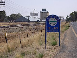
Illabo is a locality in the South West Slopes part of the Riverina in New South Wales, Australia. It is situated about 13 kilometres (8 mi) southwest of Bethungra and 16 kilometres (10 mi) northeast of Junee. At the 2016 census, Illabo had a population of 144.

Cootamundra railway station is located on the Main Southern line in New South Wales, Australia. It serves the town of Cootamundra. The property was added to the New South Wales State Heritage Register on 2 April 1999.

The Dubbo Regional Council is a local government area located in the Central West and Orana regions of New South Wales, Australia. The council was formed on 12 May 2016 through a merger of the City of Dubbo and Wellington Council as part of a widespread council amalgamation program. It was initially named Western Plains Regional Council for almost four months, and its name was changed to Dubbo Regional Council on 7 September 2016.