
Harden–Murrumburrah is a township and community in the Hilltops Region and is located in the South West Slopes of New South Wales in Australia. Harden is adjacent to both the Canberra region of the Australian Capital Territory and the Riverina Region in the southwest area of NSW. The town is a twin town between Harden and Murrumburrah.

Broadmeadows is a suburb in Melbourne, Victoria, Australia, 15 km (9.3 mi) north of Melbourne's Central Business District and the council seat of the City of Hume local government area. Broadmeadows recorded a population of 12,524 at the 2021 census. It is colloquially known as "Broady".

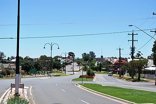
Temora is a town in the north-east of the Riverina area of New South Wales, 418 kilometres (260 mi) south-west of the state capital, Sydney. At the 2021 census the population of Temora was 4,016.

Urana is a small town in the Riverina region of New South Wales, Australia. The town is in the Federation Council local government area.
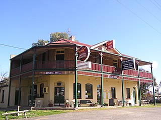
Coolac is a village in the Riverina region of New South Wales, Australia in Gundagai Council. At the 2021 census, Coolac had a population of 244.

Grong Grong is a small town that is located in the Riverina region of New South Wales, Australia. The town is situated on the Newell Highway, 23 kilometres (14 mi) east of Narrandera in the Shire of Narrandera.
Coolamon is a town in the Riverina region of south-west New South Wales, Australia. Coolamon is 40 kilometres (25 mi) north-west of Wagga Wagga and 506 kilometres (314 mi) south-west of Sydney via the Hume and Sturt Highways. The town is situated on the railway line between Junee and Narrandera. Coolamon had a population of 2,275 at the 2021 census and is 290 metres (950 ft) above sea level. It is the administrative and service centre for the local government area which bears its name—Coolamon Shire.

Brocklesby is a town in the Riverina region of south west New South Wales, Australia. The town is in the Greater Hume Shire Council local government area, 45 kilometres (28 mi) north-west of the regional centre of Albury. In the 2021 census Brocklesby had a population of 238.

Uranquinty is a small town approximately 15 kilometres (9 mi) south of Wagga Wagga, in the Riverina region of New South Wales, Australia. The population of the town, often referred to as "Quinty", is 909.

Collingullie is a village 26 kilometres (16 mi) north-west of Wagga Wagga in the Riverina region of New South Wales, Australia. The village is located on the Sturt Highway, between Wagga Wagga and Narrandera, at the crossroads with the road to Lockhart.
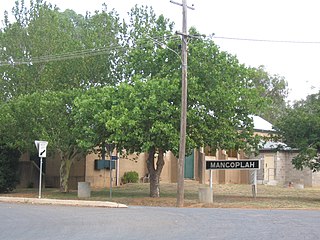
Mangoplah is a town approximately 36 kilometres (22 mi) south of Wagga Wagga in the Riverina region of New South Wales, Australia. At the 2016 census, Mangoplah had a population of 309. The name of the town is believed to mean "Kooris singing" in the Wiradjuri aboriginal language.
Little Wobby is a suburb of the Central Coast region of New South Wales, Australia, located on the north bank of the Hawkesbury River. It is part of the Central Coast Council local government area.

Boree Creek is a town in the Riverina district of New South Wales, Australia. The town is located 539 kilometres (335 mi) south west of the state capital, Sydney and 82 kilometres (51 mi) west of the regional centre, Wagga Wagga. Boree Creek is situated in the Federation Council local government area but is closer to the town of Lockhart. At the 2016 census, Boree Creek had a population of 64.

Ganmain is a town in the Riverina region of New South Wales, Australia. Ganmain is located around 55 kilometres (34 mi) north west of Wagga Wagga, and 50 kilometres (31 mi) east of Narrandera. Ganmain is in the Coolamon Shire local government area and had a population at the 2021 census of 793.

Binya is a farming community in the centre of the Riverina area of New South Wales, Australia. The village is situated about 30 kilometres (19 mi) east of Griffith along Burley Griffin Way, heading in the direction of Ardlethan.

Harefield is a locality in New South Wales, Australia. It in the central east part of the Riverina and situated about 11 kilometres south of Junee and 35 kilometres north by road from Wagga Wagga.
Urangeline is a village community in the central part of the Riverina. It is situated by road, about 9 kilometres north from Urangeline East and 16 kilometres north east from Bidgeemia.

Milbrulong is a locality in the central east part of the Riverina region of New South Wales, Australia.
The New South Wales Office of Sport, an agency of the New South Wales Government, is responsible for assisting the people of New South Wales to participate in sport and active recreation, in order to improve personal and community well being.
Kyeamba Shire was a local government area in the Riverina region of New South Wales, Australia.

