
The Pacific Highway is a 780-kilometre-long (485 mi) national highway and major transport route along the central east coast of Australia, with the majority of it being part of Australia's Highway 1. The highway and its adjoining Pacific Motorway between Brisbane and Brunswick Heads and Pacific Motorway between Sydney and Newcastle links the state capitals of Sydney in New South Wales with Brisbane in Queensland, approximately paralleling the Tasman Sea of the South Pacific Ocean coast, via Gosford, Newcastle, Taree, Port Macquarie, Kempsey, Coffs Harbour, Grafton, and Ballina. Additionally, between Brunswick Heads and Port Macquarie, the road is also signed as the Pacific Motorway, but has not been legally gazetted as such.

The Great Western Highway is a 201-kilometre-long (125 mi) state highway in New South Wales, Australia. From east to west, the highway links Sydney with Bathurst, on the state's Central Tablelands.

The Ryde Bridge(s), also called the Uhrs Point Bridge, are two road bridges that carry Concord Road, part of the A3, across Parramatta River from Ryde in the northern suburbs of Sydney to Rhodes in Sydney's inner west, in New South Wales, Australia.
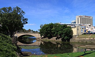
The Lennox Bridge is a heritage-listed sandstone single arch bridge across the Parramatta River, located in Parramatta in Western Sydney, New South Wales, Australia. The bridge was designed by and built under the supervision of David Lennox, the first Colonial Superintendent of Bridges using convict labour between 1836 and 1839. The Lennox Bridge is the third oldest surviving masonry bridge in New South Wales. The bridge carries Church Street, the main north-south street of Parramatta's central business district. It was added to the New South Wales State Heritage Register on 2 April 1999.

The Grafton Bridge is a heritage-listed bascule truss bridge that carries the Bent Street and North Coast railway line across the Clarence River in Grafton, New South Wales, Australia. The bridge links the Grafton central business district with South Grafton, and was added to the New South Wales State Heritage Register on 2 April 1999.

Dilpurra is a village community in the south western part of the Riverina in New South Wales, Australia.

Wakool is a town in the western Riverina region of New South Wales, Australia. Wakool is in the Murray River Council local government area, 791 kilometres (492 mi) south west of the state capital, Sydney and 336 kilometres (209 mi) north-west of Melbourne. At the 2016 census, Wakool had a population of 297.

Goodradigbee River, a perennial stream that is part of the Murrumbidgee catchment within the Murray–Darling basin, is located in the Snowy Mountains district of New South Wales, Australia.

Fullers Bridge, officially called the Fullers Creek Bridge, is a road bridge that carries Delhi Road to Millwood Avenue across the Lane Cove River, in Chatswood West, Sydney, New South Wales, Australia. The concrete beam bridge is located 9 kilometres (5.6 mi) northwest of the Sydney central business district and connects Chatswood to North Ryde as part of the A38.

The Harwood Bridge is a two-lane steel truss bridge which carried the Pacific Highway over the Clarence River in the Northern Rivers region of New South Wales, Australia from 1966 until 2019, when it was replaced by a four-lane 1.5-kilometre-long (4,921 ft) concrete bridge, located 20 metres (66 ft) to its east. The Harwood Bridge has been retained to provide access to Harwood Island.

The Peats Ferry Bridge is a steel truss bridge that carries the Pacific Highway (B83) across the Hawkesbury River, between Kangaroo Point and Mooney Mooney Point, located 40 kilometres (25 mi) north of Sydney in New South Wales, Australia. The bridge carries the Hornsby to Kariong section of highway, while the adjacent Brooklyn Bridge carries the Pacific Motorway (M1).

Wakool River, an anabranch of the Edward River that is part of the Murray River catchment within the Murray-Darling basin, is located in the western Riverina region of south western New South Wales, Australia.
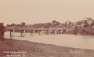
The Windsor Bridge, officially called the Hawkesbury River Bridge, Windsor, a beam bridge across the Hawkesbury River, is located in Windsor in north-western Sydney, New South Wales, Australia. The bridge was built in 1874. On 18 May 2020, the replacement bridge was opened to traffic within Windsor, NSW.

The Murray River Council is a local government area in the Riverina region of New South Wales, Australia. This area was formed in 2016 from the merger of Murray Shire with Wakool Shire.

The Murray River bridge is a heritage-listed road bridge that carries Main Road across the Murray River located at Barham in the Murray River Council local government area of New South Wales, Australia. It was designed by Department of Public Works and built in 1904 by John Monash. The bridge is also known as the Barham Bridge over Murray River and the Barham bridge. The bridge is owned by the Murray River Council and was added to the New South Wales State Heritage Register on 20 June 2000.
The Gee Gee Bridge was a heritage-listed road bridge that carried Noorong Road across the Wakool River, connecting Cunninyeuk with Wetuppa in New South Wales, Australia. The bridge was designed by Harvey Dare and opened in 1929. Owned by the Murray River Council it was replaced by a concrete structure in May 2020 and demolished.

The Coonamit Bridge is a heritage-listed road bridge that carries Swan Hill Road across the Wakool River, connecting Mallan and Dilpurra in the Riverina region of New South Wales, Australia. The bridge was designed by Harvey Dare and built in 1929. The bridge is owned by Transport for NSW and was added to the New South Wales State Heritage Register on 20 June 2000.

The Tooleybuc Bridge is a dual heritage-listed road bridge that carries Tooleybuc Road across the Murray River, located in Tooleybuc, New South Wales, Australia. It was built in 1925. The bridge is owned by the Murray River Council, and is also called the Tooleybuc Bridge over Murray River. The bridge was added to the New South Wales State Heritage Register on 20 June 2000 and the Victorian Heritage Register on 10 July 2008.
Mallan is a locality in the Murray River Council, New South Wales, Australia. It is located approximately 690 km from Sydney and covers an area of some 320 square kilometers.
Wetuppa is a locality in the Murray River Council, New South Wales, Australia.
