Urana is a small town in the Riverina region of New South Wales, Australia. The town is in the Federation Council local government area.

Brocklesby is a town in the Riverina region of south west New South Wales, Australia. The town is in the Greater Hume Shire Council local government area, 45 kilometres (28 mi) north-west of the regional centre of Albury. In the 2006 census Brocklesby had a population of 238.

Wahgunyah is a town in northeastern Victoria, Australia. The town is on the southern bank of the Murray River, opposite Corowa, New South Wales, in the Shire of Indigo. Wahgunyah is 298 kilometres (185 mi) north east of the state capital, Melbourne and 51 kilometres (32 mi) west of Albury/Wodonga. At the 2016 census, Wahgunyah had a population of 1,098.
The Hume Australian Football Netball League (HFNL), often shortened to Hume Football League, is an Australian rules football and netball competition containing twelve clubs based in the South West Slopes and southern Riverina regions of New South Wales, Australia. The league features four grades in the Australian rules football competition, with these being First-Grade, Reserve-Grade, Under 17s and Under 14s. In the netball competition, there are six grades, with these being A-Grade, B-Grade, C-Grade, C-Reserve Grade, Intermediates and Juniors.
The Coreen & District Football League was an Australian rules football competition in the Coreen district of the Riverina in New South Wales, initially formed in 1909. The netball competition commenced in 1972 in line with the football fixture. The league was disbanded at the end of the 2007 season after 99 years of competition.

Barnawartha is a small town located on the Hume Highway in regional north-east Victoria, Australia, approximately 299 kilometres (186 mi) from Melbourne on the banks of Indigo Creek which runs into the Murray River to the north. Barnawartha’s commercial centre is located around High Street, the indigo creek park accessed via High Street fronts the creek of the same name and includes a public toilet, BBQ facilities and a walking track.

The Mulwala Football Club, nicknamed the Lions, is an Australian rules football and netball club based in the town of Mulwala located in the Riverina district of New South Wales.

Balldale is a village in the mid-southern part of the Murray in New South Wales, Australia. It is about 15 kilometres (9.3 mi) north-east of Corowa and about 18 kilometres (11 mi) west of Brocklesby.

Buraja is a town community in the central south part of the Riverina. It is about 92 kilometres (57 mi) east of Berrigan on the Riverina Highway.

Daysdale is a locality in the central south part of the Riverina region of the Australian state of New South Wales. The locality is about 618 kilometres (384 mi) south west of the state capital Sydney and 340 kilometres (210 mi) north of Melbourne. At the 2021 census, Daysdale had a population of 83.

Coreen is a locality in the Riverina region of New South Wales, Australia. The locality is about 609 kilometres (378 mi) south west of the state capital, Sydney and 328 kilometres (204 mi) north of Melbourne.
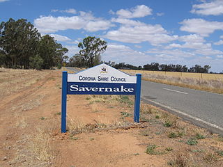
Savernake is a village and rural community in the southern Riverina region of New South Wales, Australia. The village is located on the Riverina Highway, east of Berrigan, and in the Federation Council local government area.

Milbrulong is a locality in the central east part of the Riverina region of New South Wales, Australia.

Hopefield is a rural community in the central south part of the Riverina. It is situated by road, about 12 kilometres south west of Balldale and 12 kilometres north east of Corowa. At the 2006 census, Hopefield had a population of 308 people.

The Rennie Football Netball Club is an Australian rules football and netball club based in the southern Riverina town of Rennie.
The Rutherglen Football Club was an Australian rules football club based in Rutherglen, Victoria, being a founding member of the Ovens & Murray Football League in 1893. In 1979, the club merged with Corowa to form the Corowa-Rutherglen FC, joining the Ovens & Murray Football League.
The Chiltern & District Football Association was first established in 1912 from the following Australian Rules Football clubs - Barnawartha, Chiltern, Chiltern Valley, Christmastown, Southern and Wodonga, in North Eastern Victoria, Australia and was an active competition until 1956 when it was wound up.
Wahgunyah Football / Netball Club is an Australian Rules Football club based in North Eastern Victoria that currently competes in the Tallangatta & District Football League.
The Central Hume Football Association was an Australian Rules Football competition that was first established in 1928 after a meeting comprising the following clubs: Bowna, Burrumbuttock, Gerogery, Jindera and Walbundrie and was based at Jindera in the Riverina area, New South Wales.
The Riverina Football Association was an Australian rules football competition formed in 1924 from the following clubs - Balldale, Brocklesby Culcairn, Henty Town, Henty Rovers, Holbrook and Walla Walla.