
Rear-Admiral Sir William Edward Parry was an Anglo-Welsh explorer of the Arctic best known for his 1819–1820 expedition through the Parry Channel, probably the most successful in the long quest for the Northwest Passage, until it was finally negotiated by Roald Amundsen in 1906.

Kiama is a coastal town 120 kilometres south of Sydney in the Illawarra. One of the main tourist attractions is the Kiama Blowhole. Kiama features several popular surfing beaches and caravan parks, and numerous alfresco cafes and restaurants. Its proximity to the south of Sydney makes it an attractive destination for many day-trippers and weekenders.
Koraleigh is a small village in the west of the Riverina region of New South Wales, Australia. The village is on the Murray River and in Murray River Council local government area. Koraleigh is 6 kilometres (3.7 mi) northeast of Nyah, Victoria and 15 kilometres (9.3 mi) south of Tooleybuc.

Oaklands is a town in the Riverina district of southern New South Wales, Australia. The town is located 615 kilometres south west of the state capital, Sydney and 105 kilometres north west of Albury. Oaklands is in the Federation Council local government area and at the 2011 census, had a population of 238.

Kyalite is a locality on the Wakool River in the Riverina district of the Australian state of New South Wales. It is part of Balranald Shire and is approximately 890 kilometres (550 mi) south west of the state capital Sydney and 400 kilometres (250 mi) north west of Melbourne. Kyalite was formerly known as Wakool Crossing. At the 2006 census, Kyalite had a population of 108.

Bungowannah is a locality in the Riverina region of New South Wales, Australia. The locality is on the Riverina Highway, about 16 kilometres (9.9 mi) north west of Albury and 8 kilometres (5.0 mi) south east of Howlong.

Caldwell is an Australian village community in the Deniboota Irrigation Area in the central south part of the Riverina and situated about 45 kilometres (28 mi) west from Deniliquin, New South Wales and 10 kilometres (6.2 mi) north west from Tantonan.
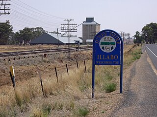
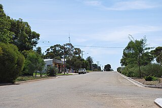
Illabo is a locality in the South West Slopes part of the Riverina in New South Wales, Australia. It is situated about 13 kilometres (8 mi) southwest of Bethungra and 16 kilometres (10 mi) northeast of Junee. At the 2016 census, Illabo had a population of 144.
Yallakool is an unbounded village community within the locality of Caldwell in the central south part of the Riverina in New South Wales, Australia. It is situated by road about 10 kilometres (6.2 mi) north west of Caldwell and 50 kilometres (31 mi) west of Deniliquin, but is a part of the Murray River Council.

Woomargama is a locality in southeastern New South Wales, Australia. The locality is in the South West Slopes region, in the foothills of the Great Dividing Range. It is in the Greater Hume Shire local government area, 508 kilometres (316 mi) south west of the state capital, Sydney and 48 kilometres (30 mi) north east of the regional city of Albury. At the 2006 census, Woomargama had a population of 251.

Wymah is a rural community in the south-east part of the Riverina very close to the border of Victoria, Australia. It is situated by road, about 11 kilometres (7 mi) south of Bowna and 23 kilometres (14 mi) west of Talmalmo. Wymah is situated on the Wymah River Road accessible from Bowna. At the 2016 census, Wymah had a population of 37.
Tantonan is a rural locality in the central south part of the Riverina, New South Wales, Australia. It is situated by road, about 8 kilometres north west from Caldwell and 13 kilometres south east from Bunnaloo.
Peranga is a rural town and locality in the Toowoomba Region, Queensland, Australia. In the 2016 census the locality of Peranga had a population of 85 people.

The Southern Cross Rally was a major international rally mainly held in the Port Macquarie region of New South Wales, Australia, between 1966 and 1980. The rally attracted many of the world's leading rally drivers and factory teams.
Berrook is a locality situated in remote north-west Victoria in the Sunraysia region. The place by road, about 8 kilometres east from Peebinga South Australia and only about 3 kilometres from the South Australian Border. It can be found by following the Panitya- Berrook unsealed road north for 30 kilometres from Sunset. It is in the local government area of the Rural City of Mildura.

Mad Max is an Australian post-apocalyptic action film series and media franchise created by George Miller and Byron Kennedy. It began in 1979 with Mad Max, and was followed by three sequels: Mad Max 2, Mad Max Beyond Thunderdome (1985) and Mad Max: Fury Road (2015); Miller directed or co-directed all four films. Mel Gibson starred in the first three films and Tom Hardy took over as Max in the fourth film.
Tomerong is a village in the South Coast region of New South Wales, Australia. It is located approximately 180 kilometres by road south from the state capital Sydney and 20 kilometres south of the commercial centre of the City of Shoalhaven, Nowra in the County of St Vincent. The village is eight kilometres inland of the western shores of Jervis Bay. Its population at the 2016 census was 1,065.

Mad Max: Fury Road is a 2015 Australian post-apocalyptic action film co-written, co-produced, and directed by George Miller. Miller collaborated with Brendan McCarthy and Nico Lathouris on the screenplay. The fourth instalment and a "revisiting" of the Mad Max franchise, it was produced by Village Roadshow Pictures, Kennedy Miller Mitchell and RatPac-Dune Entertainment and distributed by Roadshow Entertainment in Australia and by Warner Bros. Pictures internationally. The film stars Tom Hardy, Charlize Theron, Nicholas Hoult, Hugh Keays-Byrne, Rosie Huntington-Whiteley, Riley Keough, Zoë Kravitz, Abbey Lee, and Courtney Eaton. Set in a post-apocalyptic desert wasteland where gasoline and water are scarce commodities, Fury Road follows Max Rockatansky, who joins forces with Imperator Furiosa to flee from cult leader Immortan Joe and his army in an armoured tanker truck, leading to a lengthy road battle.
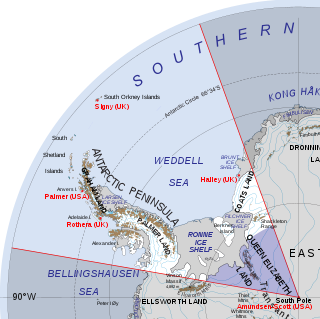
Queen Elizabeth Land is portion of mainland Antarctica named by the government of the United Kingdom and claimed as part of the British Antarctic Territory, which is the largest of the 14 British Overseas Territories. Situated south of Weddell Sea and between longitudes 20°W and 80°W, stretching from Filchner-Ronne Ice Shelf to the South Pole. The boundary against Zumberge Coast of Ellsworth Land to the West and Northwest is Hercules Inlet. To the northeast, circle of latitude 82°S is the dividing line against Coats Land. The area of Queen Elizabeth Land was unnamed until 2012, though most of it was unofficially known as Edith Ronne Land in 1947–68 and includes areas claimed by the United Kingdom, Chile and Argentina.
The Georges Creek, a perennial stream that is part of the Macleay River catchment, is located in the Northern Tablelands and Mid North Coast regions of New South Wales, Australia.

