Narrabri is a town and seat of Narrabri Shire local government area in the North West Slopes, New South Wales, Australia on the Namoi River, 521 kilometres (324 mi) northwest of Sydney. It sits on the junction of the Kamilaroi Highway and the Newell Highway. At the 2016 census, the town of Narrabri had a population of 5,903.

Quirindi is a small town on the North West Slopes region of New South Wales, Australia, in Liverpool Plains Shire. At the 2011 census, Quirindi had a population of 2,580. It is the nearest link to Gunnedah to the west and Tamworth to the north. The local economy is based on agriculture, with broadacre farming dominant on the black soil plains to the west and livestock grazing in the hilly eastern part of the district.

Henty is a town in southwestern New South Wales close to the boundaries of the South West Slopes and the Riverina districts, almost midway between the regional cities of Albury and Wagga Wagga. At the 2006 census, Henty had a population of 863 people.

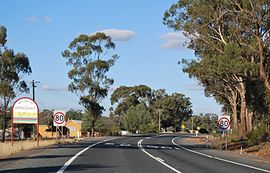
Bethungra is a locality in Junee Shire in the South West Slopes region of New South Wales, Australia situated on the Olympic Highway about 13 kilometres northeast of Illabo and 24 kilometres southwest of Cootamundra.

Carrathool is a village in the western Riverina region of New South Wales, Australia, in Carrathool Shire. In 2011 census, Carrathool had a population of 296 people. It is about 5 kilometres (3 mi) north of the Sturt Highway between Darlington Point and Hay. The village is situated on the plain a few kilometres north of the river, clustered around the now-disused railway station.

Ganmain is a town in the Riverina region of New South Wales, Australia. Ganmain is located around 55 kilometres (34 mi) north west of Wagga Wagga, and 50 kilometres (31 mi) east of Narrandera. Ganmain is in the Coolamon Shire local government area and had a population at the 2016 census of 779.

Downside is a farming community in the central east part of the Riverina and situated about 15 kilometres north west from Wagga Wagga and 24 kilometres south east from Coolamon.
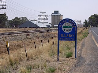
Illabo is a locality in the South West Slopes part of the Riverina in New South Wales, Australia. It is situated about 13 kilometres (8 mi) southwest of Bethungra and 16 kilometres (10 mi) northeast of Junee. At the 2016 census, Illabo had a population of 144.
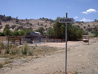
Kyeamba is a farming community in the central east part of the Riverina and situated about 16 kilometres (9.9 mi) north west of Humula and 23 kilometres (14 mi) south west of Tarcutta. At the 2016 census, Kyeamba had a population of 54.

Rosewood is a village community and locality in the south east part of the Riverina, New South Wales, Australia. It is situated about 16 kilometres (9.9 mi) south east from Carabost and 19 kilometres (12 mi) north west from Tumbarumba. At the 2016 census, Rosewood had a population of 214. The village is administered by two local governments; the northern part of the locality by the Greater Hume Shire and the southern part of the locality by the Snowy Valleys Council. The village of Rosewood is within the Snowy Valleys Council area.

Woolgarlo is a locality on the foreshores of the Yass River arm of Lake Burrinjuck, in the far eastern part of the Riverina in the Yass Valley Shire of New South Wales, Australia. At the 2016 census, it had a population of 26.

Kamarah, is a village community in the central north part of the Riverina. It is situated by road, about 11 kilometres west of Ardlethan and 12 kilometres east of Moombooldool. At the 2006 census, Kamarah had a population of 130 people.
Bowna is a locality in the South East part of the Riverina, New South Wales, Australia.

Table Top is an outer suburb of the city of Albury, New South Wales, located 16 kilometres (10 mi) north of Albury and 19 kilometres (12 mi) west of Bowna. At the 2011 census, Table Top had a population of 1253. The area used to be part of the Greater Hume Shire but was recently integrated into the City of Albury.

Wymah is a rural community in the south-east part of the Riverina very close to the border of Victoria, Australia. It is situated by road, about 11 kilometres (7 mi) south of Bowna and 23 kilometres (14 mi) west of Talmalmo. Wymah is situated on the Wymah River Road accessible from Bowna. At the 2016 census, Wymah had a population of 37.

Combaning is a rural community in the north east part of the Riverina. It is situated by road, about 3 kilometres west of Springdale and 13 kilometres east of Temora. At the 2006 census, Combaning had a population of 214 people.

Widgiewa is a small community in the central part of the Riverina in New South Wales, Australia.
Bundure is a rural community in the central south part of the Riverina. It is situated by road, about 25 kilometres south west of Widgiewa and 33 kilometres north east of Jerilderie. In 2006, Bundure had a population of 274 people.

Currawarna is a rural community in the central east part of the Riverina. It is situated by road, about 6 kilometres north west of Millwood and 32 kilometres south of Coolamon. At the 2016 census, Currawarna had a population of 189 people.

Wandsworth is a locality on the Northern Tablelands in the New England region of New South Wales, Australia.