Menzies Creek is a township in Melbourne, Victoria, Australia, 40 km east of Melbourne's Central Business District, located within the Shires of Cardinia and Yarra Ranges local government areas. Menzies Creek recorded a population of 998 at the 2016 census.
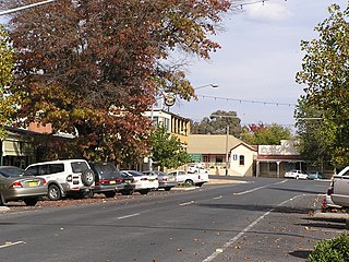
Tumbarumba is a small town in New South Wales, Australia, about 480 kilometres (300 mi) southwest of the state capital, Sydney. Tumbarumba is located on the periphery of the Riverina and South West Slopes regions at the western edge of the Snowy Mountains. The 2016 census showed the population of the town and surrounding area to be 1,862 people. Locals refer to the town as 'Tumba'.
Tarcutta is a town in south-western New South Wales, Australia. The town is 438 kilometres (272 mi) south-west of Sydney, 3 kilometres (1.9 mi) east of the Hume Highway, It was proclaimed as a village on 28 October 1890. As of 2016, the town had a population of 446.

Alexandra is a significant regional centre in north-east Victoria, Australia, 130 kilometres north-east of the State Capital, Melbourne. It is located at the junction of the Goulburn Valley Highway (B340) and Maroondah Highway (B360), in the Shire of Murrindindi local government area. At the 2016 census, the town had a population of 2,695 and the broader area a population of 6420.

Drouin is a town in the West Gippsland region, 90 kilometres (56 mi) east of Melbourne, in the Australian state of Victoria. Its local government area is the Shire of Baw Baw, and is home to the council headquarters despite being the second-largest town in the shire, behind neighbouring Warragul. The town is supposedly named after a Frenchman who invented a chlorination process for the extraction of ore, or an Aboriginal word meaning "north wind". New housing developments have accelerated the town's residential growth in recent years. As at the 2016 census, Drouin had a population of 11,887 people.

Walhalla is a small town in Victoria, Australia, founded as a gold-mining community in late 1862, and at its peak, home to around 4,000 residents. As of 2016, the town has a population of 20 permanent residents, though it has a large proportion of houses owned as holiday properties. It attracts large numbers of tourists and is a major focus of the regional tourism industry. The town's name is taken from an early gold mine in the area, named for the German hall of fame, the Walhalla temple.

Mount Perry is a small town and locality in the North Burnett Region in southeastern Queensland, Australia. In the 2016 census, Mount Perry had a population of 538 people. The neighbourhood of Drummers Creek is in the locality.
Marburg is a rural town in the City of Ipswich and a locality split between the City of Ipswich and the Somerset Region, both in Queensland, Australia. In the 2016 census, Marburg had a population of 873 people.

Batlow is a town in the South West Slopes region of New South Wales, Australia, on the edge of the Great Dividing Range, 775 m above sea level.

Taradale is a small town in Victoria, Australia. It is located beside the Calder Highway between Melbourne and Bendigo. Its local government area is the Shire of Mount Alexander. At the 2016 census, Taradale had a population of 448.
Clematis is a suburb in Melbourne, Victoria, Australia, 42 km south-east from Melbourne's central business district. Its local government area is the Shire of Cardinia. At the 2016 census, Clematis had a population of 350.

Carabost is a foresting community in the south-east part of the Riverina. It is situated about 16 kilometres north west of Rosewood and 22 kilometres south east of Kyeamba.
Toongabbie is a small country town located in southeastern Victoria Australia, 177 kilometres (110 mi) from Melbourne and just north of Traralgon. The railway station was closed in 1986 and the former railway line has now been incorporated into the Gippsland Plains Rail Trail. At the 2016 census, Toongabbie had a population of 500.

The Tumbarumba railway line is a railway line in New South Wales, Australia. Proposals were commenced back as early as 1881. The length of an initial proposal showed it to be 74 miles 64 chains (120.4 km) in length. The final built length being 80 miles (129 km).

Gordon is a small town in Victoria, Australia, named after settler George Gordon. The town is located on the Old Melbourne Road in the Shire of Moorabool local government area, 95 kilometres (59 mi) west of the state capital, Melbourne. At the 2011 census, Gordon had a population of 1,151.

Campbells Creek is a town in Victoria, Australia.

Ravenswood is a rural town and locality in the Charters Towers Region, Queensland, Australia. In the 2016 census, the locality of Ravenswood had a population of 255 people.

Maxwelton is an outback town and locality in the Shire of Richmond in central north Queensland, Australia. In the 2016 census, the locality of Maxwelton had a population of 22 people.

Curra is a rural residential locality in the Gympie Region, Queensland, Australia. In the 2016 census, Curra had a population of 1,920 people.
Pindi Pindi is a rural locality in the Mackay Region, Queensland, Australia. In the 2016 census Pindi Pindi had a population of 98 people.

