
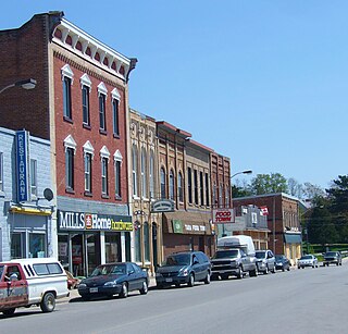
Tocumwal is a town in the southern Riverina region of New South Wales, Australia, in the Berrigan Shire local government area. The town, 270 kilometres (170 mi) north of the city of Melbourne, lies on the northern bank of the Murray River, which forms the border with Victoria.
Tara is an unincorporated community in the municipality of Arran–Elderslie, Bruce County, in southwestern Ontario, Canada. It is a designated place and had 1,037 residents and 458 dwellings as of the 2011 census. Tara is in geographic Arran Township and is located on the Sauble River. It has an area of 2.39 square kilometres (0.92 sq mi) and an urban area that covers 63.5 square kilometres (24.5 sq mi).

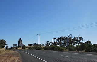
Perenjori is a townsite in the northern agricultural region, 348 kilometres (216 mi) north of Perth and 39 kilometres (24 mi) south-east of Morawa. It is located on the Wongan Hills to Mullewa railway line which was opened in 1915. Perenjori was approved as the name of a siding in April 1913, and later that year the government decided to establish a townsite there. Perenjori townsite was gazetted in 1916.
Antwerp is a locality in Victoria, Australia on the Dimboola – Rainbow Road, in the Shire of Hindmarsh, 14 kilometres (8.7 mi) north of Dimboola and 356 kilometres (221 mi) north-west of Melbourne. The Wimmera River passes 500 metres (550 yd) west of the locality. The population at the 2016 census was 63.
The Catlins River Branch was a branch line railway that formed part of New Zealand's national rail network. It ran through the Catlins region in southwestern Otago and was built in sections between 1879 and 1915. It closed in 1971 except for the first four kilometres, which remain open as the Finegand Branch. Along the line was the Hunts Road tunnel, the southernmost tunnel in New Zealand.

Bellata is a small village in north-central New South Wales, Australia, in Narrabri Shire. At the 2006 census, Bellata had a population of 529. The place name Bellata could be derived from the local Aboriginal word meaning "kangaroo" or possibly "home of belar trees".
The Southbridge Branch was a branch line railway that formed part of New Zealand's national rail network. It was located in the Canterbury region of the South Island and operated from 1875 until 1967. Five kilometres of the line remains open as the Hornby Branch, formerly the Hornby Industrial Line.
Mount Currie is a settlement in the Squamish-Lillooet region of southwestern British Columbia. On BC Highway 99, the locality is by road about 160 kilometres (99 mi) north of Vancouver, 39 kilometres (24 mi) northeast of Whistler, and 92 kilometres (57 mi) southwest of Lillooet.

Mathoura is a small town in the Riverina region of southern New South Wales, Australia, in the Murray River Council local government area. At the 2016 census, Mathoura had a population of 938. At the 2021 census the population was 1,002.

Tarro is a north-western suburb of the Newcastle City Council local government area in the Hunter Region of New South Wales, Australia. It, and parts of nearby Beresfield, was originally known as Upper Hexham, "lower" Hexham being an older settlement located about 5 kilometres (3 mi) to the east on the Hunter River. The name "Tarro" reportedly means "stone" in an Aboriginal language.

Womboota is a locality in the centre south part of the Riverina. It is situated by road, about 26 kilometres (16 mi) north from Moama and 28 kilometres (17 mi) south west from Bunnaloo. At the 2016 census, Womboota had a population of 105.
Brightwater railway station was a rural railway station that served the town of Brightwater in the Tasman district of New Zealand’s South Island. Brightwater is located on State Highway 6, approximately midway between the towns of Richmond, to the north, and Wakefield, to the south. It was one of 25 stations on the Nelson Section, and existed from 1876 to 1955.
Slocan Park is an unincorporated community on the east side of the Slocan River in the West Kootenay region of southern British Columbia. The neighbourhood on Highway 6 is about 9 kilometres (6 mi) north of Crescent Valley and 36 kilometres (22 mi) south of Slocan.
Red Gap is southeast of Nanoose Bay on the east coast of southern Vancouver Island, British Columbia. The ghost town on BC Highway 19 is by road about 22 kilometres (14 mi) north of Nanaimo, and 16 kilometres (10 mi) south of Parksville.
The Cambridge Branch is a rural railway line in the Waikato, New Zealand. The line stretches from Ruakura Junction for 15.08 kilometres (9.37 mi) to the settlement of Hautapu, having previously continued another 4.19 kilometres (2.60 mi) to the township of Cambridge. It had five stations along its length, at Newstead, Matangi (Tamahere), Bruntwood (Fencourt), Hautapu and the terminus at Cambridge.

Deniliquin is a town in the Riverina region of New South Wales, Australia, close to the border with Victoria. It is the largest town in the Edward River Council local government area.

Makino Road railway station was a station on the North Island Main Trunk in New Zealand. It was a request stop, 49 mi (79 km) south of Wanganui and 2 mi (3.2 km) north of Feilding.

Parson is an unincorporated community on the east shore of the Columbia River, in the Columbia Valley region of southeastern British Columbia. The locality, on BC Highway 95, is by road about 212 kilometres (132 mi) north of Cranbrook and 35 kilometres (22 mi) southeast of Golden.

The Cairns-to-Kuranda Railway is a heritage-listed railway line from the Cairns Region to the Shire of Mareeba, both in Queensland, Australia. It commences at Redlynch, a suburb of Cairns and travels up the Great Dividing Range to Kuranda within the Shire of Mareeba on the Atherton Tableland. It was built from 1913 to 1915 by Queensland Railways. Components of it include Stoney Creek Bridge, the Rail Bridge over Christmas Creek, Kuranda railway station, and Surprise Creek Rail Bridge. It was added to the Queensland Heritage Register on 21 August 1992. The railway is used to operate a tourist rail service, the Kuranda Scenic Railway. It forms part of the Tablelands railway line.
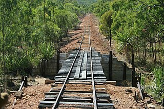
The Etheridge railway line is a heritage-listed railway line between Mount Surprise and Forsayth, both in the Shire of Etheridge, Queensland, Australia. It includes Mount Surprise railway station, Einasleigh railway station, Wirra Wirra railway station and Forsayth railway station. Etheridge railway line was added to the Queensland Heritage Register on 16 February 2009.
