
Junee is a medium-sized town in the Riverina region of New South Wales, Australia. The town's prosperity and mixed services economy is based on a combination of agriculture, rail transport, light industry and government services, and in particular correctional services. In 2015 Junee's urban population was 4,762.
Koraleigh is a small village in the west of the Riverina region of New South Wales, Australia. The village is on the Murray River and in Murray River Council local government area. Koraleigh is 6 kilometres (3.7 mi) northeast of Nyah, Victoria and 15 kilometres (9.3 mi) south of Tooleybuc.
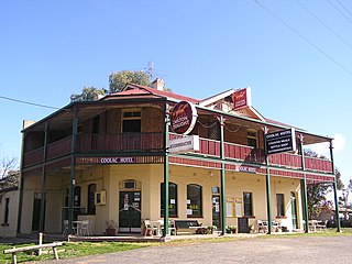
Coolac is a village in the Riverina region of New South Wales, Australia in Gundagai Council. At the 2016 census, Coolac had a population of 216.
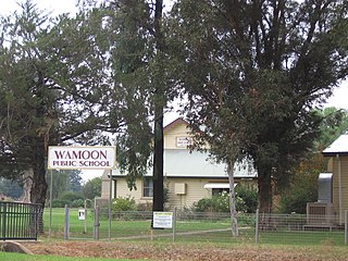
Wamoon is a village in Leeton Shire in the Riverina region of New South Wales, Australia. Wamoon is located 8.8 kilometres (5.5 mi) from Leeton along the Irrigation Way to the Leeton CBD and Henry Lawson Drive to the Leeton suburb of Wattle Hill. Wamoon provides a village of homes to the farmers of northern Leeton and there is a small primary school known as Wamoon Public School.

Grong Grong is a small town that is located in the Riverina region of New South Wales, Australia. The town is situated on the Newell Highway, 23 kilometres (14 mi) east of Narrandera in the Shire of Narrandera.
Coolamon is a town in the Riverina region of south-west New South Wales, Australia. Coolamon is 40 kilometres (25 mi) north-west of Wagga Wagga and 506 kilometres (314 mi) south-west of Sydney via the Hume and Sturt Highways. The town is situated on the railway line between Junee and Narrandera. Coolamon had a population of 2,199 at the 2016 census and is 290 metres (950 ft) above sea level. It is the administrative and service centre for the local government area which bears its name—Coolamon Shire.

Collingullie is a village 26 kilometres (16 mi) north-west of Wagga Wagga in the Riverina region of New South Wales, Australia. The village is located on the Sturt Highway, between Wagga Wagga and Narrandera, at the crossroads with the road to Lockhart.
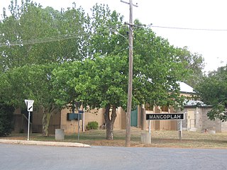
Mangoplah is a town approximately 36 kilometres (22 mi) south of Wagga Wagga in the Riverina region of New South Wales, Australia. At the 2016 census, Mangoplah had a population of 309. The name of the town is believed to mean "Kooris singing" in the Wiradjuri aboriginal language.
The Berrigan Football Club, nicknamed the Saints, is an Australian Rules Football club playing in the Picola & District Football League. The club is based in the small town of Berrigan located in the Riverina district of New South Wales.
The Tocumwal Football / Netball Club, nicknamed the Bloods, is an Australian Rules Football club that entered the Picola & District Football League in 2014.

Ganmain is a town in the Riverina region of New South Wales, Australia. Ganmain is located around 55 kilometres (34 mi) north west of Wagga Wagga, and 50 kilometres (31 mi) east of Narrandera. Ganmain is in the Coolamon Shire local government area and had a population at the 2016 census of 779.
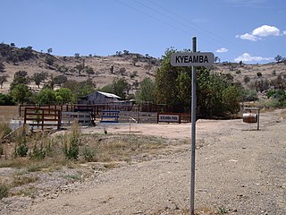
Kyeamba is a farming community in the central east part of the Riverina and situated about 16 kilometres (9.9 mi) north west of Humula and 23 kilometres (14 mi) south west of Tarcutta. At the 2016 census, Kyeamba had a population of 54.

Rosewood is a village community and locality in the south east part of the Riverina, New South Wales, Australia. It is situated about 16 kilometres (9.9 mi) south east from Carabost and 19 kilometres (12 mi) north west from Tumbarumba. At the 2016 census, Rosewood had a population of 214. The village is administered by two local governments; the northern part of the locality by the Greater Hume Shire and the southern part of the locality by the Snowy Valleys Council. The village of Rosewood is within the Snowy Valleys Council area.

Kamarah, is a village community in the central north part of the Riverina. It is situated by road, about 11 kilometres west of Ardlethan and 12 kilometres east of Moombooldool. At the 2006 census, Kamarah had a population of 130 people.

Bowna is a locality in the South East part of the Riverina, New South Wales, Australia.

Mirrool is a town in the northern part of the Riverina region of south-west New South Wales, Australia. The town is in the Bland Shire local government area and adjacent to the Newell Highway, 473 kilometres (294 mi) south west of the state capital, Sydney. At the 2011 census, Mirrool and the surrounding area had a population of 234.

Junee Reefs is a locality in the south east part of the Riverina, Australia. It is situated by road, about 19 kilometres north of Old Junee and 19 kilometres south of Sebastopol. At the 2006 census, Junee Reefs had a population of 136 people.

Milbrulong is a locality in the central east part of the Riverina region of New South Wales, Australia. The locality is 515 kilometres (320 mi) south west of the state capital, Sydney and 59 kilometres (37 mi) south west of the regional centre Wagga Wagga in the Lockhart Shire local government area. The standard gauge Oaklands railway line passes through the locality.
Bundure is a rural community in the central south part of the Riverina. It is situated by road, about 25 kilometres south west of Widgiewa and 33 kilometres north east of Jerilderie. In 2006, Bundure had a population of 274 people.
In the state of New South Wales, Australia, there are many areas which are commonly known by regional names. Regions are areas that share similar characteristics. These characteristics may be natural such as the Murray River, the coastline, or the Snowy Mountains. Alternatively, the characteristics may be cultural, such as a viticulture land use. New South Wales is divided by numerous regional boundaries, based on different characteristics. In many cases boundaries defined by different agencies are coterminous.
