
Yarrawonga is a town in the Shire of Moira local government area in the Australian state of Victoria. In the 2021 census, Yarrawonga had a population of 8,661 people.

Berrigan is a town on the Riverina Highway in the Riverina region of New South Wales, Australia. Berrigan is in the Berrigan Shire local government area and contains the Berrigan Shire Council offices. At the 2016 census, Berrigan had a population of 1,260.

Mulwala is a town in the Federation Council local government area in the Riverina district of New South Wales, Australia. The town is situated on Lake Mulwala, an artificial lake formed by the damming of the Murray River. At the 2021 census, Mulwala had a population of 2,557 people. The town's name is derived from an aboriginal word for 'rain'.

Oaklands is a town in the Riverina district of southern New South Wales, Australia. The town is located 615 kilometres south west of the state capital, Sydney and 105 kilometres north west of Albury. Oaklands is in the Federation Council local government area and at the 2021 census, had a population of 304.
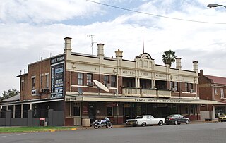
Yenda is a town in the Riverina district of New South Wales, Australia. The town is located about 16 kilometres (9.9 mi) east of Griffith, 65 kilometres (40 mi) north-west of Narrandera, and 550 kilometres (340 mi) west of Sydney in the Murrumbidgee Irrigation Area of southern New South Wales. Although most of the original 15-acre farms have been consolidated into large vineyards and most farmhouses have disappeared, farm roads are named after the original settlers. In 1940 Yenda had two clothing stores, two bakers, two butchers, two grocery stores, two barbers, one newsagency, one pharmacy, one cinema, one Greek restaurant and one bank but residents now do their shopping in nearby Griffith. At the 2011 census, Yenda had a population of 1,503.

Pleasant Hills is a small village about 26 kilometres west of Henty in the Riverina district of New South Wales, Australia. At the 2021 census, Pleasant Hills had a population of 127 people.

Bungowannah is a locality in the Riverina region of New South Wales, Australia. The locality is on the Riverina Highway, about 16 kilometres (9.9 mi) north west of Albury and 8 kilometres (5.0 mi) south east of Howlong.
Marrar is a town in the central east part of the Riverina region of New South Wales. Australia. The town is situated about 21 kilometres (13 mi) west of Old Junee and 32 kilometres (20 mi) north of Downside. At the 2016 census, Marrar had a population of 368.

Rosewood is a village community and locality in the southeast part of the Riverina, New South Wales, Australia. It is situated about 16 kilometres (9.9 mi) southeast from Carabost and 19 kilometres (12 mi) northwest from Tumbarumba. At the 2016 census, Rosewood had a population of 214. The village is administered by two local governments; the northern part of the locality by the Greater Hume Shire and the southern part of the locality by the Snowy Valleys Council. The village of Rosewood is within the Snowy Valleys Council area.
Lacmalac is a rural community in the central east part of the Riverina. It is situated by road, about 9 kilometres east of Tumut and 19 kilometres south east of Gocup.

Urangeline East is a rural community in the central part of the Riverina. It is situated by road, about 9 kilometres southeast from Urangeline and 19 kilometres east from Bidgeemia.

Combaning is a rural community in the north east part of the Riverina. By road it is about 3 kilometres west of Springdale and 13 kilometres east of Temora. At the 2021 census, Combaning had a population of 100 people.

Willbriggie is a community in the central part of the Riverina nearby to the city of Griffith. It is situated by road, about 16 kilometres north from Darlington Point and 17 kilometres south from Hanwood. At the 2021 census, Willbriggie had a population of 127.
Tuppal is a rural locality in the central south part of the Riverina. It is situated by road, about 43 kilometres south east from Deniliquin and 53 kilometres north west from Tocumwal.

Tabbita is a village community in the central part of the Riverina. It is situated by road, on the Kidman Way, about 10 kilometres north west of Warburn and 19 kilometres south east of Goolgowi. The Tabbita area is used prominently for agricultural purposes.
Stony Crossing is a locality in the south western part of the Riverina on the south bank of the Wakool River. By road, it is about 22 kilometres (14 mi) south east from Kyalite and 35 kilometres (22 mi) north west from Swan Hill.
Ryan is a village community in the central south part of the Riverina, in the Australian state of New South Wales. It is situated by road, about 19 kilometres south-west from Henty and 30 kilometres north-east from Walbundrie.
Niemur is a historic village community in the central west part of the Riverina and the site of a railway station. It is situated about 24 kilometres south east of Moulamein and 27 kilometres north west of Burraboi.

Mairjimmy is a rural community in the central south part of the Riverina. It is situated by road, about 17 kilometres south east of Jerilderie and 20 kilometres north west of Berrigan.
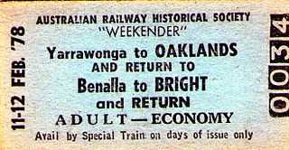
The Oaklands railway line is a freight-only railway line in north-eastern Victoria, Australia. The line branches from the main North East railway at Benalla station and runs across the Victoria-New South Wales border to the town of Oaklands, New South Wales.
