Corowa

Last updated • 7 min readFrom Wikipedia, The Free Encyclopedia

Corowa
New South Wales
Sanger St Corowa.JPG
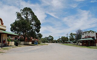
A view of the main street of Corowa
Australia New South Wales location map blank.svg
Red pog.svg
Corowa
Coordinates 35°59′0″S146°23′0″E / 35.98333°S 146.38333°E / -35.98333; 146.38333
Population5,595 (2021 census) [1]
Established1858
Postcode(s) 2646
Elevation143 m (469 ft)
Location
LGA(s) Federation Council
County Hume
State electorate(s) Albury
Federal division(s) Farrer
Mean max tempMean min tempAnnual rainfall
22.5 °C
73 °F
8.8 °C
48 °F
539.4 mm
21.2 in

Corowa /ˈkɒrəwə/ [2] is a town in the state of New South Wales in Australia. It is on the bank of the Murray River, the border between New South Wales and Victoria, opposite the Victorian town of Wahgunyah. It is the largest town in the Federation Council and was the administrative centre of the former Corowa Shire. The name could have derived from an Aboriginal word referring to the curra pine which yielded gum used by Aboriginal people to fasten the heads of spears to the shafts. Another translation is "rocky river". [3]

Contents

There are two bridges over the Murray to Wahgunyah in Victoria: the heritage-listed John Foord Bridge and the Federation Bridge (opened on 2 April 2005). The town in conjunction with nearby town Rutherglen has an Australian Rules football team (Corowa-Rutherglen), competing in the Ovens & Murray Football League, [4] and a rugby league team, the Corowa Cougars, who compete in the Goulburn Murray competition.

History

Bangerang

The Aboriginal people from the area are the Bangarang people.

The tribe of Indigenous Australians that inhabited the Corowa area were called, in their own language, the Bangerang Tribe. The name has various spellings in English, varying all the way from Bandjalang through Panderang to Pinegorine. [5]

Foord's punt

John Foord (c.1820 – 15 February 1883) "The Emperor of Wahgunyah", settled on the Murray River near the Ovens junction (on the southern side of the river) in the early 1840s. In about 1843 Foord and a man named Bould examined the country about the present site of Wahgunyah and recommended it to John Crisp, who was the first European to settle in the area. Later Crisp sold his land to John Foord. With the development of steamer transport on the Murray River in the mid-1850s, Foord purchased a punt which was brought up to Wahgunyah by the steamer Leichhardt. Foord built two extensive warehouses which he let to river navigation companies. Traffic was attracted to Foord's punt, leading to the establishment of Corowa township, opposite to Wahgunyah. [6] In October 1892, the Corowa railway line opened from Culcairn. It closed in January 1989.

Township development

Parkland in Corowa, near the Murray River CorowaParkland.JPG
Parkland in Corowa, near the Murray River

Land was surveyed in 1857 at Corowa by Surveyor Adams and the next year the township was proclaimed. In September 1859 a meeting was held to consider the erection of a bridge between Wahgunyah and Corowa to replace the punt. Construction of a bridge was commenced early in 1861 and the completed structure cost about £8,000. The bridge construction was probably privately funded. [7]

Corowa Post Office opened on 1 January 1861. [8]

In 1861 an Anglican church was built at Corowa on land donated by John Foord. [9]

It was reported in 1868 that Corowa "was fast becoming one of the most important of the border districts". Buildings erected that year included a new store, two hotels and a new court-house. [10]

A branch of the Bank of New South Wales was established in a new brick structure at Corowa in 1874. The building of a Roman Catholic church commenced in September 1874. A report in 1875 stated that Corowa as a township "was making rapid strides". The township had a total of seven hotels. A "private township" had been laid out at Corowa on land formerly owned by Sanger and Foord, with the land selling at £80 to £100 per acre. The Government township, laid out about two miles from the river, was deemed a failure. [7]

A report published in The Sydney Mail in October 1879 stated that Corowa township consisted of one thoroughfare containing the business houses. On a nearby hill the residences of the wealthier residents had been erected. It was claimed that the Government town of Corowa, two miles from the river, was "a vast wilderness". It was postulated that the reason for the failure of this township to develop was the fact that only one approach to the bridge from that point could be obtained. The toll for crossing the bridge was said to be "somewhat exorbitant," and prevented free intercourse between Corowa and Wahgunyah. [11] [12]

Later developments

In 1882 the bridge between Corowa and Wahgunyah was purchased by the New South Wales Government. [7]

A Presbyterian church and an Oddfellows' Hall were built at Corowa in 1886 . [7]

In the 1890s, Corowa was the site of several important conferences leading to the federation of the various colonies into the Commonwealth of Australia in 1901.

Gold mining

A large but spectacularly unsuccessful gold mine, the Corowa Deep Lead Mine, was located just to the north of the town. [13]

There were gold deposits and many gold mines at Rutherglen, on the Victorian side of the border. [14] A working hypothesis was that the gold deposits extended, under the Murray and the inter-colonial border, to Corowa. In 1893, a company was formed to explore the area, by sinking bore holes looking for alluvial gold in a deep lead deposit. [15] [16] By late 1894, gold bearing gravel was struck at a depth of 307 feet. [17]

A new company, Corowa Deep Lead Gold Mining & Prospecting Company No Liability was floated, and work began on the mine in 1897, at a time when the New South Wales Government was attempting to increase gold production in the colony. Its construction was subsidised by the N.S.W. Department of Mines. [18] [19]

Two shafts were sunk. No.2 shaft reached the bottom, by the end of 1898, but only with difficulty due to the pressure of subterranean water encountered. [20] By mid-1899, pumping of water from No.2 Shaft had allowed No.1 Shaft to be sunk more readily, and the subsidy paid by the Mines Department had been increased from £2 to £4 10 per foot of shaft sunk. [21] A proposal to float the venture as an English company in London was defeated on a vote of shareholders. [22] By the end of 1899, No.1 shaft had also reached the bottom at 386 feet. [23] Pumps removed a colossal amount of water from the mine, over 750,000 gallons per day. [24] Cutting drives out from the shaft to the bore sites proved difficult, due to the hard rock encountered. It was necessary to cut through bedrock so that the groundwater in the gold-bearing 'wash' could be drained, via a geologically stable route, and pumped away, prior to extracting the 'wash'. The gold-bearing 'wash' had still not been reached by mid 1901. [25]

Small amounts of gold were produced, by mid 1902, but shareholders were told that there would be more capital needing to be raised to make the mine payable. [26] An optimistic newspaper report, of October 1902, pronounced the mine operations a success, also carrying photographs of the miners, the directors, and the two headframes of the mine. [27] With its capital being exhausted, before reaching the 'wash', the failure of the pumping engine's crankshaft dashed the hopes of long-suffering shareholders. [28] By early 1903, the company had been reconstructed, apparently with an injection of capital from English shareholders, and new machinery was being erected. [29] [30] By September 1904, miners were on 'wash' but it was "rather wet" and not payable. [31] By late 1904, the company again needed additional capital, [32] and a decision was taken that it would be wound up. It had sold 2,033 ounces of gold, from April to November 1904, but costs took much of the revenue; the balance sheet of the company was, by then, only £100 in surplus. The directors were authorised to put the company and all its assets up for sale. [33] [34] The liabilities were discharged, and the company was wound up in 1905. [35]

Neo-Nazi Rally

National Socialist Network demonstrates in Corowa, NSW. Corowa-NSN.png
National Socialist Network demonstrates in Corowa, NSW.

On Saturday the 12th of October 2024, roughly 50 members of the National Socialist Network lead by Thomas Sewell rallied in the town's centre as a response to a local piggery's takeover by multinational meat processor JBS. The group displayed a banner reading "White Man Fight Back" due to JBS's employment of immigrant workers. Police dispersed the group with no arrests being made. [36] [37]

Heritage listings

Corowa has a number of heritage-listed sites, including:

Historical population
YearPop.±%
19212,387    
19332,757+15.5%
19472,751−0.2%
19543,045+10.7%
19612,593−14.8%
19662,709+4.5%
19712,923+7.9%
19763,031+3.7%
19813,390+11.8%
19864,315+27.3%
19915,064+17.4%
19965,785+14.2%
20015,208−10.0%
20065,628+8.1%
20115,450−3.2%
20165,337−2.1%
20215,444+2.0%
Source: Australian Bureau of Statistics data. [41] [42]

Climate

Corowa has a temperate humid subtropical climate (Cfa) with hot, mostly dry summers and cool wetter winters.

Climate data for Corowa Airport (1907–2022, rainfall to 1890); 143 metres or 469 feet AMSL; 35.99° S, 146.36° E
MonthJanFebMarAprMayJunJulAugSepOctNovDecYear
Record high °C (°F)46.0
(114.8)
46.0
(114.8)
40.5
(104.9)
34.0
(93.2)
28.4
(83.1)
23.0
(73.4)
20.0
(68.0)
26.3
(79.3)
33.5
(92.3)
36.0
(96.8)
42.5
(108.5)
42.5
(108.5)
46.0
(114.8)
Mean daily maximum °C (°F)31.9
(89.4)
31.3
(88.3)
27.9
(82.2)
22.5
(72.5)
17.8
(64.0)
13.9
(57.0)
13.1
(55.6)
15.0
(59.0)
18.5
(65.3)
22.2
(72.0)
26.6
(79.9)
30.1
(86.2)
22.6
(72.7)
Mean daily minimum °C (°F)15.7
(60.3)
15.7
(60.3)
12.7
(54.9)
8.6
(47.5)
5.6
(42.1)
3.6
(38.5)
2.8
(37.0)
3.7
(38.7)
5.7
(42.3)
8.1
(46.6)
11.1
(52.0)
13.6
(56.5)
8.9
(48.0)
Record low °C (°F)5.0
(41.0)
6.0
(42.8)
3.9
(39.0)
0.0
(32.0)
−4.5
(23.9)
−5.0
(23.0)
−4.5
(23.9)
−5.0
(23.0)
−2.0
(28.4)
0.0
(32.0)
0.4
(32.7)
3.7
(38.7)
−5.0
(23.0)
Average precipitation mm (inches)36.4
(1.43)
37.4
(1.47)
38.0
(1.50)
36.3
(1.43)
46.6
(1.83)
56.0
(2.20)
54.9
(2.16)
53.3
(2.10)
48.2
(1.90)
51.8
(2.04)
41.7
(1.64)
40.9
(1.61)
541.2
(21.31)
Average precipitation days4.33.94.65.78.010.311.611.49.08.36.25.388.6
Average afternoon relative humidity (%)32333644566768605546383347
Source: [43]

Prominent people

The Corowa Bowling Club was used to film scenes for the 2002 film Crackerjack . [44]

Related Research Articles

<span class="mw-page-title-main">Rutherglen, Victoria</span> Town in Victoria, Australia

Rutherglen is a town in north-eastern Victoria, Australia, near the Murray River border with New South Wales. The town was named after the Scottish town of Rutherglen which lies just outside Glasgow. At the 2021 census, Rutherglen had a population of 2,579.

<span class="mw-page-title-main">Wahgunyah</span> Town in Victoria, Australia

Wahgunyah is a town in northeastern Victoria, Australia. The town is on the southern bank of the Murray River, opposite Corowa, New South Wales, in the Shire of Indigo. Wahgunyah is 298 kilometres (185 mi) north east of the state capital, Melbourne and 51 kilometres (32 mi) west of Albury/Wodonga. At the 2016 census, Wahgunyah had a population of 1,098.

The Coreen & District Football League was an Australian rules football competition in the Coreen district of the Riverina in New South Wales, initially formed in 1909. The netball competition commenced in 1972 in line with the football fixture. The league was disbanded at the end of the 2007 season after 99 years of competition.

<span class="mw-page-title-main">Ovens & Murray Football Netball League</span> Australian rules football and netball competition

The Ovens and Murray Football Netball League is an Australian rules football and netball competition containing ten clubs based in north-eastern Victoria, the southern Riverina region of New South Wales and the Ovens and Murray area. The name comes from the Ovens River, the river in the part of north-eastern Victoria covered by the league, and the Murray River, which separates Victoria and New South Wales.

<span class="mw-page-title-main">Rutherglen Football Club</span> Australian rules football and netball club

The Rutherglen Football and Netball Club is an Australian rules football and netball club playing its home games in Rutherglen, Victoria, Australia. The current Rutherglen FNC was created after the merger of Ovens & Murray Football League sides Rutherglen and Corowa in 1979. Surplus players from the new Corowa-Rutherglen club reformed Rutherglen and played in the Coreen & District Football League for 13 years.
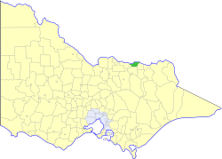
<span class="mw-page-title-main">Shire of Rutherglen</span> Local government area in Victoria, Australia

The Shire of Rutherglen was a local government area about 275 kilometres (171 mi) north-northeast of Melbourne, the state capital of Victoria, Australia. The shire covered an area of 530.9 square kilometres (205.0 sq mi), and existed from 1862 until 1994.

John Frederick Hiskins was an Australian rules footballer who played for Essendon in the Victorian Football League (VFL) during the early 1900s.

<span class="mw-page-title-main">Wahgunyah railway line</span> Former railway line in Victoria, Australia

The Wahgunyah railway is a closed line in north-east Victoria, Australia. Branching off the main North East railway at Springhurst, it ran north-west to Wahgunyah.
<span class="mw-page-title-main">Springhurst, Victoria</span> Town in Victoria, Australia

Springhurst is a town in north-eastern Victoria, Australia. It is in the Rural City of Wangaratta local government area, 280 kilometres (170 mi) north east of the state capital and 16 km from the city of Wangaratta. At the 2016 census, Springhurst and the surrounding area had a population of 348.

<span class="mw-page-title-main">Albury Football Club</span> Australian rules football club

The Albury Football Club, nicknamed the Tigers, is an Australian rules football and netball club based in Albury, a major regional city in New South Wales. Albury football and netball squads compete in the Ovens & Murray Football League.

The Corowa Football Club, nicknamed the Spiders, was an Australian rules football club based in Corowa, New South Wales, that competed in the Ovens & Murray Football League.

<span class="mw-page-title-main">Richard Ball (Australian politician)</span> Politician and engineer in New South Wales, Australia

Richard Thomas Ball was a politician and engineer in New South Wales, Australia.

George Sutherland Smith was a Scotsman who migrated to Australia, working as a builder and paddle-steamer captain. He turned to winemaking with considerable success, founding the All Saints winery in the Rutherglen region of Victoria.

<span class="mw-page-title-main">Corowa Flour Mill</span> Historic site in New South Wales, Australia

The Corowa Flour Mill is a heritage-listed former flour mill and now tourist attraction at Steel Street, Corowa, in the Riverina region of New South Wales, Australia. It is also known as the Corowa Flour Mill and site. It was added to the New South Wales State Heritage Register on 2 April 1999.

<span class="mw-page-title-main">Corowa Courthouse</span> Historic site in New South Wales, Australia

The Corowa Courthouse is a heritage-listed courthouse located at 8 Church Street, Corowa, in the Riverina region of New South Wales, Australia. It was designed by James Barnet, the Colonial Architect, and built from 1886 to 1887 by W. Squires. It is also known as the Corowa Court House. The property is owned by the Department of Justice, an agency of the Government of New South Wales. It was added to the New South Wales State Heritage Register on 22 December 2000.

<span class="mw-page-title-main">Corowa railway station</span> Historic site in New South Wales, Australia

The Corowa railway station is a heritage-listed railway station located on the Culcairn-Corowa line at Corowa, in the Riverina region of New South Wales Australia. It is also known as Corowa Railway Station and yard group. The property was added to the New South Wales State Heritage Register on 2 April 1999.

The Rutherglen Football Club was an Australian rules football club based in Rutherglen, Victoria, being a founding member of the Ovens & Murray Football League in 1893. In 1979, the club merged with Corowa to form the Corowa-Rutherglen FC, joining the Ovens & Murray Football League.

Wahgunyah Football / Netball Club is an Australian Rules Football club based in North Eastern Victoria that currently competes in the Tallangatta & District Football League.

<span class="mw-page-title-main">Mount Boppy Gold Mine</span> Gold mine in New South Wales, Australia

Mount Boppy Gold Mine was a gold mine at Canbelego, New South Wales, Australia. The original Mount Boppy Gold Mine operated from 1901 to 1922. It was, at the time, regarded as being the largest gold producer in New South Wales.

Reno is a rural locality in the Cootamundra–Gundagai Regional Council local government area of the Riverina region, of New South Wales, Australia. There was once a gold mining village of the same name. For many years, until at least 2016, the locality was known as Jones Creek. Its population at the 2021 census was 131.

References

  1. Australian Bureau of Statistics (28 June 2022). "Corowa (State Suburb)". 2021 Census QuickStats. Retrieved 5 November 2012. OOjs UI icon edit-ltr-progressive.svg
  2. Macquarie Dictionary, Fourth Edition (2005). Melbourne, The Macquarie Library Pty Ltd. ISBN   1-876429-14-3
  3. "Corowa". Geographical Names Register (GNR) of NSW. Geographical Names Board of New South Wales . Retrieved 12 July 2009. OOjs UI icon edit-ltr-progressive.svg
  4. Full Points Footy. "Corowa Rutherglen". Archived from the original on 24 July 2008. Retrieved 25 July 2008.{{cite web}}: CS1 maint: unfit URL (link)
  5. Burton, Brian (1973). Flow Gently Past. Corowa: Corowa Shire Council. p. 228. ISBN   0-9599906-1-5.
  6. Jervis, James, 'The Western Riverina: A History of Its Development', Royal Australian Historical Society Journal and Proceedings, Vol. XXXVIII 1952, pp. 142-4.
  7. 1 2 3 4 Jervis, op. cit.
  8. Premier Postal History. "View Post Office Details" . Retrieved 17 March 2018.
  9. "RELIGIOUS MEMORANDA". The Sydney Morning Herald . Vol. XLIV, no. 7291. New South Wales, Australia. 21 October 1861. p. 10 via National Library of Australia.
  10. Jervis, op. cit, citing Pastoral Times (newspaper), 20 June 1868.
  11. Jervis, op. cit, citing The Sydney Mail (newspaper), 28 October 1879.
  12. "Notes on the Riverina District". The Sydney Mail and New South Wales Advertiser . Vol. XXVIII, no. 1007. New South Wales, Australia. 25 October 1879. p. 699 via National Library of Australia.
  13. "Corowa Deep Lead Gold Mine, Corowa, Hume Co., New South Wales, Australia". Mindat.
  14. Hunter, S.B. (1909). "Sketch map of alluvium and deep leads systems. Rutherglen, Chiltern, Barambogie, El Dorado, Everton Et cetera 1:126,720 (2 miles:1 inch) geological map" (PDF). Earth Resources Victoria. Geological Survey of Victoria.
  15. "Corowa Deep Lead Prospecting Co". The Corowa Free Press . 20 October 1893. p. 3.
  16. "Tenders for Boring". Ovens and Murray Advertiser . 4 November 1893. p. 3.
  17. "COROWA DEED LEAD GOLD PROSPECTING COMPANY, LATEST DEVELOPMENTS". The Corowa Free Press . 19 October 1894. p. 7.
  18. "COROWA DEEP LEAD". Sydney Morning Herald . 27 January 1897. p. 9.
  19. "Corowa Deep Lead G. M. Company". Sydney Morning Herald . 1 May 1897. p. 11.
  20. "Mining Notes, Corowa Deep Lead.—No. 2 Shaft". Rutherglen Sun and Chiltern Valley Advertiser . 13 December 1898. p. 2.
  21. "Mining". Evening News (Sydney) . 8 June 1899. p. 8.
  22. "The Deep Lead Mine, English Company Proposal, Special Meeting of Shareholders". The Corowa Free Press . 30 June 1899. p. 3.
  23. "COROWA DEEP LEAD GOLD MINING AND PROSPECTING CO., NO LIABILITY". The Corowa Free Press . 1 December 1899. p. 3.
  24. "WILFUL WASTE IS WOEFUL WANT". The Corowa Free Press . 15 March 1900. p. 2.
  25. "Corowa Deep Lead Company". Daily Telegraph (Sydney) . 6 June 1901. p. 9.
  26. "Corowa Deep Lead". The Albury Banner and Wodonga Express]][[. 6 June 1902. p. 27.
  27. "Deep Lead Mining in New South Wales - Corowa District. SUCCESSFUL OPERATIONS. A Gold-bearing Lead 300 Feet Wide". The Sydney Mail . 22 October 1902. pp. 1062, 1063.
  28. "Corowa Deep Lead Mining Company". The Sydney Mail . 14 January 1903. p. 125.
  29. "Corowa Deep Lead Mine". The Corowa Free Press . 17 February 1903. p. 2.
  30. "Corowa Deep Lead Mine". The Argus (Melbourne) . p. 8.
  31. "Corowa Deep Lead". The Corowa Free Press . 2 September 1904. p. 3.
  32. "Corowa Deep Lead". The Corowa Free Press . 27 September 1904.
  33. "Corowa Deep Lead". The Corowa Free Press . 15 November 1904. p. 2.
  34. "COROWA DEEP LEAD G.M. CO". The Corowa Free Press . 13 December 1904. p. 3.
  35. "COROWA' DEEP LEAD G.M. CO., FiNAL MEETING OF SHAREHOLDERS". The Corowa Free Press . p. 2.
  36. Noticer, The (12 October 2024). "Nationalists protest foreign workers flooding Corowa" . Retrieved 23 December 2024.
  37. "White supremacists rally in country NSW town, angering locals". ABC News. 12 October 2024. Retrieved 23 December 2024.
  38. "Corowa Courthouse". New South Wales State Heritage Register . Department of Planning & Environment. H01450. Retrieved 18 May 2018. CC BY icon.svg Text is licensed by State of New South Wales (Department of Planning and Environment) under CC BY 4.0 licence .
  39. "Corowa Railway Station and yard group". New South Wales State Heritage Register . Department of Planning & Environment. H01120. Retrieved 18 May 2018. CC BY icon.svg Text is licensed by State of New South Wales (Department of Planning and Environment) under CC BY 4.0 licence .
  40. "Corowa Flour Mill and site". New South Wales State Heritage Register . Department of Planning & Environment. H00566. Retrieved 18 May 2018. CC BY icon.svg Text is licensed by State of New South Wales (Department of Planning and Environment) under CC BY 4.0 licence .
  41. "Statistics by Catalogue Number". Australian Bureau of Statistics. Retrieved 7 May 2024.
  42. "Search Census data". Australian Bureau of Statistics. Retrieved 7 May 2024.
  43. "Climate statistics for". Bureau of Meteorology. Retrieved 20 January 2014.
  44. Ball Park lifeline for Corowa Bowls The Border Mail 19 June 2012

Commons-logo.svg Media related to Corowa at Wikimedia Commons