
Valla is a suburb in the Nambucca Valley, on the Mid North Coast of New South Wales, Australia. The name was chosen to match that of the British residence of nineteenth century diplomat Andrew Buchanan.

Grong Grong is a small town that is located in the Riverina region of New South Wales, Australia. The town is situated on the Newell Highway, 23 kilometres (14 mi) east of Narrandera in the Shire of Narrandera.

Bellata is a small village in north-central New South Wales, Australia, in Narrabri Shire. At the 2006 census, Bellata had a population of 529. The place name Bellata could be derived from the local Aboriginal word meaning "kangaroo" or possibly "home of belar trees".
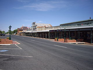
Lockhart is a town in the Riverina Region of New South Wales, Australia. It is the location of the Lockhart Shire Council offices. At the 2016 census, Lockhart had a population of 818 people.

Ben Lomond is a village on the Northern Tablelands in the New England region of New South Wales, Australia. The village is situated 6 km off the New England Highway between Armidale and Glen Innes. It was located in the Guyra Shire local government area until that council was amalgamated into the Armidale Regional Council on 12 May 2016, with parts of the surrounding district in Glen Innes Severn Shire and Inverell Shire. It is primarily a farming area, with most of the residents involved in sheep, cattle and grain farming.

Bethungra is a locality in Junee Shire in the South West Slopes region of New South Wales, Australia situated on the Olympic Highway about 13 kilometres northeast of Illabo and 24 kilometres southwest of Cootamundra.
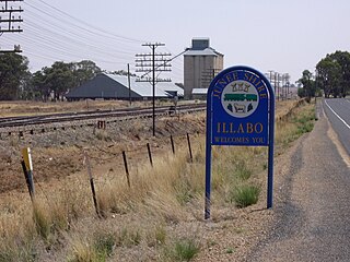
Illabo is a locality in the South West Slopes part of the Riverina in New South Wales, Australia. It is situated about 13 kilometres (8 mi) southwest of Bethungra and 16 kilometres (10 mi) northeast of Junee. At the 2016 census, Illabo had a population of 144.

Adjungbilly is a rural community in the central east part of the Riverina and on the north-western edge of the Snowy Mountains. It is situated about 29 kilometres south-east of Gobarralong and 35 kilometres north-east of Tumut.

Kamarah, is a village community in the central north part of the Riverina. It is situated by road, about 11 kilometres west of Ardlethan and 12 kilometres east of Moombooldool. At the 2006 census, Kamarah had a population of 130 people.

Mirrool is a town in the northern part of the Riverina region of south-west New South Wales, Australia. The town is in the Bland Shire local government area and adjacent to the Newell Highway, 473 kilometres (294 mi) south west of the state capital, Sydney. At the 2011 census, Mirrool and the surrounding area had a population of 234.

Springdale is a village community in the central north part of the Riverina region of the Australian state of New South Wales. It is situated by road, about 3 kilometres east of Combaning and 23 kilometres north west of Stockinbingal. At the 2016 census, it had a population of 150.

Milbrulong is a locality in the central east part of the Riverina region of New South Wales, Australia. The locality is 515 kilometres (320 mi) south west of the state capital, Sydney and 59 kilometres (37 mi) south west of the regional centre Wagga Wagga in the Lockhart Shire local government area. The standard gauge Oaklands railway line passes through the locality.

Bolivia is a locality on the Northern Tablelands in the New England region of New South Wales, Australia. The remains of the settlement comprises the former Bolivia Hotel, a disused post office, a disused railway siding and a community hall.

Llangothlin is a rural locality with several houses, 11 kilometres (7 mi) north of Guyra on the Northern Tablelands in the New England region of New South Wales, Australia. Llangothlin was located in the Guyra Shire local government area until that council was amalgamated into the Armidale Regional Council on 12 May 2016.
Baradine is a small town in north western New South Wales, Australia. At the 2006 census, Baradine had a population of 593.
Antiene is a rural locality of the Muswellbrook Shire local government area in the Hunter Region of New South Wales, Australia. Named after County Antrim in Northern Ireland, the locality was registered as "Antiene" because the request was made in illegible handwriting.

Wollun is a small rural community about 26 kilometres north-west of Walcha and is included in the Uralla Shire local government area of the Northern Tablelands region of New South Wales, Australia.
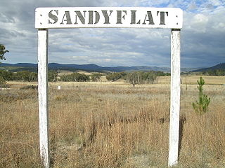
Sandy Flat is a historic locality on the Northern Tablelands in the New England region of New South Wales, Australia. This locality is situated on New England Highway and the former Main North Railway line about 20 kilometres south of Tenterfield. At the 2011 census, Sandy Flat had a population of 209 people.
Kellys Plains is a small rural locality situated about 8 kilometres west south west of Armidale, New South Wales. The settlement is at an altitude of about 1,044 metres on the Northern Tablelands in the New England region of New South Wales, Australia.
Ardglen is a village on the Main North railway line and close to the New England Highway on the North West Slopes region of New South Wales, Australia.
