
The Shire of Macedon Ranges is a region in Central Victoria, Australia, best known for its expansive native forests, iconic geographical attraction Hanging Rock, and thriving artisan food and wine industries. The region covers an area of 1,747 square kilometres (675 sq mi). It is located in between the cities of Bendigo and Melbourne. At the 2016 Census, had a population of 46,100. It includes the towns of Clarkefield, Gisborne South, Gisborne, Kyneton, Lancefield, Macedon, Malmsbury, Mount Macedon, New Gisborne, Riddells Creek, Romsey and Woodend.

The Kaiapoi River is a minor river of north Canterbury, in New Zealand's South Island. Originally called the Cam River, it is a tributary of the Waimakariri River, which it joins at the larger river's estuary. The river is 16 kilometres (10 mi) long, and its drainage area is about 430 square kilometres (170 sq mi).
Woodend is the name of many places:
Sheidow Park is a suburb in the south of Adelaide, South Australia. The suburb is approximately 22 kilometres (14 mi) from the city-centre and is situated on coastal hills above the Adelaide Plains. The size of Sheidow Park is approximately 3.5 square kilometres. It has 9 parks covering nearly 6.1% of total area. The predominant age group in Sheidow Park is 0–9 years.Households in Sheidow Park are primarily couples with children. In general, people in Sheidow Park work in a professional occupation.

Waimakariri District is a local government district, located in the Canterbury region of New Zealand's South Island. It is named after the Waimakariri River, which forms the district's southern boundary, separating it from Christchurch City and the Selwyn District. It is bounded in the north by the Hurunui District and in the east by the Pacific Ocean.
Woodend
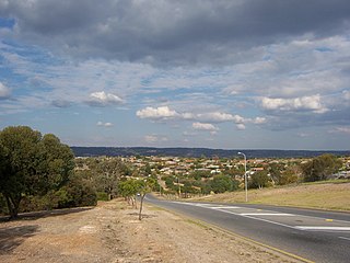
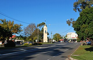
is a small town in Victoria, Australia. The town is in the Shire of Macedon Ranges local government area and is bypassed to the east and north by the Calder Freeway (M79) and is located about halfway between Melbourne and Bendigo. At the 2011 census, Woodend had a population of 5,413.

The Numeralla River, a perennial river that is part of the Murrumbidgee catchment within the Murray–Darling basin, is located in the Monaro region of New South Wales, Australia.

Downside is a farming community in the central east part of the Riverina and situated about 15 kilometres north west from Wagga Wagga and 24 kilometres south east from Coolamon.

Brookdale is a rural locality in the central east part of the Riverina. It is about 8 kilometres, by road, north-west of Bullenbung and 34 kilometres south-east of Galore.

Burrandana is a rural locality in the south eastern part of the Riverina. It is situated by road, about 5 kilometres east south-east of Pulletop and 9 kilometres north of
Mangoplah.

Woodend is an inner-city suburb in the City of Ipswich, Queensland, Australia. The population of Woodend at 2016 was 1302 people.

The Shire of Gisborne was a local government area about 55 kilometres (34 mi) northwest of Melbourne, the state capital of Victoria, Australia. The shire covered an area of 277.13 square kilometres (107.0 sq mi), and existed from 1860 until 1995.

The Shire of Kyneton was a local government area about 85 kilometres (53 mi) northwest of Melbourne, the state capital of Victoria, Australia. The shire covered an area of 725.2 square kilometres (280.0 sq mi), and existed from 1859 until 1995.

The Shire of Newham and Woodend was a local government area about 70 kilometres (43 mi) northwest of Melbourne, the state capital of Victoria, Australia. The shire covered an area of 246.05 square kilometres (95.0 sq mi), and existed from 1861 until 1995.

The Shire of Romsey was a local government area about 65 kilometres (40 mi) north-north-west of Melbourne, the state capital of Victoria, Australia. The shire covered an area of 628 square kilometres (242.5 sq mi), and existed from 1862 until 1995.

Woodend is a town in the Waimakariri District, in the Canterbury Region of the South Island of New Zealand. It may have been named because it was on the edge of what was then called the Maori Bush, or after an early settler, Thomas Wooding. It is situated with both the Waimakariri and Ashley Rivers running either side.

Boorowa River, a perennial stream that is part of the Lachlan catchment within the Murray–Darling basin, is located in the central–western region of New South Wales, Australia.
The Christchurch Northern Motorway is a motorway north of Christchurch, New Zealand, linking the northern Christchurch suburb of Belfast with Pineacres, between Woodend and Kaiapoi, bypassing the Kaiapoi area. The motorway is 10.2 kilometres (6.3 mi) in length, and is four-lane divided except for the two-lane undivided section between the Lineside Road/Smith Street interchange and the northern terminus. The motorway forms part of State Highway 1.
MainPower New Zealand Limited is an electricity distribution company, based in Rangiora, New Zealand, responsible for electricity distribution to over 37,000 customers in the Canterbury Region north of the Waimakariri River. MainPower was formed in 1994, after the Energy Companies Act 1992 required the North Canterbury Electric Power Board to reform into a commercial power company. More reforms in 1998 required electricity companies nationally to split their lines and retail businesses, with MainPower retaining its lines business and selling its retail business to Contact Energy.


