Goulburn County

Last updated

Map all coordinates using: OpenStreetMap  
Download coordinates as: KML  ·  GPX
Goulburn
New South Wales
Goulburn NSW.PNG
Location in New South Wales
Lands administrative divisions around Goulburn:
Mitchell Wynyard Wynyard
Hume Goulburn Selwyn
Bogong (Vic) Benambra (Vic) Selwyn
1886 map of Goulburn county Goulburn county 1886.jpg
1886 map of Goulburn county

Goulburn County is one of the 141 Cadastral divisions of New South Wales. It contains the city of Albury, and the towns of Jindera, Bowna and Woomargama.

Goulburn County was named in honour of the statesman, Henry Goulburn (1784-1856). [1]

Parishes within this county

A full list of parishes found within this county; their current LGA and mapping coordinates to the approximate centre of each location is as follows:

ParishLGACoordinates
Albury City of Albury 36°02′54″S146°54′04″E / 36.04833°S 146.90111°E / -36.04833; 146.90111 (Albury)
Back Creek Greater Hume Shire Council 35°37′54″S147°21′04″E / 35.63167°S 147.35111°E / -35.63167; 147.35111 (Back Creek)
Billabung Greater Hume Shire Council 35°37′54″S147°30′04″E / 35.63167°S 147.50111°E / -35.63167; 147.50111 (Billabung)
Bowna Greater Hume Shire Council 35°59′54″S146°03′04″E / 35.99833°S 146.05111°E / -35.99833; 146.05111 (Bowna)
Carabobala Greater Hume Shire Council 35°40′54″S147°15′04″E / 35.68167°S 147.25111°E / -35.68167; 147.25111 (Carabobala)
Carabost Greater Hume Shire Council 35°35′54″S147°33′04″E / 35.59833°S 147.55111°E / -35.59833; 147.55111 (Carabost)
Coocook Greater Hume Shire Council 35°43′54″S147°33′04″E / 35.73167°S 147.55111°E / -35.73167; 147.55111 (Coocook)
Cookardinia Greater Hume Shire Council 35°35′54″S147°15′04″E / 35.59833°S 147.25111°E / -35.59833; 147.25111 (Cookardinia)
Coppabella Greater Hume Shire Council 35°44′54″S147°42′04″E / 35.74833°S 147.70111°E / -35.74833; 147.70111 (Coppabella)
Cumboroona Greater Hume Shire Council 35°58′54″S147°12′04″E / 35.98167°S 147.20111°E / -35.98167; 147.20111 (Cumboroona)
Currajong Greater Hume Shire Council 35°50′54″S147°38′04″E / 35.84833°S 147.63444°E / -35.84833; 147.63444 (Currajong)
Dora Dora Greater Hume Shire Council 35°51′54″S147°23′04″E / 35.86500°S 147.38444°E / -35.86500; 147.38444 (Dora Dora)
Forest Creek Greater Hume Shire Council 35°34′54″S147°30′04″E / 35.58167°S 147.50111°E / -35.58167; 147.50111 (Forest Creek)
Gerogery Greater Hume Shire Council 35°52′24″S147°01′04″E / 35.87333°S 147.01778°E / -35.87333; 147.01778 (Gerogery)
Holbrook Greater Hume Shire Council 35°42′54″S147°20′04″E / 35.71500°S 147.33444°E / -35.71500; 147.33444 (Holbrook)
Hume Greater Hume Shire Council 35°52′54″S147°15′04″E / 35.88167°S 147.25111°E / -35.88167; 147.25111 (Hume)
Huon Greater Hume Shire Council 35°52′54″S146°55′04″E / 35.88167°S 146.91778°E / -35.88167; 146.91778 (Huon)
Jergyle Greater Hume Shire Council 35°48′54″S147°23′04″E / 35.81500°S 147.38444°E / -35.81500; 147.38444 (Jergyle)
Jerra Jerra Greater Hume Shire Council 35°28′54″S147°13′04″E / 35.48167°S 147.21778°E / -35.48167; 147.21778 (Jerra Jerra)
Jindera Greater Hume Shire Council 35°57′54″S146°55′04″E / 35.96500°S 146.91778°E / -35.96500; 146.91778 (Jindera)
Jingellic Greater Hume Shire Council 35°54′54″S147°39′04″E / 35.91500°S 147.65111°E / -35.91500; 147.65111 (Jingellic)
Little Billabung Greater Hume Shire Council 35°29′54″S147°31′04″E / 35.49833°S 147.51778°E / -35.49833; 147.51778 (Little Billabung)
Mitchell Greater Hume Shire Council 35°47′54″S147°18′04″E / 35.79833°S 147.30111°E / -35.79833; 147.30111 (Mitchell)
Mountain Creek Greater Hume Shire Council 35°46′54″S147°15′04″E / 35.78167°S 147.25111°E / -35.78167; 147.25111 (Mountain Creek)
Mullengandra Greater Hume Shire Council 35°53′54″S147°11′04″E / 35.89833°S 147.18444°E / -35.89833; 147.18444 (Mullengandra)
Mungabarina Greater Hume Shire Council 35°01′54″S146°57′04″E / 35.03167°S 146.95111°E / -35.03167; 146.95111 (Mungabarina)
Murray Greater Hume Shire Council 35°37′24″S147°32′04″E / 35.62333°S 147.53444°E / -35.62333; 147.53444 (Murray)
Narra Narra Wa Greater Hume Shire Council 35°47′54″S147°32′04″E / 35.79833°S 147.53444°E / -35.79833; 147.53444 (Narra Narra Wa)
Pulletop Greater Hume Shire Council 35°33′54″S147°21′04″E / 35.56500°S 147.35111°E / -35.56500; 147.35111 (Pulletop)
Talmalmo Greater Hume Shire Council 35°51′54″S147°33′04″E / 35.86500°S 147.55111°E / -35.86500; 147.55111 (Talmalmo)
Thurgoona City of Albury 36°03′54″S147°00′04″E / 36.06500°S 147.00111°E / -36.06500; 147.00111 (Thurgoona)
Vautier Greater Hume Shire Council 35°51′54″S147°30′04″E / 35.86500°S 147.50111°E / -35.86500; 147.50111 (Vautier)
Wagra Greater Hume Shire Council 35°58′54″S147°15′04″E / 35.98167°S 147.25111°E / -35.98167; 147.25111 (Wagra)
Woomargama Greater Hume Shire Council 35°48′54″S147°10′04″E / 35.81500°S 147.16778°E / -35.81500; 147.16778 (Woomargama)
Wyndham Greater Hume Shire Council 35°56′54″S147°07′04″E / 35.94833°S 147.11778°E / -35.94833; 147.11778 (Wyndham)
Yambla Greater Hume Shire Council 35°55′54″S147°01′04″E / 35.93167°S 147.01778°E / -35.93167; 147.01778 (Yambla)
Yarara Greater Hume Shire Council 35°41′54″S147°39′04″E / 35.69833°S 147.65111°E / -35.69833; 147.65111 (Yarara)
Yarra Yarra Greater Hume Shire Council 35°42′54″S147°27′04″E / 35.71500°S 147.45111°E / -35.71500; 147.45111 (Yarra Yarra)

Related Research Articles

Goulburn, New South Wales City in New South Wales, Australia

Goulburn is a regional city in the Southern Tablelands of the Australian state of New South Wales, approximately 195 kilometres (121 mi) south-west of Sydney, and 90 kilometres (56 mi) north-east of Canberra. It was proclaimed as Australia's first inland city through letters patent by Queen Victoria in 1863. Goulburn had a population of 23,835 at June 2018. Goulburn is the seat of Goulburn Mulwaree Council.

Goulburn River (New South Wales)

Goulburn River, a perennial river of the Hunter River catchment, is located in the Upper Hunter region of New South Wales, Australia.

Wollondilly River

The Wollondilly River, an Australian perennial river that is part of the Hawkesbury–Nepean catchment, is located in the Southern Tablelands and Southern Highlands regions of New South Wales. The river meanders from its western slopes near Crookwell, flowing south-east through Goulburn, turning north-east to near Bullio, flowing north-west to Barrallier, before finally heading north-easterly into its mouth at Lake Burragorang.

Georgiana County Cadastral in New South Wales, Australia

Georgiana County was one of the original Nineteen Counties in New South Wales and is now one of the 141 Cadastral divisions of New South Wales. It lies in the area about halfway between Bathurst and Goulburn. The Lachlan River is the western boundary, with the Crookwell River the southern boundary. It includes Bigga, and the area surrounding the Abercrombie River. It was part of the Electoral district of King and Georgiana from 1856 to 1859.

Argyle County Cadastral in New South Wales, Australia

Argyle County was one of the original Nineteen Counties in New South Wales and is now one of the 141 Cadastral divisions of New South Wales. It includes the area around Goulburn. It is bounded by Lake George in the south-west, the Shoalhaven River in the east, and the Wollondilly River in the north-east.

Brisbane County Cadastral in New South Wales, Australia

Brisbane County was one of the original Nineteen Counties in New South Wales and is now one of the 141 Cadastral divisions of New South Wales. It includes Scone, Merriwa and Murrurundi. The Goulburn River is the boundary to the south and the Hunter River the boundary to the south-east. The Liverpool Range area is the boundary to the north, and the Krui River the boundary to the west.

Bligh County Cadastral in New South Wales, Australia

Bligh County was one of the original Nineteen Counties in New South Wales and is now one of the 141 Cadastral divisions of New South Wales. The Cudgegong River and the Goulburn River are its southern boundaries; the Krui River is the eastern boundary, and the Burragundy River the northern boundary. It includes the villages of Cassilis and Dunedoo.

Phillip County Cadastral in New South Wales, Australia

Phillip County was one of the original Nineteen Counties in New South Wales and is now one of the 141 Cadastral divisions of New South Wales. It includes the area to the east of Mudgee and Gulgong. The Cudgegong River is the border to the south-west, and the Goulburn River the border to the north.

Bungonia, New South Wales Suburb of Goulburn Mulwaree Council, New South Wales, Australia

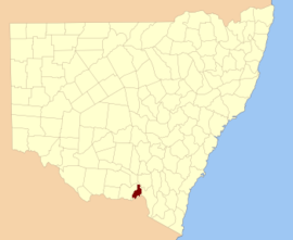
Bungonia is a small town in the Southern Tablelands in New South Wales, Australia in Goulburn Mulwaree. At the 2016 census, Bungonia had a population of 367. The name of the town derives from an Aboriginal word meaning 'sandy creek'.

Parish of Goulburn Cadastral in New South Wales, Australia

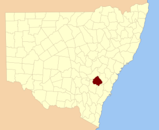
The Parish of Goulburn is a parish of Argyle County which includes most of the city of Goulburn, New South Wales.

Bow River, a partly perennial stream of the Hunter River catchment, is located in the Hunter district of New South Wales, Australia.

Bylong River, a perennial river of the Hunter River catchment, is located in the Central Tablelands and Upper Hunter regions of New South Wales, Australia.

Krui River, a perennial river of the Hunter River catchment, is located in the Upper Hunter region of New South Wales, Australia.

Merriwa River, a perennial river of the Hunter River catchment, is located in the Upper Hunter region of New South Wales, Australia.

The Mulwaree River, a perennial river that is part of the Hawkesbury-Nepean catchment, is located in the Southern Tablelands region of New South Wales, Australia.

Munmurra River, a perennial river of the Hunter River catchment, is located in the Upper Hunter region of New South Wales, Australia.

Worondi Rivulet, a perennial stream of the Hunter River catchment, is located in the Upper Hunter region of New South Wales, Australia.

<i>Goulburn Evening Penny Post</i>

The Goulburn Evening Penny Post was an English-language newspaper published in Goulburn, New South Wales, Australia from 1870 until 1957. At various times the paper was known as Goulburn Evening Penny Post, and Southern Counties General Advertiser, Goulburn and Queanbeyan Evening Penny Post and Southern Counties General Advertiser, Goulburn and Queanbeyan Evening Penny Post and Goulburn Evening Post, and later absorbed a rival newspaper, the Goulburn Herald, before finally shortening its name to the Goulburn Post.

Tirrannaville Town in New South Wales, Australia

Tirrannaville is a locality in the Goulburn Mulwaree Council, New South Wales, Australia. It is located about 11 km south of Goulburn on the road to Braidwood. It was formerly called Terranna, which is the name of the parish covering most of the locality. The northern part of the defined locality, including the small settlement of Tirrannaville and cemetery, is in the parish of Goulburn. At the 2016 census, it had a population of 237. The locality mostly consists of grazing land.

Oallen Town in New South Wales, Australia

Oallen is a locality in the Goulburn Mulwaree Council area, New South Wales, Australia. It is located on the Shoalhaven River and the Oallen Ford Road about 97 km southeast of Goulburn and 106 km southwest of Nowra. The Oallen Ford Road has recently been upgraded to improve the connection from Canberra and Goulburn to Nerriga, Nowra and Jervis Bay. At the 2016 census, Oallen had a population of 141.

References

  1. "Goulburn County". Geographical Names Register (GNR) of NSW. Geographical Names Board of New South Wales. OOjs UI icon edit-ltr-progressive.svg