Selwyn County, New South Wales

Last updated

Map all coordinates using: OpenStreetMap  
Download coordinates as: KML  ·  GPX
Selwyn
New South Wales
Selwyn NSW.PNG
Location in New South Wales
Lands administrative divisions around Selwyn:
Goulburn Wynyard Buccleuch
Goulburn Selwyn Wallace
Benambra (Vic) Tambo (Vic) Wallace

Selwyn County is one of the 141 Cadastral divisions of New South Wales. It is located to the east of the Murray River, with part of the Tumut River as its boundary to the north-east. It includes Mount Kosciuszko, the highest mountain in Australia.

Murray River the longest river in Australia

The Murray River is Australia's longest river, at 2,508 kilometres (1,558 mi) in length. The Murray rises in the Australian Alps, draining the western side of Australia's highest mountains, and then meanders across Australia's inland plains, forming the border between the states of New South Wales and Victoria as it flows to the northwest into South Australia. It turns south at Morgan for its final 315 kilometres (196 mi), reaching the ocean at Lake Alexandrina.

Tumut River

The Tumut River, a perennial stream that is part of the Murrumbidgee catchment within the Murray–Darling basin, is located in the Snowy Mountains and South West Slopes districts of New South Wales, Australia.

Mount Kosciuszko highest mountain in mainland Australia

Mount Kosciuszko is mainland Australia's highest mountain, at 2,228 metres (7,310 ft) above sea level. It is located on the Main Range of the Snowy Mountains in Kosciuszko National Park, part of the Australian Alps National Parks and Reserves, in New South Wales, Australia, and is located west of Crackenback and close to Jindabyne.

Selwyn County was named in honour of geologist Alfred Richard Cecil Selwyn (1824–1902). [1]

Alfred Richard Cecil Selwyn geologist

Alfred Richard Cecil Selwyn, CMG, LL.D, FRS, FGS was a British geologist and public servant, director of the Geological Survey of Victoria from 1852 to 1869, director of the Geological Survey of Canada (GSC) from 1869 to 1894 and President of the Royal Society of Canada from 1895 to 1896.

Parishes within this county

Map all coordinates using: OpenStreetMap  
Download coordinates as: KML  ·  GPX

A full list of parishes found within this county. After the local government mergers of 2016, all parishes of Selwyn County are in the Snowy Valleys Council.

Snowy Valleys Council Local government area in New South Wales, Australia

The Snowy Valleys Council is a local government area located in the South West Slopes region of New South Wales, Australia. This area was formed in 2016 from the merger of the Tumut Shire with the neighbouring Tumbarumba Shire.

ParishCoordinates
Beaumont 35°45′54″S148°10′04″E / 35.76500°S 148.16778°E / -35.76500; 148.16778 (Beaumont)
Boganyera 35°54′54″S147°57′04″E / 35.91500°S 147.95111°E / -35.91500; 147.95111 (Boganyera)
Bringenbrong 36°07′54″S148°03′04″E / 36.13167°S 148.05111°E / -36.13167; 148.05111 (Bringenbrong)
Buccleuch 35°44′54″S148°18′04″E / 35.74833°S 148.30111°E / -35.74833; 148.30111 (Buccleuch)
Buddong 35°38′54″S148°16′04″E / 35.64833°S 148.26778°E / -35.64833; 148.26778 (Buddong)
Burra 35°51′54″S148°03′04″E / 35.86500°S 148.05111°E / -35.86500; 148.05111 (Burra)
Clear Hill 36°04′54″S148°26′04″E / 36.08167°S 148.43444°E / -36.08167; 148.43444 (Clear Hill)
Cowra 35°55′54″S148°17′04″E / 35.93167°S 148.28444°E / -35.93167; 148.28444 (Cowra)
Craven 35°40′54″S147°50′04″E / 35.68167°S 147.83444°E / -35.68167; 147.83444 (Craven)
Dargals 36°09′54″S148°18′04″E / 36.16500°S 148.30111°E / -36.16500; 148.30111 (Dargals)
Geehi 36°19′54″S148°06′04″E / 36.33167°S 148.10111°E / -36.33167; 148.10111 (Geehi)
Glenken 35°55′54″S147°48′04″E / 35.93167°S 147.80111°E / -35.93167; 147.80111 (Glenken)
Glenroy 35°44′54″S147°51′04″E / 35.74833°S 147.85111°E / -35.74833; 147.85111 (Glenroy)
Greg Greg 36°03′54″S148°03′04″E / 36.06500°S 148.05111°E / -36.06500; 148.05111 (Greg Greg)
Gungartan 36°13′54″S148°22′04″E / 36.23167°S 148.36778°E / -36.23167; 148.36778 (Gungartan)
Hay 35°51′54″S148°09′04″E / 35.86500°S 148.15111°E / -35.86500; 148.15111 (Hay)
Hume 36°19′54″S148°11′04″E / 36.33167°S 148.18444°E / -36.33167; 148.18444 (Hume)
Indi 36°13′54″S148°04′04″E / 36.23167°S 148.06778°E / -36.23167; 148.06778 (Indi)
Jagumba 35°58′54″S148°17′04″E / 35.98167°S 148.28444°E / -35.98167; 148.28444 (Jagumba)
Jagungal 36°10′54″S148°23′04″E / 36.18167°S 148.38444°E / -36.18167; 148.38444 (Jagungal)
Jingellic East 35°52′54″S147°45′04″E / 35.88167°S 147.75111°E / -35.88167; 147.75111 (Jingellic East)
Khancoban 36°10′54″S148°11′04″E / 36.18167°S 148.18444°E / -36.18167; 148.18444 (Khancoban)
King 35°44′54″S148°05′04″E / 35.74833°S 148.08444°E / -35.74833; 148.08444 (King)
Kosciusko 36°30′54″S148°12′04″E / 36.51500°S 148.20111°E / -36.51500; 148.20111 (Kosciusko)
Lea 36°07′54″S148°10′04″E / 36.13167°S 148.16778°E / -36.13167; 148.16778 (Lea)
Manjar 35°51′54″S148°19′04″E / 35.86500°S 148.31778°E / -35.86500; 148.31778 (Manjar)
Mannus 35°49′54″S147°57′04″E / 35.83167°S 147.95111°E / -35.83167; 147.95111 (Mannus)
Maragle 35°53′54″S148°09′04″E / 35.89833°S 148.15111°E / -35.89833; 148.15111 (Maragle)
Mate 35°39′54″S147°53′04″E / 35.66500°S 147.88444°E / -35.66500; 147.88444 (Mate)
Munderoo 35°49′54″S147°51′04″E / 35.83167°S 147.85111°E / -35.83167; 147.85111 (Munderoo)
Munyang 36°12′54″S148°27′04″E / 36.21500°S 148.45111°E / -36.21500; 148.45111 (Munyang)
Murray 36°12′54″S148°16′04″E / 36.21500°S 148.26778°E / -36.21500; 148.26778 (Murray)
Nurenmerenmong 35°49′54″S148°15′04″E / 35.83167°S 148.25111°E / -35.83167; 148.25111 (Nurenmerenmong)
Ournie 35°56′54″S147°52′04″E / 35.94833°S 147.86778°E / -35.94833; 147.86778 (Ournie)
Round Hill 35°58′54″S148°23′04″E / 35.98167°S 148.38444°E / -35.98167; 148.38444 (Round Hill)
Scott 35°59′54″S148°30′04″E / 35.99833°S 148.50111°E / -35.99833; 148.50111 (Scott)
Selwyn 35°49′54″S148°24′04″E / 35.83167°S 148.40111°E / -35.83167; 148.40111 (Selwyn)
Table Top 35°55′54″S148°24′04″E / 35.93167°S 148.40111°E / -35.93167; 148.40111 (Table Top)
Tooma 35°55′54″S148°04′04″E / 35.93167°S 148.06778°E / -35.93167; 148.06778 (Tooma)
Tougaroo 36°33′54″S148°13′04″E / 36.56500°S 148.21778°E / -36.56500; 148.21778 (Tougaroo)
Tumbarumba 35°51′54″S148°02′04″E / 35.86500°S 148.03444°E / -35.86500; 148.03444 (Tumbarumba)
Twynam 36°41′54″S148°13′04″E / 36.69833°S 148.21778°E / -36.69833; 148.21778 (Twynam)
Victoria 36°25′54″S148°08′04″E / 36.43167°S 148.13444°E / -36.43167; 148.13444 (Victoria)
Wallace 35°47′54″S148°19′04″E / 35.79833°S 148.31778°E / -35.79833; 148.31778 (Wallace)
Welaregang 35°58′54″S147°56′04″E / 35.98167°S 147.93444°E / -35.98167; 147.93444 (Welaregang)
Welumba 35°58′54″S148°08′04″E / 35.98167°S 148.13444°E / -35.98167; 148.13444 (Welumba)
Yellowin 35°27′54″S148°14′04″E / 35.46500°S 148.23444°E / -35.46500; 148.23444 (Yellowin)
Youngal 36°13′54″S148°10′04″E / 36.23167°S 148.16778°E / -36.23167; 148.16778 (Youngal)

Related Research Articles

Darbalara, New South Wales Town in New South Wales, Australia

Darbalara is a rural community on the east bank of the junction of the Murrumbidgee River and Tumut River in the Riverina. It is situated by road, about 25 kilometres north east of Gundagai and 25 kilometres south of Coolac.

Durham County, New South Wales Cadastral in New South Wales, Australia

Durham County was one of the original Nineteen Counties in New South Wales and is now one of the 141 Cadastral divisions of New South Wales. It is bordered on the south and west by the Hunter River, and on the north and east by the Williams River. It includes Aberdeen and Muswellbrook. Before 1834, the area known as Durham County included what later became Gloucester and most of Brisbane counties, as far west as the Liverpool Range, and east to the Pacific, including Port Stephens, as shown on an 1832 map.

Hunter County Cadastral in New South Wales, Australia

Hunter County was one of the original Nineteen Counties in New South Wales and is now one of the 141 Cadastral divisions of New South Wales. It lies between the Hunter River in the north, and the Colo River in the south, including much of Wollemi National Park. Macdonald River lies to the east.

Westmoreland County, New South Wales Cadastral in New South Wales, Australia

Westmoreland County was one of the original Nineteen Counties in New South Wales and is now one of the 141 Cadastral divisions of New South Wales. It is to the west of Sydney in the Blue Mountains. Coxs River is the border to the north, and the Wollondilly River to the east. Campbells River is the border in the north-east, where the county extends to near Bathurst, with the Fish River part of the border. It includes the town of Oberon, and the Kanangra-Boyd National Park.

King County, New South Wales Cadastral in New South Wales, Australia

King County was one of the original Nineteen Counties in New South Wales and is now one of the 141 Cadastral divisions of New South Wales. It is in the area to the east of Yass. The northern part of it lies between the Lachlan River and the Boorowa River, including the locations of Frogmore, Taylors Flat, Gunnary, Rugby and Rye Park. The Crookwell River is also part of the northern boundary. The Yass River is the southern boundary.

Roxburgh County Cadastral in New South Wales, Australia

Roxburgh County was one of the original Nineteen Counties in New South Wales and is now one of the 141 Cadastral divisions of New South Wales. It includes the area to the north east of Bathurst, lying to the north and east of the Fish River to the junction of the Turon River. It includes Sofala. The Gudgegong River is the border to the north.

Brisbane County Cadastral in New South Wales, Australia

Brisbane County was one of the original Nineteen Counties in New South Wales and is now one of the 141 Cadastral divisions of New South Wales. It includes Scone, Merriwa and Murrurundi. The Goulburn River is the boundary to the south and the Hunter River the boundary to the south-east. The Liverpool Range area is the boundary to the north, and the Krui River the boundary to the west.

Cowley County, New South Wales Cadastral in New South Wales, Australia

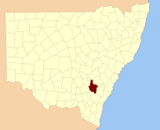
Cowley County is one of the 141 Cadastral divisions of New South Wales. It contains the locality of Cavan. It was originally bordered on the north, east and part of the south by the Murrumbidgee River, and on the west by the Goodradigbee River. A large part of the county was transferred to the Commonwealth to make the Australian Capital Territory in 1909, with the remaining part the area to the north-west of the ACT as far north as the Burrinjuck Dam, and thin strips of land along the western, southern and south-eastern borders of the ACT.

Barrona County Cadastral in New South Wales, Australia

Barrona County is one of the 141 Cadastral divisions of New South Wales. It is bounded by the Warrego River in the east and the Paroo River in the west.

Cowper County Cadastral in New South Wales, Australia

Cowper County, New South Wales is one of the 141 Cadastral divisions of New South Wales.

Ewenmar County Cadastral in New South Wales, Australia

Ewenmar County is one of the 141 Cadastral divisions of New South Wales. It is located between the Macquarie River on the west, and the Castlereagh River on the east. This is the area between Warren and Gilgandra.

Finch County Cadastral in New South Wales, Australia

Finch County is one of the 141 Cadastral divisions of New South Wales. It is bounded by the Narran River in the west, the Barwon River to the south and east, and the Queensland border to the north. It includes Lightning Ridge.

Gowen County Cadastral in New South Wales, Australia

Gowen County is one of the 141 Cadastral divisions of New South Wales. It is located to the east of the Castlereagh River in the area to the east of Gilgandra, to Coonabarabran in the north-east. This includes land on both sides of the Newell Highway.

Irrara County Cadastral in New South Wales, Australia

Irrara County is one of the 141 Cadastral divisions of New South Wales. It is located south of the border with Queensland, east of the Paroo River, and west of the Warrego River.

Narromine County Cadastral in New South Wales, Australia

Narromine County is one of the 141 Cadastral divisions of New South Wales. It is located between the Bogan River on the west and the Macquarie River on the east, in the area around Narromine.

Oxley County Cadastral in New South Wales, Australia

Oxley County, New South Wales is one of the 141 Cadastral divisions of New South Wales. It is located between the Bogan River on the west, and the Macquarie River on the east. This is the area approximately between Warren and Nyngan.

Werunda County Cadastral in New South Wales, Australia

Werunda County is one of the 141 Cadastral divisions of New South Wales. The Darling River is the north-western boundary. It includes Poopelloe Lake, and the area to the east and south-east of Wilcannia.

The Parish of Berrima is a parish of the County of Camden in the Southern Highlands region of New South Wales. Berrima is the largest town in the parish, and the parish includes the land to the north and north-east of this town. The Wingecarribee River forms part of the boundary of the parish in the south, although some of the land near Berrima that is to the south of the river is also included in the parish. Both the old and new Hume Highway pass through the parish from the south-west to the north-east. Gibraltar creek is part of the boundary in the north-east. Bowral and Mittagong are located just to the east of the parish, along with the Southern Highlands railway line. Mandemar is located in the north-west of the parish.

The Parish of Wilton is a parish of the County of Camden in New South Wales, Australia. It is located in the area around where Picton Road crosses the Hume Highway, and the area around nearby Wilton. It is bounded by the Cataract River in the east, the Nepean River in the west and north, and the Cordeaux River in the south-west. Almost the entire boundary of the parish uses rivers, except for a small area in the south-east. The parish extends as far south as Cordeaux Dam.

Bendoc River

The Bendoc River is a perennial river of the Snowy River catchment, located in the Alpine regions of the states of Victoria and New South Wales, Australia.

References

  1. "Selwyn County". Geographical Names Register (GNR) of NSW. Geographical Names Board of New South Wales. OOjs UI icon edit-ltr-progressive.svg