
Albury is a major regional city that is located in the Murray region of New South Wales, Australia. It is part of the twin city of Albury-Wodonga and is located on the Hume Highway and the northern side of the Murray River. Albury is the seat of local government for the council area which also bears the city's name – the City of Albury. It is on the Victoria–New South Wales border.

Glenroy is a suburb in Melbourne, Victoria, Australia, 12 km (7.5 mi) north of Melbourne's Central Business District, located within the City of Merri-bek local government area. Glenroy recorded a population of 23,792 at the 2021 census.

Pascoe Vale South is an inner suburb in Melbourne, Victoria, Australia, 8 km (5.0 mi) north of Melbourne's Central Business District, located within the City of Merri-bek local government area. Pascoe Vale South recorded a population of 10,534 at the 2021 census.

Lavington is the largest suburb of the city of Albury, New South Wales, Australia. At the 2021 census, Lavington had a population of 13,073. Lavington is a mostly flat area near Nail Can Hill to the west, and is bordered by Thurgoona to the east, Hamilton Valley to the west, Springdale Heights to the north, and North Albury to the south. Lavington is mostly residential, but has significant rural areas in the north-west and a commercial area. Features include Lavington Square Shopping Centre, Lavington Swim Centre, Jelbart Park and 5 schools . Lavington is the second major centre of the City of Albury, with its own commercial CBD.
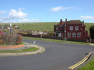
Woodingdean is an eastern suburb of the city of Brighton and Hove, East Sussex, separated from the main part of the city by downland and the Brighton Racecourse. The name Woodingdean came from Woodendean Farm which was situated in the south end of what is now Ovingdean.
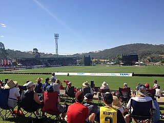
Lavington Sports Ground is a sports ground located in the suburb of Hamilton Valley near Lavington on the north-west fringe of the city of Albury, Australia. The oval is nestled in the side of a hill, with concrete terraces cut into the southern side of the oval below a grass embankment and the grandstand and changing rooms located on the north-west flank. The venue also incorporates a 4 table cricket wicket, a velodrome for track cycling and two netball courts. The Lavington Panthers Sports Club licensed club was formerly located next to the ground, across Hanna Street.

The South Western Slopes, also known as the South West Slopes, is a region predominantly in New South Wales, Australia. It covers the lower inland slopes of the Great Dividing Range, extending from north of Dunedoo through central NSW and into northeast Victoria, meeting its southwestern end around Beechworth. More than 90% of the region is in the state of New South Wales and it occupies about 10% of that state.

The City of Albury is a local government area in the Murray region of New South Wales, Australia. The area covers 305.9 square kilometres (118.1 sq mi) to the north of the Murray River. The area extends around 10 to 12 kilometres east and west along the river from the centre of Albury and up to 20 kilometres (12 mi) north. The population of the City of Albury area was 53,767 in June 2018.
Bowna is a locality in the southeast part of the Riverina, New South Wales, Australia.

Table Top is an outer suburb of the city of Albury, New South Wales, located 16 kilometres (10 mi) north of Albury and 19 kilometres (12 mi) west of Bowna. At the 2021 census, Table Top had a population of 1,516. The area used to be part of the Greater Hume Shire but was recently integrated into the City of Albury.

Thurgoona is an outer suburb of the regional city of Albury in southern New South Wales, Australia. The suburb is located in the City of Albury local government area.
West Albury is a suburb of the city of Albury, New South Wales, located 4 kilometres (2 mi) west of the Albury Central Business District. At the 2016 census, West Albury had a population of 3,851.

East Albury is a suburb of the city of Albury, New South Wales, located 3 kilometres (2 mi) east of the Albury Central Business District. At the 2006 census, East Albury had a population of 5686.
South Albury is a suburb of the city of Albury, New South Wales, located 3 kilometres (2 mi) south of the Albury Central Business District. At the 2006 census, South Albury had a population of 1102.
Hamilton Valley is a suburb of the city of Albury, New South Wales, located north-west of the Albury Central Business District and west of Lavington. At the 2016 census, Hamilton Valley had a population of 566, although the area covered in the Census includes Splitters Creek and does not include some parts of Hamilton Valley. As a result, the population was probably closer to 450.

North Albury is a suburb of the city of Albury, New South Wales, located north of the Albury Central Business District. At the 2011 census, North Albury had a population of 5,967.
Splitters Creek is a suburb of the city of Albury, New South Wales, located west of the Albury Central Business District.
Springdale Heights is a suburb of the city of Albury, New South Wales, located north of the Albury Central Business District and north of Lavington At the 2006 census, Springdale Heights had a population of 1761, although the area covered in the Census includes parts of Table Top.
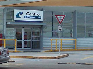
Lavington Square Shopping Centre is an enclosed sub-regional shopping centre, in Lavington, a northern suburb of Albury, New South Wales that opened in 1979. As of June 2023, the centre has 57 stores and is anchored by Big W and Woolworths. The Lavington Australia Post retail shop is also located within the centre.

Caladenia concolor, commonly known as the crimson spider orchid, is a plant in the orchid family Orchidaceae and is endemic to the south-east of Australia. It is a ground orchid with a single, sparsely hairy leaf, and one or two hairy, dark purplish-red flowers.
