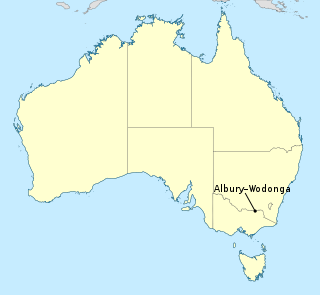
Albury–Wodonga is the broad settlement incorporating the twin Australian cities of Albury and Wodonga, which are separated geographically by the Murray River and politically by a state border: Albury on the north of the river is part of New South Wales, while Wodonga on the south bank is in Victoria.

Albury is a major regional city that is located in the Murray region of New South Wales, Australia. It is located on the Hume Highway and the northern side of the Murray River. Albury is the seat of local government for the council area which also bears the city's name – the City of Albury. It is on the Victoria–New South Wales border.

Belconnen is the most inner suburb of the larger district of Belconnen in Canberra, Australia. Sharing its name with the larger district which encapsulates it, the suburb is surrounded with well developed infrastructure, and planning which allows it sunset views from the Brindabellas on its western side. The suburb contains important amenities for the District of Belconnen including the Belconnen Town Centre and Lake Ginninderra as well as its own well populated residential areas. It is bounded by Ginninderra Drive, Aikman Drive, Eastern Valley Way, Belconnen Way and Coulter Drive. It has a number of parks such as Margaret Timpson Park, Eastern Valley Oval and on the foreshores of Lake Ginninberra, Diddams Close Park and John Knight Memorial Park.
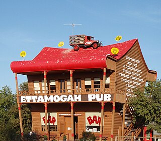
The Ettamogah Pub is a cartoon pub that was featured in the now defunct Australasian Post magazine. The cartoonist Ken Maynard, loving empty spaces and having nothing around him, enjoyed an area just outside Albury at Table Top, New South Wales, named Ettamogah, thus christening the eponymous name of his now famous pub the "Ettamogah Pub". The "Ettamogah Pub" chain of such pubs now exist in various parts of Australia including Sydney in New South Wales, and Cunderdin in Western Australia.

Lavington is the largest suburb of the city of Albury, New South Wales, located north of the Albury Central Business District. At the 2021 census, Lavington had a population of 13,073. Lavington is a mostly flat area near Nail Can Hill to the west, and is bordered by Thurgoona to the east, Hamilton Valley to the west, Springdale Heights to the north, and North Albury to the south. Lavington is mostly residential, but has significant rural areas in the north-west and a commercial area. Features include Lavington Square Shopping Centre, Lavington Swim Centre, Jelbart Park and 5 schools . Lavington is the second major centre of the City of Albury, with its own commercial CBD.
Jerrabomberra is a suburb of Queanbeyan in south eastern New South Wales, Australia. Jerrabomberra consists of three sections, The Park, The Heights, and Lakeview. The Park and the Heights are divided by Edwin Land Parkway. At the 2021 census, it had 9,601 people, up from 9,508 in 2016, 9,420 in 2011, and 8,747 in 2006. Jerrabomberra is derived from the local Aboriginal place name meaning "boy frightened by storm".

The City of Albury is a local government area in the Murray region of New South Wales, Australia. The area covers 305.9 square kilometres (118.1 sq mi) to the north of the Murray River. The area extends around 10 to 12 kilometres east and west along the river from the centre of Albury and up to 20 kilometres (12 mi) north. The population of the City of Albury area was 53,767 in June 2018.

Mullengandra is a village community in the south east part of the Riverina. It is situated by road, about 7 kilometres north east of Bowna and 8 kilometres south west of Woomargama. The town is on the Hume Highway north of Albury.
Bowna is a locality in the South East part of the Riverina, New South Wales, Australia.

Table Top is an outer suburb of the city of Albury, New South Wales, located 16 kilometres (10 mi) north of Albury and 19 kilometres (12 mi) west of Bowna. At the 2021 census, Table Top had a population of 1,516. The area used to be part of the Greater Hume Shire but was recently integrated into the City of Albury.

Thurgoona is an outer suburb of the regional city of Albury in southern New South Wales, Australia. The suburb is located in the City of Albury local government area.
West Albury is a suburb of the city of Albury, New South Wales, located 4 kilometres (2 mi) west of the Albury Central Business District. At the 2016 census, West Albury had a population of 3,851.

East Albury is a suburb of the city of Albury, New South Wales, located 3 kilometres (2 mi) east of the Albury Central Business District. At the 2006 census, East Albury had a population of 5686.
South Albury is a suburb of the city of Albury, New South Wales, located 3 kilometres (2 mi) south of the Albury Central Business District. At the 2006 census, South Albury had a population of 1102.
Glenroy is a suburb of the city of Albury, New South Wales, located northwest of the Albury Central Business District and west of Lavington. At the 2006 census, Glenroy had a population of 2659, although the area covered in the Census is considerably different from the actual area of the suburb.
Hamilton Valley is a suburb of the city of Albury, New South Wales, located north-west of the Albury Central Business District and west of Lavington. At the 2016 census, Hamilton Valley had a population of 566, although the area covered in the Census includes Splitters Creek and does not include some parts of Hamilton Valley. As a result, the population was probably closer to 450.

North Albury is a suburb of the city of Albury, New South Wales, located north of the Albury Central Business District. At the 2011 census, North Albury had a population of 5,967.
Toomulla is a coastal town and suburb in the City of Townsville, Queensland, Australia. In the 2021 census, the suburb of Toomulla had a population of 193 people.
Top Camp is a locality in the Toowoomba Region, Queensland, Australia. In the 2021 census, Top Camp had a population of 902 people.
Prince Henry Heights is a residential locality on the outskirts of Toowoomba in the Toowoomba Region, Queensland, Australia. In the 2021 census, Prince Henry Heights had a population of 600 people.
