Lavington, New South Wales

Last updated

Lavington (NSW)
Albury,  New South Wales
LavingtonUranaRoad.JPG
Urana Rd, Lavington
Lavington, New South Wales
Population13,073 (2021 census) [1]
 • Density650/km2 (1,700/sq mi)
Postcode(s) 2641
Area20 km2 (7.7 sq mi)
Location6 km (4 mi) N of Albury
LGA(s) City of Albury
State electorate(s) Albury
Federal division(s) Farrer
Suburbs around Lavington (NSW):
Table Top/Ettamogah Springdale Heights Table Top/Ettamogah
Hamilton Valley Lavington (NSW) Thurgoona
Glenroy North Albury East Albury

Lavington is the largest suburb of the city of Albury, New South Wales, located north of the Albury Central Business District. At the 2021 census, Lavington had a population of 13,073. [1] Lavington is a mostly flat area near Nail Can Hill to the west, and is bordered by Thurgoona to the east, Hamilton Valley to the west, Springdale Heights to the north, and North Albury to the south. Lavington is mostly residential, but has significant rural areas in the north-west and a commercial area. Features include Lavington Square Shopping Centre, Lavington Swim Centre, Jelbart Park and 5 schools (Lavington East Public, Lavington Public, Hume Public, Holy Spirit School (Catholic) and Murray High School). Lavington is the second major centre of the City of Albury, with its own commercial CBD.

Contents

History

Before European settlement, Aboriginals who lived in the area were of the Wiradjuri tribe. On the 15 June 1909 Lavington was officially named, having previously been known as Black Range. Once a prune-growing, orchard and gold mining area, Lavington has slowly changed to become a locality with many shops and parks. Where once the township was centred around the Lavington Hall and the Lavington Public School, near where Urana Road crosses the Bungambrawatha Creek (which has been known to yield many kinds of local crayfish or yabbies), as it became a suburb of Albury the shopping and business areas have concentrated around the junction of Griffith and Urana Roads. [2]

Lavington was formerly part of the Greater Hume Shire but was added to the City of Albury during the 1950s, with the old boundary between the two local government areas being ascribed by Union Road. Much of Albury's subsequent residential and industrial expansion has occurred in the Lavington locality, particularly after the establishment of the Albury-Wodonga Development Corporation in the early 1970s. Springdale Heights, north of Lavington was built in the 1970s and Hamilton Valley (a suburb west of Lavington) and Norris Park (a housing estate in western Lavington) were established in the 1990s. [3]

Lavington celebrated its 100th anniversary of being proclaimed a suburb on the weekend starting 13 July 2009, with community activities at Lavington Square Shopping Centre, Lavington Panthers Oval, Lavington Library and the Lavington Hall in Urana Road.[ citation needed ]

Geography

Lavington is located in the flat floodplain of the Murray River, on an area crossed by the Bungambrawatha Creek, with Nail Can Hill to the west and the Black Range to the north. Lavington is bound by Union Road to the south, the railway/freeway line to the east, Kaitlers Road to the north, and an extended Burrows Road, Reservoir Road and Urana Road to the west.

Lavington's retail and business are located primarily around Griffith Road, Wagga Road, and Urana Road. The area is served by the Lavington Square Shopping Centre formally called Centro Lavington. Currently, Woolworths and Big W is the major anchor tenants, with the Aldi relocating to the former WOW Sight and Sound building on Wagga Rd. [4]

Following the Hume Freeway Albury-Wodonga bypass, many of the business located on the former Hume Highway fell in to decline or failed. The section running through Lavington known as Wagga Road suffered the closure of many former car dealerships, petrol stations and cafes that previously relied on pass-through traffic. The local council has made efforts to beautify the area with new median strips, parking and planting with the hopes of creating a renewal for the area. [5]

Sport

There are many sporting groups in Lavington including ones for soccer, Australian rules football, cricket, netball, softball, water polo, swimming and tennis. There is a BMX and skate park.

Melrose FC [6] and Albury United SC [7] are soccer clubs who compete in the Albury Wodonga Football Association. They are one of six soccer teams located in Albury.

The Nail Can Hill Run is an annual fun run that has been going for around 30 years. The event is usually held in early May and covers a hilly cross-country course of 11.3 km starting at Lavington Panthers Club, following the ridge of hills west of Lavington, Glenroy and Albury, eventually finishing at riverside parkland in Albury. There is also a mountain bicycling race over the same course run on the same day.

The Lavington Sports Ground, located in the suburb's west, is the Albury-Wodonga region's prominent sporting venue. In addition to being the home ground of the Lavington Panthers (formerly Blues) Australian rules football club who play in the Ovens & Murray Football League, it has hosted many AFL practice matches, the England v Zimbabwe fixture in the 1992 Cricket World Cup, New South Wales v England Tour Match (cricket) in 1990, one Sheffield Shield match between NSW and Victoria in 1989, and a couple of Australian Rugby League preseason grand finals during the mid-1990s, as well as other preseason games for the ARL and NRL competitions. Up until the 1980s, the Lavington Sports Carnival, incorporating the Lavington Gift, was staged at the ground.

The John Woodman Memorial Cycling Classic finish each year in front of the Lavington Hall, Urana Road.

Residents

At the 2021 Census, the population of Lavington was 13,073, a decrease from 14,274 in 1996.

Related Research Articles

<span class="mw-page-title-main">Albury</span> City in New South Wales, Australia

Albury is a major regional city that is located in the Murray region of New South Wales, Australia. It is located on the Hume Highway and the northern side of the Murray River. Albury is the seat of local government for the council area which also bears the city's name – the City of Albury. It is on the Victoria–New South Wales border.

<span class="mw-page-title-main">Wodonga</span> Regional city in Victoria, Australia

Wodonga is a city on the Victorian side of the border with New South Wales, 324 kilometres (201 mi) north-east of Melbourne, Australia. It is located wholly within the boundaries of the City of Wodonga LGA and is separated from its twin city in New South Wales, Albury, by the Murray River. As of 2021 Wodonga and its suburbs have a population of 38,949 and combined with Albury, the two cities form the urban area Albury-Wodonga with a population of 97,793. There are multiple suburbs of Wodonga including Bandiana, Baranduda, Barnawartha, Bonegilla, Ebden, Huon Creek, Killara, Leneva and Staghorn.

<span class="mw-page-title-main">Riverina</span> Region in New South Wales, Australia

The Riverina is an agricultural region of south-western New South Wales, Australia. The Riverina is distinguished from other Australian regions by the combination of flat plains, warm to hot climate and an ample supply of water for irrigation. This combination has allowed the Riverina to develop into one of the most productive and agriculturally diverse areas of Australia. Bordered on the south by the state of Victoria and on the east by the Great Dividing Range, the Riverina covers those areas of New South Wales in the Murray and Murrumbidgee drainage zones to their confluence in the west.

<span class="mw-page-title-main">Urana</span> Town in New South Wales, Australia

Urana is a small town in the Murray region of New South Wales, Australia. The town is in the Federation Council local government area.

<span class="mw-page-title-main">Brocklesby, New South Wales</span> Town in New South Wales, Australia

Brocklesby is a town in the Murray region of south west New South Wales, Australia. The town is in the Greater Hume Shire Council local government area, 45 kilometres (28 mi) north-west of the regional centre of Albury. In the 2006 census Brocklesby had a population of 238.

<span class="mw-page-title-main">Culcairn</span> Town in New South Wales, Australia

Culcairn is a town in the south-east Murray region of New South Wales, Australia. Culcairn is located in the Greater Hume Shire local government area on the Olympic Highway between Albury and Wagga Wagga. The town is 514 kilometres (319 mi) south-west of the state capital, Sydney and at the 2016 census had a population of 1,473.

<span class="mw-page-title-main">Lavington Sports Ground</span> Mixed-use venue in Albury, Australia

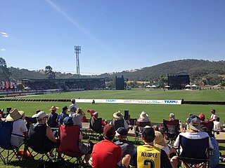
Lavington Sports Ground is a sports ground located in the suburb of Hamilton Valley near Lavington on the north-west fringe of the city of Albury, Australia. The oval is nestled in the side of a hill, with concrete terraces cut into the southern side of the oval below a grass embankment and the grandstand and changing rooms located on the north-west flank. The venue also incorporates a 4 table cricket wicket, a velodrome for track cycling and two netball courts. The Lavington Panthers Sports Club licensed club was formerly located next to the ground, across Hanna Street.

<span class="mw-page-title-main">Hume Football Netball League</span>

The Hume Australian Football Netball League (HFNL), often shortened to Hume Football League, is an Australian rules football and netball competition containing twelve clubs based in the South West Slopes and southern Riverina regions of New South Wales, Australia. The league features four grades in the Australian rules football competition, with these being First-Grade, Reserve-Grade, Under 17s and Under 14s. In the netball competition, there are six grades, with these being A-Grade, B-Grade, C-Grade, C-Reserve Grade, Intermediates and Juniors.

<span class="mw-page-title-main">City of Albury</span> Local government area in New South Wales, Australia

The City of Albury is a local government area in the Murray region of New South Wales, Australia. The area covers 305.9 square kilometres (118.1 sq mi) to the north of the Murray River. The area extends around 10 to 12 kilometres east and west along the river from the centre of Albury and up to 20 kilometres (12 mi) north. The population of the City of Albury area was 53,767 in June 2018.

<span class="mw-page-title-main">Thurgoona, New South Wales</span> Suburb of Albury, New South Wales, Australia

Thurgoona is an outer suburb of the regional city of Albury in southern New South Wales, Australia. The suburb is located in the City of Albury local government area.

West Albury is a suburb of the city of Albury, New South Wales, located 4 kilometres (2 mi) west of the Albury Central Business District. At the 2016 census, West Albury had a population of 3,851.

<span class="mw-page-title-main">East Albury, New South Wales</span> Suburb of Albury, New South Wales, Australia

East Albury is a suburb of the city of Albury, New South Wales, located 3 kilometres (2 mi) east of the Albury Central Business District. At the 2006 census, East Albury had a population of 5686.

South Albury is a suburb of the city of Albury, New South Wales, located 3 kilometres (2 mi) south of the Albury Central Business District. At the 2006 census, South Albury had a population of 1102.

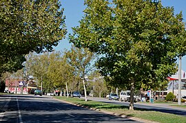
Glenroy is a suburb of the city of Albury, New South Wales, located northwest of the Albury Central Business District and west of Lavington. At the 2006 census, Glenroy had a population of 2659, although the area covered in the Census is considerably different from the actual area of the suburb.

Hamilton Valley is a suburb of the city of Albury, New South Wales, located north-west of the Albury Central Business District and west of Lavington. At the 2016 census, Hamilton Valley had a population of 566, although the area covered in the Census includes Splitters Creek and does not include some parts of Hamilton Valley. As a result, the population was probably closer to 450.

<span class="mw-page-title-main">North Albury, New South Wales</span> Suburb of Albury, New South Wales, Australia

North Albury is a suburb of the city of Albury, New South Wales, located north of the Albury Central Business District. At the 2011 census, North Albury had a population of 5,967.

Springdale Heights is a suburb of the city of Albury, New South Wales, located north of the Albury Central Business District and north of Lavington At the 2006 census, Springdale Heights had a population of 1761, although the area covered in the Census includes parts of Table Top.

The John Woodman Memorial, otherwise known as the Wagga to Albury, is an annual bicycle handicap race that runs between the New South Wales cities of Wagga Wagga and Albury. The event was first run in the 1930s, leaving the Wagga Railway Station and travelling via Tarcutta and Holbrook to finish outside the Globe Hotel in Albury. In 1948 the race was changed to run via the Olympic Way and finish in Dean St. It ran this way until its conclusion in 1963. In 1987 the event was revived and has run every year since. The event is organised by the Albury Wodonga Cycling Club (AWCC) and for 2013, the race will be held on 28 July.
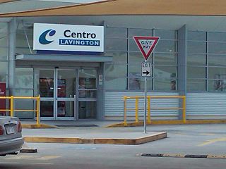
Country Cricket New South Wales is responsible for the development of cricket in regional New South Wales. It is under control of the governing body Cricket NSW.

<span class="mw-page-title-main">Urana Soldiers' Memorial Hall</span> Historic site in New South Wales, Australia

The Urana Soldiers' Memorial Hall is a heritage-listed community hall located at Anna Street, Urana, Federation Council, New South Wales, Australia. It was designed by George Sheppard and by Sidney James Hunnings. The Hall was built between 1884 and 1924. It is also known as the Soldiers Hall, Mechanics Institute Hall and School of Arts Hall. The property is owned by Federation Council. It was added to the New South Wales State Heritage Register on 8 April 2016.

References

  1. 1 2 3 "2021 Lavington, Census All persons QuickStats | Australian Bureau of Statistics".
  2. "Lavington celebrates". www.abc.net.au. 16 June 2009. Retrieved 23 November 2017.
  3. Stein, Clara (2012). "The growth and development of Albury-Wodonga 1972-2006: united and divided". Macquarie University ResearchOnline.
  4. JOHNSTON, DAVID (5 April 2014). "Wow! Aldi lines up a new store". The Border Mail. Retrieved 22 November 2017.
  5. JOHNSTON, DAVID (10 March 2017). "Funding bid for Wagga Road". The Border Mail. Retrieved 22 November 2017.
  6. https://www.facebook.com/melrosefootballclub/ [ user-generated source ]
  7. https://www.facebook.com/AlburyUnited/?ref=br_rs [ user-generated source ]

Commons-logo.svg Media related to Lavington, New South Wales at Wikimedia Commons

36°03′00″S146°55′59″E / 36.05°S 146.933°E / -36.05; 146.933