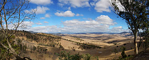
The Shire of Towong is a local government area in the Hume region of Victoria, Australia, located in the north-east part of the state. It covers an area of 6,673 square kilometres (2,576 sq mi) and at the 2016 Census had a population of approximately 6,000.

Omeo is a town in Victoria, Australia on the Great Alpine Road, east of Mount Hotham, in the Shire of East Gippsland. At the 2016 census, Omeo had a population of 406. The name is derived from the Aboriginal word for 'mountains' or 'hills'. Omeo is affectionately known as the City of the Alps with many historic buildings remaining in the town. The town is still the commercial hub for the Omeo Region and is a service centre for outlying communities such as Benambra, Cobungra, Cassilis, Swifts Creek, and Ensay.

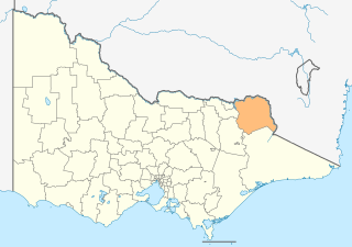
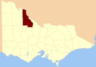
The County of Bogong is one of the 37 counties of Victoria which are part of the cadastral divisions of Australia, used for land titles. It is located south of the Murray River, east of the Ovens River, and west of the Mitta Mitta River. Mount Bogong is located there, the highest mountain in Victoria. The county was proclaimed in 1871.

The County of Bendigo is one of the 37 counties of Victoria which are part of the cadastral divisions of Australia, used for land titles. It includes the city of Bendigo. It is bounded by the Campaspe River in the east, and the Loddon River in the west. The county was proclaimed in 1869.

The County of Dalhousie is one of the 37 counties of Victoria which are part of the cadastral divisions of Australia, used for land titles. It is located to the north of Melbourne. It is bounded by the Coliban River to the west. The Goulburn River forms part of the boundary to the north-east. Puckapunyal is on its northern edge, and Kilmore and Woodend on its southern edge. The county was proclaimed in 1849.

The County of Dargo is one of the 37 counties of Victoria which are part of the cadastral divisions of Australia, used for land titles. It is located in Gippsland, between the Mitchell River in the west and the Tambo River in the east. Lake King is on the southern edge. It was gazetted in 1871. Earlier maps show the area as being part of a proposed County of Abinger.

The County of Croajingolong is one of the 37 counties of Victoria which are part of the cadastral divisions of Australia, used for land titles. It is the most easterly county, and includes the Croajingolong National Park. Its western boundary is the Snowy River. The county was proclaimed in 1871 together with others from the Gipps Land District. Some time earlier maps showed proposed counties of Howe and Combermere occupying the area of Croajingolong.

The County of Rodney is one of the 37 counties of Victoria which are part of the cadastral divisions of Australia, used for land titles. It is located between the Goulburn River in the east, and the Campaspe River in the west, with a small part of the Murray River to the north. Puckapunyal is near its southern edge. The former electoral district of Rodney was in a similar area.
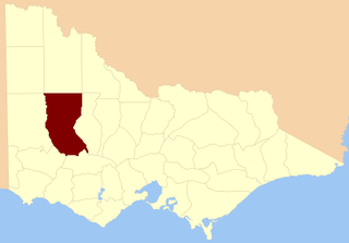
The County of Tatchera is one of the 37 counties of Victoria which are part of the cadastral divisions of Australia, used for land titles. It is located to the south of the Murray River, and to the south west of Swan Hill, with its western boundary at 143°E, and part of the southern boundary at 36°S.
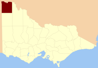
The County of Millewa is one of the 37 counties of Victoria which are part of the cadastral divisions of Australia, used for land titles. It is located to the south of the Murray River, at the north-western corner of Victoria, with the South Australian border to the west. This border was originally intended to be at the 141st meridian of longitude, but because of the South Australia-Victoria border dispute it is several miles to the west of it. The southern boundary of the county is at 35°S, and the eastern at 142°E. The name is also used for the region.

The Shire of Tallangatta was a local government area about 340 kilometres (211 mi) northeast of Melbourne, the state capital of Victoria, Australia. The shire covered an area of 4,090.72 square kilometres (1,579.4 sq mi), and existed from 1869 until 1994.

The High Country Rail Trail is a 35 kilometre, part-gravel part-sealed rail trail on the northern border of Victoria, Australia. It runs along the former Cudgewa railway line from Wodonga, along the edge of Lake Hume, to a point just east of the Mitta Mitta River, including a 600-metre bridge over Sandy Creek Inlet. There are plans to eventually extend the trail as far as Cudgewa near Corryong.

The County of Lowan is one of the 37 counties of Victoria which are part of the cadastral divisions of Australia, used for land titles. The northern boundary of the county is at 36°S. Larger towns include Dimboola, Edenhope and Kaniva. The county was proclaimed in 1871 together with the other counties of the Wimmera Land District.

The County of Polwarth is one of the 37 counties of Victoria which are part of the cadastral divisions of Australia, used for land titles. The county is in the Western District of Victoria and includes the Cape Otway area, bounded by the Gellibrand River in the west and the Anglesea River and Barwon River in the east, in the north by a line from Winchelsea, through Colac to Larpent, and by Bass Strait to the south. The largest town is Colac. The county was proclaimed in 1849.

The Cobberas Range, a mountain range that is part of the Great Dividing Range within the Victorian Alps, is located in north-eastern Victoria in Australia. The range is located in the Cobberas Wilderness area of the Alpine National Park.
The electoral district of Borung was an electorate of the Victorian Legislative Assembly in the Australian colony of Victoria, which existed in two incarnations, from 1889 to 1927, and then from 1945 to 1955.
Mitta Airport is a small Australian rural airport which serves the town of Mitta Mitta in Victoria's northeast. The 910m gravel runway is parallel to the Omeo Highway 1.5 nm north east of Mitta Mitta. The airport is used by air ambulances, pilot training flights, fire fighting and for visitors to the area.
The Dart River, a perennial river of the North-East Murray catchment of the Murray-Darling basin, is located in the alpine region of Victoria, Australia. It flows from the northwestern slopes of the Alpine National Park in the Australian Alps, south and joins with the Mitta Mitta River within Lake Dartmouth.
The Gibbo River, a perennial river of the North-East Murray catchment of the Murray-Darling basin, is located in the alpine and East Gippsland regions of Victoria, Australia. It flows from the northwestern slopes of the Australian Alps, south and joins with Morass Creek southeast of Lake Dartmouth.