County of Bourke, Victoria

Last updated
Bourke
Victoria
Bourke Victoria.png
Location in Victoria
Lands administrative divisions around Bourke:
Talbot Dalhousie Anglesey
Grant Bourke Evelyn
Grant Port Phillip Mornington
1866 map of Bourke County showing the parishes Bourke County 1866.jpg
1866 map of Bourke County showing the parishes
1885 map of Bourke County (pink) Bourke County 1885.jpg
1885 map of Bourke County (pink)
1886 map of Bourke County Bourke County 1886.jpg
1886 map of Bourke County

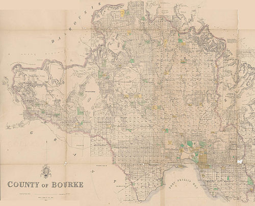
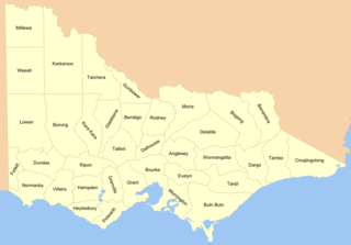
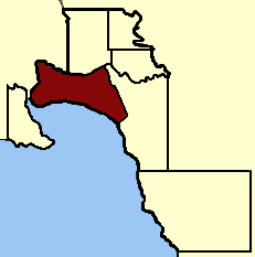
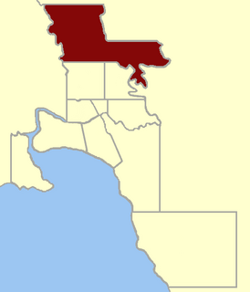
The County of Bourke is one of the 37 counties of Victoria which are part of the Lands administrative divisions of Australia, used for land titles. It is the oldest and most populous county in Victoria and contains the city of Melbourne. Like other counties in Victoria, it is subdivided into parishes. The county was named after General Sir Richard Bourke, the Governor of New South Wales between 1831 and 1837. [1] It is bordered by the Werribee River in the west, the Great Dividing Range in the north, Port Phillip in the south, and by Dandenong Creek, a small part of the Yarra River, and the Plenty River in the east. The county was proclaimed in 1853.

Lands administrative divisions of Australia

Lands administrative divisions of Australia are the cadastral divisions of Australia for the purposes of identification of land to ensure security of land ownership. Most states term these divisions as counties, parishes, hundreds, and other terms. The eastern states of Queensland, New South Wales, Victoria and Tasmania were divided into counties and parishes in the 19th century, although the Tasmanian counties were renamed land districts in the 20th century. Parts of South Australia (south-east) and Western Australia (south-west) were similarly divided into counties, and there were also five counties in a small part of the Northern Territory. However South Australia has subdivisions of hundreds instead of parishes, along with the Northern Territory, which was part of South Australia when the hundreds were proclaimed. There were also formerly hundreds in Tasmania. There have been at least 600 counties, 544 hundreds and at least 15,692 parishes in Australia, but there are none of these units for most of the sparsely inhabited central and western parts of the country.

Victoria (Australia) State in Australia

Victoria is a state in south-eastern Australia. Victoria is Australia's smallest mainland state and its second-most populous state overall, making it the most densely populated state overall. Most of its population lives concentrated in the area surrounding Port Phillip Bay, which includes the metropolitan area of its state capital and largest city, Melbourne, Australia's second-largest city. Victoria is bordered by Bass Strait and Tasmania to the south, New South Wales to the north, the Tasman Sea to the east, and South Australia to the west.

Melbourne City in Victoria, Australia

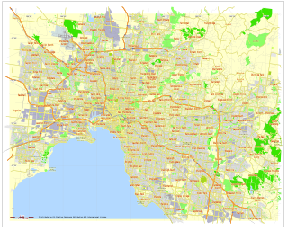
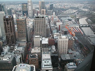
Melbourne is the capital and most populous city of the Australian state of Victoria, and the second most populous city in Australia and Oceania. Its name refers to an urban agglomeration of 2,080.5 km2 (803.3 sq mi), comprising a metropolitan area with 31 municipalities, and is also the common name for its city centre. The city occupies much of the coastline of Port Phillip bay and spreads into the hinterlands towards the Dandenong and Macedon ranges, Mornington Peninsula and Yarra Valley. It has a population of approximately 5 million, and its inhabitants are referred to as "Melburnians".

Contents

Unlike counties in England and in the United States, Australian counties serve no administrative or political function. Rather, counties exist for purposes of land ownership. For example, property titles in Lands administrative divisions of Australia are often listed as being situated within a parish and county. For political subdivisions, Australia employs the Local Government Area (LGA) system — which includes shires, districts, and city councils — as the third and lowest tier of government (the States and territories of Australia being the second tier and the Federal Government being the highest tier).

Counties of England Englands administrative, geographical and political demarcation

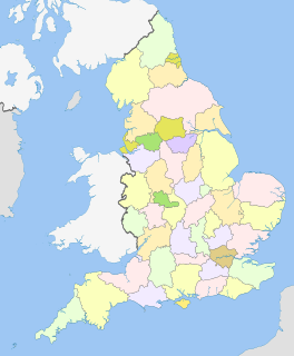
The counties of England are areas used for different purposes, which include administrative, geographical, cultural and political demarcation. The term 'county' is not clearly defined and can apply to similar or the same areas used by each of these demarcation structures. These different types of county each have a more formal name but are commonly referred to just as 'counties'. The current arrangement is the result of incremental reform.

County (United States) Subdivision used by most states in the United States of America

In the United States, a county is an administrative or political subdivision of a state that consists of a geographic region with specific boundaries and usually some level of governmental authority. The term "county" is used in 48 U.S. states, while Louisiana and Alaska have functionally equivalent subdivisions called parishes and boroughs, respectively.

Local government in Australia

Local government in Australia is the third tier of government in Australia administered by the states and territories, which in turn are beneath the federal tier. Local government is not mentioned in the Constitution of Australia and two referenda in the 1970s and 1980s to alter the Constitution relating to local government were unsuccessful. Every state government recognises local government in their respective constitutions. Unlike Canada or the United States, there is only one level of local government in each state, with no distinction such as cities and counties.

The Melbourne and County of Bourke Police was the name for the police force in the area before 1853. The County of Bourke was used on the name of the electoral roll in 1845. [2] There was also the Bourke County Court in the 1850s, [3] which became the County Court of Victoria. Melbourne is also referenced as being in "Bourke county" in the Encyclopædia Britannica Eleventh Edition . [4]

County Court of Victoria principal trial court of the state of Victoria, Australia

The County Court of Victoria is the principal trial court in Victoria, with approximately 70 judges hearing up to 12,000 cases annually.

<i>Encyclopædia Britannica</i> Eleventh Edition 11th edition of Encyclopædia Britannica

The Encyclopædia Britannica, Eleventh Edition (1910–11), is a 29-volume reference work, an edition of the Encyclopædia Britannica. It was developed during the encyclopaedia's transition from a British to an American publication. Some of its articles were written by the best-known scholars of the time. This edition of the encyclopedia, containing 40,000 entries, is now in the public domain, and many of its articles have been used as a basis for articles in Wikipedia. However, the outdated nature of some of its content makes its use as a source for modern scholarship problematic. Some articles have special value and interest to modern scholars as cultural artifacts of the 19th and early 20th centuries.

Parishes

Map all coordinates using: OpenStreetMap  
Download coordinates as: KML  ·  GPX

Following is a list of parishes within the County of Bourke. Many of the links below link to a modern suburb or town, which is situated within the parish. In most cases, the parish itself is much bigger than the modern suburb or town.

Several of the parishes are also part of a neighbouring county. For example, Bylands, Forbes, Goldie, Lancefield and Newham parishes are located in the County of Bourke as well as the County of Dalhousie. Morang, Toorourrong and Yan Yean parishes are in the County of Bourke as well as the County of Evelyn. Finally, Ballan parish is situated within both the County of Bourke and the County of Grant.

Lancefield, Victoria Town in Victoria, Australia

Lancefield is a town in the Shire of Macedon Ranges local government area in Victoria, Australia 69 kilometres (43 mi) north of the state capital, Melbourne and had a population of 2,357 at the 2011 census.

County of Dalhousie, Victoria Cadastral in Victoria, Australia

The County of Dalhousie is one of the 37 counties of Victoria which are part of the cadastral divisions of Australia, used for land titles. It is located to the north of Melbourne. It is bounded by the Coliban River to the west. The Goulburn River forms part of the boundary to the north-east. Puckapunyal is on its northern edge, and Kilmore and Woodend on its southern edge. The county was proclaimed in 1849.

County of Evelyn, Victoria Cadastral in Victoria, Australia

The County of Evelyn is one of the 37 counties of Victoria which are part of the cadastral divisions of Australia, used for land titles. It is located to the east of Melbourne, on both sides of the upper reaches of the Yarra River in the Yarra Valley. The Great Dividing Range is the boundary to the north. The county was proclaimed in 1849.

ParishLGACoordinatesRefMap
Blackwood Shire of Moorabool 37°29′57″S144°19′25″E / 37.49917°S 144.32361°E / -37.49917; 144.32361 (Blackwood) Vicnames
Bollinda City of Hume 37°31′57″S144°47′59″E / 37.53250°S 144.79972°E / -37.53250; 144.79972 (Bollinda) Vicnames
Boroondara City of Boroondara 37°48′47″S145°04′04″E / 37.81306°S 145.06778°E / -37.81306; 145.06778 (Boroondara) Vicnames
Bulla Bulla City of Hume 37°36′05″S144°48′42″E / 37.60139°S 144.81167°E / -37.60139; 144.81167 (Bulla Bulla) Vicnames
Bulleen City of Manningham 37°45′59″S145°09′11″E / 37.76639°S 145.15306°E / -37.76639; 145.15306 (Bulleen) Vicnames
Bullengarook Shire of Macedon Ranges 37°30′22″S144°30′49″E / 37.50611°S 144.51361°E / -37.50611; 144.51361 (Bullengarook) Vicnames
Buttlejorrk City of Hume 37°32′09″S144°41′21″E / 37.53583°S 144.68917°E / -37.53583; 144.68917 (Buttlejorrk) Vicnames
Bylands Shire of Mitchell 37°20′44″S144°58′25″E / 37.34556°S 144.97361°E / -37.34556; 144.97361 (Bylands) Vicnames
Chintin Shire of Macedon Ranges 37°22′36″S144°51′11″E / 37.37667°S 144.85306°E / -37.37667; 144.85306 (Chintin) Vicnames
Coimadai Shire of Moorabool 37°34′34″S144°27′25″E / 37.57611°S 144.45694°E / -37.57611; 144.45694 (Coimadai) Vicnames
Coornmill Shire of Moorabool 37°29′20″S144°25′33″E / 37.48889°S 144.42583°E / -37.48889; 144.42583 (Coornmill) Vicnames
Cut Paw Paw City of Maribyrnong 37°48′32″S144°52′29″E / 37.80889°S 144.87472°E / -37.80889; 144.87472 (Cut Paw Paw) Vicnames
Dandenong City of Greater Dandenong 37°58′18″S145°11′28″E / 37.97167°S 145.19111°E / -37.97167; 145.19111 (Dandenong) Vicnames
Darraweit Guim Shire of Macedon Ranges 37°28′00″S144°53′41″E / 37.46667°S 144.89472°E / -37.46667; 144.89472 (Darraweit Guim) Vicnames
Derrimut City of Melton 37°46′46″S144°45′03″E / 37.77944°S 144.75083°E / -37.77944; 144.75083 (Derrimut) Vicnames
Deutgam City of Wyndham 37°55′17″S144°43′42″E / 37.92139°S 144.72833°E / -37.92139; 144.72833 (Deutgam) Vicnames
Djerriwarrh City of Melton 37°40′36″S144°33′44″E / 37.67667°S 144.56222°E / -37.67667; 144.56222 (Djerriwarrh) Vicnames
Doutta Galla City of Moonee Valley 37°44′56″S144°54′30″E / 37.74889°S 144.90833°E / -37.74889; 144.90833 (Doutta Galla) Vicnames
Forbes Shire of Mitchell 37°18′48″S144°53′16″E / 37.31333°S 144.88778°E / -37.31333; 144.88778 (Forbes) Vicnames
Gisborne Shire of Macedon Ranges 37°29′04″S144°36′01″E / 37.48444°S 144.60028°E / -37.48444; 144.60028 (Gisborne) Vicnames
Goldie Shire of Macedon Ranges 37°14′31″S144°49′32″E / 37.24194°S 144.82556°E / -37.24194; 144.82556 (Goldie) Vicnames
Jika Jika City of Darebin 37°45′02″S144°59′28″E / 37.75056°S 144.99111°E / -37.75056; 144.99111 (Jika Jika) Vicnames
Havelock Shire of Macedon Ranges 37°27′16″S144°48′53″E / 37.45444°S 144.81472°E / -37.45444; 144.81472 (Havelock) Vicnames
Holden City of Melton 37°37′06″S144°42′29″E / 37.61833°S 144.70806°E / -37.61833; 144.70806 (Holden) Vicnames
Jika Jika City of Whittlesea 37°45′02″S144°59′28″E / 37.75056°S 144.99111°E / -37.75056; 144.99111 (Jika Jika) Vicnames
Kalkallo City of Whittlesea 37°33′02″S144°59′51″E / 37.55056°S 144.99750°E / -37.55056; 144.99750 (Kalkallo) Vicnames
Keelbundora City of Darebin 37°42′53″S145°03′45″E / 37.71472°S 145.06250°E / -37.71472; 145.06250 (Keelbundora) Vicnames
Kerrie Shire of Macedon Ranges 37°26′00″S144°41′44″E / 37.43333°S 144.69556°E / -37.43333; 144.69556 (Kerrie) Vicnames
Korkuperrimul Shire of Moorabool 37°39′09″S144°24′08″E / 37.65250°S 144.40222°E / -37.65250; 144.40222 (Korkuperrimul) Vicnames
Kororoit City of Melton 37°41′50″S144°38′48″E / 37.69722°S 144.64667°E / -37.69722; 144.64667 (Kororoit) Vicnames
Lancefield Shire of Macedon Ranges 37°17′01″S144°44′47″E / 37.28361°S 144.74639°E / -37.28361; 144.74639 (Lancefield) Vicnames
Macedon Shire of Macedon Ranges 37°24′36″S144°33′51″E / 37.41000°S 144.56417°E / -37.41000; 144.56417 (Macedon) Vicnames
Maribyrnong City of Brimbank 37°42′45″S144°46′40″E / 37.71250°S 144.77778°E / -37.71250; 144.77778 (Maribyrnong) Vicnames
Melbourne North City of Yarra 37°47′59″S144°58′46″E / 37.79972°S 144.97944°E / -37.79972; 144.97944 (Melbourne North) Vicnames
Melbourne South City of Port Phillip 37°50′11″S144°57′25″E / 37.83639°S 144.95694°E / -37.83639; 144.95694 (Melbourne South) Vicnames
Merriang City of Whittlesea 37°28′46″S145°00′27″E / 37.47944°S 145.00750°E / -37.47944; 145.00750 (Merriang) Vicnames
Merrimu Shire of Moorabool 37°39′13″S144°29′34″E / 37.65361°S 144.49278°E / -37.65361; 144.49278 (Merrimu) Vicnames
Mickleham City of Hume 37°32′26″S144°53′50″E / 37.54056°S 144.89722°E / -37.54056; 144.89722 (Mickleham) Vicnames
Monegeetta Shire of Macedon Ranges 37°22′46″S144°45′34″E / 37.37944°S 144.75944°E / -37.37944; 144.75944 (Monegeetta) Vicnames
Moorabbin City of Kingston 37°56′29″S145°02′30″E / 37.94139°S 145.04167°E / -37.94139; 145.04167 (Moorabbin) Vicnames
Moorarbool East Shire of Moorabool 37°29′49″S144°13′11″E / 37.49694°S 144.21972°E / -37.49694; 144.21972 (Moorarbool East) Vicnames
Morang City of Whittlesea 37°38′09″S145°05′26″E / 37.63583°S 145.09056°E / -37.63583; 145.09056 (Morang) Vicnames
Mordialloc City of Kingston 37°57′32″S145°07′15″E / 37.95889°S 145.12083°E / -37.95889; 145.12083 (Mordialloc) Vicnames
Mulgrave City of Monash 37°53′18″S145°08′52″E / 37.88833°S 145.14778°E / -37.88833; 145.14778 (Mulgrave) Vicnames
Myrniong Shire of Moorabool 37°36′32″S144°20′37″E / 37.60889°S 144.34361°E / -37.60889; 144.34361 (Myrniong) Vicnames
Nunawading City of Whitehorse 37°49′41″S145°09′54″E / 37.82806°S 145.16500°E / -37.82806; 145.16500 (Nunawading) Vicnames
Prahran City of Glen Eira 37°52′38″S145°02′28″E / 37.87722°S 145.04111°E / -37.87722; 145.04111 (Prahran) Vicnames
Pywheitjorrk City of Melton 37°46′09″S144°38′19″E / 37.76917°S 144.63861°E / -37.76917; 144.63861 (Pywheitjorrk) Vicnames
Rochford Shire of Macedon Ranges 37°18′44″S144°40′53″E / 37.31222°S 144.68139°E / -37.31222; 144.68139 (Rochford) Vicnames
Springfield Shire of Macedon Ranges 37°19′29″S144°48′55″E / 37.32472°S 144.81528°E / -37.32472; 144.81528 (Springfield) Vicnames
Tarneit City of Wyndham 37°50′47″S144°40′38″E / 37.84639°S 144.67722°E / -37.84639; 144.67722 (Tarneit) Vicnames
Toorourrong City of Whittlesea 37°29′31″S145°06′52″E / 37.49194°S 145.11444°E / -37.49194; 145.11444 (Toorourrong) Vicnames
Truganina City of Hobsons Bay 37°51′01″S144°47′06″E / 37.85028°S 144.78500°E / -37.85028; 144.78500 (Truganina) Vicnames
Tullamarine City of Hume 37°40′33″S144°50′45″E / 37.67583°S 144.84583°E / -37.67583; 144.84583 (Tullamarine) Vicnames
Wallan Wallan Shire of Mitchell 37°25′22″S145°03′43″E / 37.42278°S 145.06194°E / -37.42278; 145.06194 (Wallan Wallan) Vicnames
Will Will Rook City of Hume 37°41′15″S144°56′30″E / 37.68750°S 144.94167°E / -37.68750; 144.94167 (Will Will Rook) Vicnames
Wollert City of Whittlesea 37°37′28″S145°00′05″E / 37.62444°S 145.00139°E / -37.62444; 145.00139 (Wollert) Vicnames
Yangardook City of Melton 37°36′02″S144°35′35″E / 37.60056°S 144.59306°E / -37.60056; 144.59306 (Yangardook) Vicnames
Yuroke City of Hume 37°36′53″S144°54′35″E / 37.61472°S 144.90972°E / -37.61472; 144.90972 (Yuroke) Vicnames

See also

Related Research Articles

Cadastral divisions of Victoria land administration division of Victoria, Australia

Cadastral divisions in Victoria are called counties, which are further subdivided into parishes and townships, for cadastral or land administration purposes. Cadastral divisions of county, parish and township form the basis for formal identification of the location of any piece of land in the state. There are 37 counties and 2004 parishes and 909 townships. Parishes were subdivided into sections of various sizes for sale as farming allotments, or designated as a town and then divided into sections and these subdivided into crown allotments. However, many parishes do not follow county borders, some being located in more than one county.

Hoddle Grid layout of the Melbourne central business district

The Hoddle Grid is the contemporary name given to the approximately 1-by-0.5-mile grid of streets that form the central business district of Melbourne Australia. Bounded by Flinders Street, Spring Street, La Trobe Street, and Spencer Street, it lies at an angle to the rest of the Melbourne suburban grid, and so is easily recognisable. It is named after the surveyor Robert Hoddle, who marked it out in 1837, establishing the first formal town plan. This grid of streets, laid out when there were only a few hundred settlers, became the nucleus for what is now a city of over 5 million people, the city of Melbourne.

Oakleigh, Victoria Suburb of Melbourne, Victoria, Australia

Oakleigh is a suburb of Melbourne, Victoria, Australia 14 km south-east of Melbourne's central business district. Its local government area is the City of Monash. At the 2016 Census, Oakleigh had a population of 7,893.

William Street, Melbourne street in Melbourne, Victoria

William Street is a major street in the central business district of Melbourne, Victoria, Australia. It runs roughly north-south from Flinders Street to Victoria Street, and was laid out in 1837 as part of the original Hoddle Grid. The street is located in-between King Street and Queen Street.

Ripponlea, Victoria Suburb of Melbourne, Victoria, Australia

Ripponlea is an inner suburb of Melbourne, Victoria, Australia, named after the adjoining Rippon Lea Estate. It is 7 km south east of Melbourne's Central Business District. Its local government area is the City of Port Phillip. At the 2011 Census, Ripponlea had a population of 1,478.

Melbourne City Centre Suburb of Melbourne, Victoria, Australia

Melbourne City Centre is an area of Melbourne, Victoria, Australia. It is the area in which Melbourne was established in 1835, by John Batman and John Pascoe Fawkner, and its boundaries are defined by the Government of Victoria's Melbourne Planning Scheme. Today it comprises the two oldest areas of Melbourne; the Hoddle Grid and Queen Victoria Market, as well as sections of the redeveloped areas of Docklands and Southbank/South Wharf. It is not to be confused with the larger local government area of the City of Melbourne.

County of Grant, Victoria Cadastral in Victoria, Australia

The County of Grant is one of the 37 counties of Victoria which are part of the cadastral divisions of Australia, used for land titles. It is located to the west of Melbourne, on the west side of Port Phillip and includes Geelong. Ballarat is on its north-western edge. It is bounded in the west by the Yarrowee River, on the north by the Great Dividing Range and on the east by the Werribee River. The county was proclaimed in 1853.

Electoral district of South Melbourne

Electoral district of South Melbourne was an electoral district of the Legislative Assembly in the British colony of Victoria (Australia).

Electoral district of Tullamarine was an electoral district of the Legislative Assembly in the Australian state of Victoria. The district centred on the suburb of Tullamarine, about 17 km north-west of Melbourne.

Unwins Special Survey

In 1841, Frederic Wright Unwin, a Sydney solicitor, purchased 5,120 acres or eight square miles of land approximately 10 km north-east of Melbourne, Victoria, Australia. The land was purchased from the Crown for one pound an acre under the terms of the short-lived Special Survey regulations.

Electoral district of Collingwood former state electoral district of Victoria, Australia

Collingwood was an electoral district of the Legislative Assembly in the Australian state of Victoria from 1856 to 1958. It centred on the Melbourne suburb of Collingwood, Victoria.

Electoral district of West Bourke former electoral district of Victoria

West Bourke was an electoral district of the Legislative Assembly in the Australian state of Victoria from 1856 to 1904.

Electoral district of East Bourke Boroughs state electoral district of Victoria, Australia

East Bourke Boroughs was an electoral district of the Legislative Assembly in the Australian state of Victoria from 1859 to 1904.

Electoral district of Grant (Victorian Legislative Council)

The Electoral district of Grant was one of the sixteen electoral districts of the original unicameral Victorian Legislative Council (Australia) of 1851 to 1856.

Electoral district of City of Melbourne

The Electoral district of City of Melbourne was one of the original sixteen electoral districts of the old unicameral Victorian Legislative Council of 1851 to 1856; Victoria having been made a separate colony in Australia in the former year.

Electoral district of North Bourke

The Electoral district of North Bourke was one of the original sixteen electoral districts of the old unicameral Victorian Legislative Council of 1851 to 1856. Victoria being a colony in Australia at the time.

Electoral district of Talbot, Dalhousie and Angelsey

The Electoral district of Talbot, Dalhousie and Angelsey was one of the original sixteen electoral districts of the old unicameral Victorian Legislative Council of 1851 to 1856. Victoria being a colony in Australia at the time.

Cobblebank Suburb of City of Melton, Victoria, Australia

Cobblebank is a developing outer suburb located 31km west of the CBD of Melbourne, Victoria, Australia. Its local government area is the City of Melton. The suburb was gazetted by the Office of Geographic Names on 9 February 2017, following a proposal for eleven new suburbs by the City of Melton. The new name officially came into effect in mid-2017. Prior to the suburb's creation, the area was part of Melton South.

References

  1. Bourke street Melbourne Archived 2006-10-03 at the Wayback Machine
  2. State Library of Tasmania, Electoral Rolls
  3. Bourke County Court
  4. Chisholm, Hugh, ed. (1911). "Melbourne"  . Encyclopædia Britannica . 18 (11th ed.). Cambridge University Press. p. 90.

Coordinates: 37°35′S144°50′E / 37.583°S 144.833°E / -37.583; 144.833

Geographic coordinate system Coordinate system

A geographic coordinate system is a coordinate system that enables every location on Earth to be specified by a set of numbers, letters or symbols. The coordinates are often chosen such that one of the numbers represents a vertical position and two or three of the numbers represent a horizontal position; alternatively, a geographic position may be expressed in a combined three-dimensional Cartesian vector. A common choice of coordinates is latitude, longitude and elevation. To specify a location on a plane requires a map projection.