
Mickleham is a suburb of Melbourne, Victoria, Australia, 29 km (18 mi) north of Melbourne's central business district, located within the City of Hume local government area and beyond the Urban Growth Boundary. Mickleham recorded a population of 17,452 at the 2021 census, compared to 3,142 at the 2016 census. In 2018, it was covered by the Australian Broadcasting Corporation as Australia's fastest-growing suburb.

Binda is a village in the Southern Tablelands region of New South Wales, Australia in Upper Lachlan Shire.

The Shire of Yilgarn is a local government area in the eastern Wheatbelt region of Western Australia about 400 kilometres (250 mi) east of Perth, the state capital. The Shire covers an area of 30,720 square kilometres (11,860 sq mi) and its seat of government is the town of Southern Cross. The main industries within the Shire are mining and farming.

The Shire of Mount Marshall is a local government area in the Wheatbelt region of Western Australia, about 80 kilometres (50 mi) north-northwest of Merredin and about 300 kilometres (186 mi) northeast of the state capital, Perth. The Shire covers an area of 10,190 square kilometres (3,934 sq mi), and its seat of government is the town of Bencubbin.

Newham is a town in the Shire of Macedon Ranges in Victoria, Australia. It is situated between the towns of Kyneton, Woodend and Lancefield. At the 2006 census, the surrounding area had a population of 570. At the 2016 census, Newham and the surrounding area had a population of 506.

The Shire of Murray is a local government area of Western Australia. It has an area of 1,710.1 square kilometres (660.3 sq mi) and is located in the Peel Region about 80 kilometres (50 mi) south of the Perth CBD.
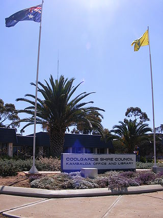
The Shire of Coolgardie is a local government area in the Goldfields–Esperance region of Western Australia, lying roughly west and south of the city of Kalgoorlie. The Shire covers an area of 30,400 square kilometres (11,738 sq mi), and its seat of government is the town of Coolgardie, although the twin towns of Kambalda East and Kambalda West contain two-thirds of the Shire's population.

The Shire of Boddington is a local government area in the Peel region of Western Australia, about 120 kilometres (75 mi) south-east of the state capital, Perth. The Shire covers an area of 1,901 square kilometres (734 sq mi), and its seat of government is the town of Boddington.

The Shire of Wagin is a local government area in the Wheatbelt region of Western Australia, about 230 kilometres (143 mi) southeast of the state capital, Perth. The Shire covers an area of about 1,948 square kilometres (752 sq mi), and its seat of government is the town of Wagin.

Monegeetta is a town north of Melbourne, Australia between the major towns of Sunbury and Romsey in fertile agricultural land east of the Macedon Ranges. Its local government area is the Shire of Macedon Ranges.

The Shire of Mukinbudin is a local government area in the Wheatbelt region of Western Australia, about 80 kilometres (50 mi) north of Merredin and about 300 kilometres (186 mi) east of the state capital, Perth. The Shire covers an area of 3,437 square kilometres (1,327 sq mi), and its seat of government is the town of Mukinbudin.

The Shire of Shark Bay is a local government area of Western Australia in the Gascoyne region. It has an area of 25,423 km2 and a population of about 950. It is made up of two peninsulas and Shark Bay, located at the westernmost point of Australia. There is one town in the Shire of Shark Bay, Denham, which is the administrative centre for the Shire. There are also a number of small communities; they are Useless Loop, Monkey Mia, Nanga and Hamelin Pool. The Overlander and The Billabong are roadhouses.

The Shire of Kellerberrin is a local government area in the Wheatbelt region of Western Australia, about 60 kilometres (37 mi) west of Merredin and about 200 kilometres (124 mi) east of Perth, the state capital. The Shire covers an area of 1,917 square kilometres (740 sq mi) and its seat of government is the town of Kellerberrin.

The City of Kalgoorlie–Boulder is a local government area in the Goldfields–Esperance region of Western Australia, about 550 kilometres (342 mi) east of the state capital, Perth. Its seat of government is the town of Kalgoorlie; all but 244 of the city's population live in either Kalgoorlie or Boulder.

The Shire of Katanning is a local government area in the Great Southern region of Western Australia, about 170 kilometres (106 mi) north of Albany and about 290 kilometres (180 mi) southeast of the state capital, Perth. The Shire covers an area of 1,518 square kilometres (586 sq mi), and its seat of government is the town of Katanning.

The Shire of Northampton is a local government area in the Mid West region of Western Australia, about 50 kilometres (30 mi) north of Geraldton and about 460 kilometres (290 mi) north of the state capital, Perth. The Shire covers an area of 13,738 square kilometres (5,304 sq mi), and its seat of government is the town of Northampton, with the largest settlement being Kalbarri.

Ravenswood is a rural town and locality in the Charters Towers Region, Queensland, Australia. In the 2021 census, the locality of Ravenswood had a population of 297 people.

Cherokee is a locality situated in the Macedon Ranges Shire, in Victoria, Australia 73 kilometres (45 mi) north of the state capital, Melbourne.

Hesket is a locality in the Macedon Ranges Shire, in Victoria, Australia on the northern side of the Mount Macedon Range. The settlement was originally known as Ferny Creek.

Springfield is a locality in the Shire of Macedon Ranges local government area in central Victoria, Australia approximately 65 kilometres north of the state capital, Melbourne. It is within the catchment area of Deep Creek, a tributary of the Maribyrnong River.


