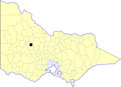
The Shire of Northern Grampians is a local government area in the Wimmera region of Victoria, Australia, located in the western part of the state. It covers an area of 5,918 square kilometres (2,285 sq mi) and at the 2016 Census had a population of approximately 11,500. It includes the towns of Stawell, St Arnaud, Great Western, Marnoo, Glenorchy, Stuart Mill, Navarre and the tourist town of Halls Gap. It was formed in 1995 from the amalgamation of the City of Stawell, Town of St Arnaud, Shire of Stawell, Shire of Kara Kara and parts of the Shire of Wimmera, Shire of Dunmunkle and Shire of Donald.
The Borung Highway is a 140–kilometre rural highway in western Victoria running in a west–east direction from Dimboola in the west to Charlton in the east. The highway serves little more than connectivity between local communities, and is busiest between the towns of Donald and Charlton.

The County of Grenville is one of the 37 counties of Victoria which are part of the cadastral divisions of Australia, used for land titles. It is located to the north-east of Lake Corangamite and includes Cressy. Ballarat is on its north-eastern edge. The boundary to the east is the Yarrowee River, and to the south part of the Barwon River. Colac is on its southern edge. The county was proclaimed in 1849.

The County of Bendigo is one of the 37 counties of Victoria which are part of the cadastral divisions of Australia, used for land titles. It includes the city of Bendigo. It is bounded by the Campaspe River in the east, and the Loddon River in the west. The county was proclaimed in 1869.

The Shire of Charlton was a local government area about 240 kilometres (149 mi) north-northwest of Melbourne, the state capital of Victoria, Australia. The shire covered an area of 1,175 square kilometres (453.7 sq mi), and existed from 1895 until 1995.

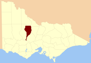
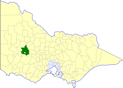
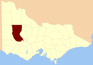
The Shire of Donald was a local government area about 140 kilometres (87 mi) west-northwest of Bendigo, in western Victoria, Australia. The shire covered an area of 1,448 square kilometres (559.1 sq mi), and existed from 1861 until 1995.

The Shire of Karkarooc was a local government area in northwestern Victoria, Australia. The shire covered an area of 3,719 square kilometres (1,435.9 sq mi), and existed from 1896 until 1995.

The Shire of Warracknabeal was a local government area about 200 kilometres (124 mi) west-northwest of Bendigo and 60 kilometres (37 mi) north of Horsham in western Victoria, Australia. The shire covered an area of 1,839 square kilometres (710.0 sq mi), and existed from 1891 until 1995.

The Shire of Wycheproof was a local government area about 130 kilometres (81 mi) northwest of Bendigo in northwestern Victoria, Australia. The shire covered an area of 4,110.3 square kilometres (1,587.0 sq mi), and existed from 1894 until 1995.
The Shire of Stawell was a local government area about 230 kilometres (143 mi) west-northwest of Melbourne, the state capital of Victoria, Australia. The shire covered an area of 2,606 square kilometres (1,006.2 sq mi), and existed from 1861 until 1994.
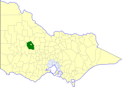
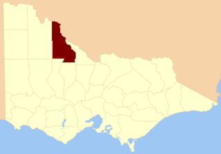
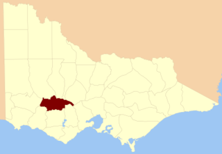
The Shire of Kara Kara was a local government area about 240 kilometres (149 mi) northwest of Melbourne, the state capital of Victoria, Australia. The shire covered an area of 2,292.79 square kilometres (885.3 sq mi), and existed from 1861 until 1994.
The Town of St Arnaud was a local government area about 240 kilometres (149 mi) northwest of Melbourne, the state capital of Victoria, Australia. The town covered an area of 25.92 square kilometres (10.0 sq mi) and existed from 1861 until 1994. Its area was surrounded by the Shire of Kara Kara.

The County of Lowan is one of the 37 counties of Victoria which are part of the cadastral divisions of Australia, used for land titles. The northern boundary of the county is at 36°S. Larger towns include Dimboola, Edenhope and Kaniva. The county was proclaimed in 1871 together with the other counties of the Wimmera Land District.
The County of Ripon is one of the 37 counties of Victoria which are part of the cadastral divisions of Australia, used for land titles. The county includes the plains of the Western District from Ballarat in the east to the Grampians in the west. Larger towns include Beaufort. The county was proclaimed in 1849.

The County of Dundas is one of the 37 counties of Victoria which are part of the cadastral divisions of Australia, used for land titles. The county is in the Western District of Victoria bounded by the Glenelg River in the west and north, by a line from Casterton to Penshurst in the south, and by the eastern edge of the Grampians in the east. Larger towns include Hamilton, Casterton and Coleraine. The county was proclaimed in 1849.
The electoral district of Borung was an electorate of the Victorian Legislative Assembly in the Australian colony of Victoria, which existed in two incarnations, from 1889 to 1927, and then from 1945 to 1955.
Kara Kara was an electoral district of the Legislative Assembly in the Australian state of Victoria from 1877 to 1927 and 1955 to 1976. It was based in north-western Victoria and included the subdivisions of Donald, Charlton, Minyip, Murtoa, St. Arnaud, Wedderburn, Inglewood, Dunnolly, Landsborough, Avoca, Maryborough and Carisbrook.