Shepparton is a city located on the floodplain of the Goulburn River in northern Victoria, Australia, approximately 181 kilometres (112 mi) north-northeast of Melbourne. At June 2016, the estimated urban population of Shepparton, including Mooroopna, was 50,198.
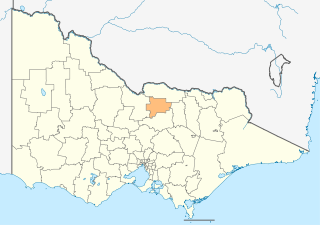
The City of Greater Shepparton is a local government area in the Hume region of Victoria, Australia, located in the north-east part of the state. It covers an area of 2,422 square kilometres (935 sq mi) and, at the 2016 Census, had a population of 63,867. It includes the city of Shepparton and the towns of Arcadia, Ardmona, Congupna, Dookie, Grahamvale, Kialla, Lemnos, Merrigum, Mooroopna, Murchison, Tallygaroopna, Tatura, Toolamba and Undera. It was formed in 1994 from the amalgamation of the City of Shepparton, Shire of Shepparton, and parts of the Shire of Rodney, Shire of Euroa, Shire of Goulburn, Shire of Tungamah, Shire of Violet Town and Shire of Waranga.

The Shire of Campaspe is a local government area in Victoria, Australia, located in the northern part of the state. It covers an area of 4,519 square kilometres (1,745 sq mi) and at the 2016 census had a population of approximately 37,000.

Kyabram is located in the centre of a rich irrigation district in the Goulburn River Valley, in the Australian state of Victoria, 200 kilometres (120 mi) north of Melbourne. Kyabram, the second-largest town in the Shire of Campaspe, is situated between the towns of Echuca and Shepparton and is close to the Murray River, Goulburn River, Campaspe River and Waranga Basin. As of the 2011 census the town had a population of 7,321 people and provides services to a district population of around 16,000.

The Goulburn Valley is a sub-region, part of the Hume region of the Australian state of Victoria. The sub-region consists of those areas in the catchment of the Goulburn River and other nearby streams, and is part of the Murray-Darling Basin. The Goulburn Valley is bordered on the south by the Great Dividing Range and to the north by the Murray River, the state border with New South Wales. The sub-region is one of Australia's most productive and intensively farmed areas and is predominantly irrigated.
The Kyabram District Football League (KDFL) is an Australian rules football league in Victoria. It is made up of 14 teams, following Yea's departure in 2007 to join the Yarra Valley Mountain Football League, and Longwood's admission in 2010 following the collapse of the Benalla District Football League. The KDFL is made up of smaller country town football clubs in the Goulburn Valley. The majority of these towns have a population base of around 500 people, each of these clubs fields three football sides in the Senior, Reserve and Under 18 divisions of the KDFL as well as five netball sides in A-Grade, B-Grade, C-Grade, Under 17 and Under 15 divisions of the KDNL.
Murchison-Toolamba Football Netball Club, nicknamed the Grasshoppers, is an Australian Rules Football and Netball club that plays its home games in the small north eastern Victoria town of Murchison. Its name also recognises the town of Toolamba.

The Goulburn Valley Football League (GVFL) is an Australian rules football competition based in the Goulburn Valley region of Victoria, Australia. Participating clubs also field netball teams that compete in a concurrent league.

Murchison East railway station is located on the Shepparton railway line in Victoria, Australia. It serves the town of Murchison, and opened on 13 January 1880.
The Tocumwal railway line is a 1,600 mm gauge railway line in Victoria, Australia. The line runs between the border town of Tocumwal in New South Wales to Southern Cross on the western edge of the Melbourne central business district. The line is utilised by various passenger and freight trains serving the northern suburbs of Melbourne and northern regions of Victoria.

The County of Bendigo is one of the 37 counties of Victoria which are part of the cadastral divisions of Australia, used for land titles. It includes the city of Bendigo. It is bounded by the Campaspe River in the east, and the Loddon River in the west. The county was proclaimed in 1869.

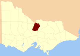
The Shire of Deakin was a local government area in the Goulburn Valley region, about 200 kilometres (124 mi) north of Melbourne, the state capital of Victoria, Australia. The shire covered an area of 961 square kilometres (371.0 sq mi), and existed from 1893 until 1994.

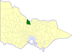
The Shire of Rodney was a local government area in the Goulburn Valley region, about 170 kilometres (106 mi) north of Melbourne, the state capital of Victoria, Australia, located between Kyabram and Shepparton. The shire covered an area of 1,009.92 square kilometres (389.9 sq mi), and existed from 1886 until 1994.

The Shire of Waranga was a local government area about 165 kilometres (103 mi) north of Melbourne, the state capital of Victoria, Australia. The shire covered an area of 1,644.19 square kilometres (634.8 sq mi), and existed from 1863 until 1994.

The Town of Kyabram was a local government area in the Goulburn Valley region, about 200 kilometres (124 mi) north of Melbourne, the state capital of Victoria, Australia, and 35 kilometres (22 mi) west of Shepparton. The town covered an area of 25.85 square kilometres (10.0 sq mi), and existed from 1954 until 1994.
The Shire of Rochester was a local government area of Victoria, Australia, about 190 kilometres (118 mi) north of Melbourne, the state capital, and immediately west and southwest of the town of Echuca. The shire covered an area of 1,934.25 square kilometres (746.8 sq mi), and existed from 1864 until 1994.

The City of Echuca was a local government area of Victoria, Australia, about 200 kilometres (124 mi) north of Melbourne, the state capital, in the regional centre of Echuca, on the Murray River. The city covered an area of 26.06 square kilometres (10.1 sq mi), and existed from 1865 until 1994.
Merrigum was a railway station at Merrigum, on the Toolamba–Echuca line, in Victoria, Australia. All that remains of the station is the mound on which the platform stood, and a section of track placed in what was the rail yard.
Kyabram railway station was opened on Friday, 19 August 1887. It is on the Toolamba–Echuca railway line, in Victoria, Australia.