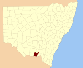
Hume County

Last updated

Map all coordinates using: OpenStreetMap  
Download coordinates as: KML
Hume
New South Wales
Hume NSW.PNG
Location in New South Wales
Lands administrative divisions around Hume:
Urana Urana Mitchell
Denison Hume Goulburn
Moira (Vic) Bogong (Vic) Benambra (Vic)
Map_of_Hume_County_(NSW)_Australia Map of Hume County (NSW) Australia.png
Map_of_Hume_County_(NSW)_Australia

Hume County is one of the 141 cadastral divisions of New South Wales. It contains the town of Culcairn.

Hume County was named in honour of the explorer Hamilton Hume (1797-1873). [1]

Parishes within this county

A full list of parishes found within this county; their current LGA and mapping coordinates to the approximate centre of each location is as follows:

ParishLGACoordinates
Billabong Forest Federation Council 35°44′54″S146°18′04″E / 35.74833°S 146.30111°E / -35.74833; 146.30111 (Billabong Forest)
Brocklesby Greater Hume Shire Council 35°47′54″S146°39′04″E / 35.79833°S 146.65111°E / -35.79833; 146.65111 (Brocklesby)
Buckargingah Greater Hume Shire Council 35°29′54″S147°09′04″E / 35.49833°S 147.15111°E / -35.49833; 147.15111 (Buckargingah)
Bulgandry Greater Hume Shire Council 35°35′12″S146°38′19″E / 35.58667°S 146.63861°E / -35.58667; 146.63861 (Bulgandry)
Bungowannah Greater Hume Shire Council 36°00′54″S146°48′04″E / 36.01500°S 146.80111°E / -36.01500; 146.80111 (Bungowannah)
Buraja Federation Council 35°52′54″S146°24′04″E / 35.88167°S 146.40111°E / -35.88167; 146.40111 (Buraja)
Burrangong Federation Council 35°27′54″S146°22′04″E / 35.46500°S 146.36778°E / -35.46500; 146.36778 (Burrangong)
Burrangong Federation Council 35°29′54″S146°22′04″E / 35.49833°S 146.36778°E / -35.49833; 146.36778 (Burrangong)
Burrumbuttock Greater Hume Shire Council 35°48′54″S146°47′04″E / 35.81500°S 146.78444°E / -35.81500; 146.78444 (Burrumbuttock)
Castlestead Greater Hume Shire Council 35°48′54″S146°54′04″E / 35.81500°S 146.90111°E / -35.81500; 146.90111 (Castlestead)
Collendina Federation Council 35°58′54″S146°14′04″E / 35.98167°S 146.23444°E / -35.98167; 146.23444 (Collendina)
Comer Greater Hume Shire Council 35°29′54″S147°01′04″E / 35.49833°S 147.01778°E / -35.49833; 147.01778 (Comer)
Comer Greater Hume Shire Council 35°32′54″S146°59′04″E / 35.54833°S 146.98444°E / -35.54833; 146.98444 (Comer)
Corowa Federation Council 35°57′44″S146°21′44″E / 35.96222°S 146.36222°E / -35.96222; 146.36222 (Corowa)
Creighton Greater Hume Shire Council 35°42′54″S147°01′04″E / 35.71500°S 147.01778°E / -35.71500; 147.01778 (Creighton)
Gibson Greater Hume Shire Council 35°39′54″S146°37′04″E / 35.66500°S 146.61778°E / -35.66500; 146.61778 (Gibson)
Goombargana Greater Hume Shire Council 35°42′54″S146°37′04″E / 35.71500°S 146.61778°E / -35.71500; 146.61778 (Goombargana)
Gordon Federation Council 35°38′54″S146°19′04″E / 35.64833°S 146.31778°E / -35.64833; 146.31778 (Gordon)
Granville Federation Council 35°39′54″S146°25′34″E / 35.66500°S 146.42611°E / -35.66500; 146.42611 (Granville)
Gray Federation Council 35°50′54″S146°16′04″E / 35.84833°S 146.26778°E / -35.84833; 146.26778 (Gray)
Henty Greater Hume Shire Council 35°29′54″S147°04′04″E / 35.49833°S 147.06778°E / -35.49833; 147.06778 (Henty)
Henty Greater Hume Shire Council 35°35′54″S147°00′04″E / 35.59833°S 147.00111°E / -35.59833; 147.00111 (Henty)
Hindmarsh Greater Hume Shire Council 35°42′54″S146°43′04″E / 35.71500°S 146.71778°E / -35.71500; 146.71778 (Hindmarsh)
Hovell Greater Hume Shire Council 35°52′54″S146°45′04″E / 35.88167°S 146.75111°E / -35.88167; 146.75111 (Hovell)
Howlong Federation Council 35°57′54″S146°39′04″E / 35.96500°S 146.65111°E / -35.96500; 146.65111 (Howlong)
Kentucky Federation Council 35°51′54″S146°32′04″E / 35.86500°S 146.53444°E / -35.86500; 146.53444 (Kentucky)
Lowes Federation Council 35°46′54″S146°25′04″E / 35.78167°S 146.41778°E / -35.78167; 146.41778 (Lowes)
Mahonga Forest Federation Council 35°31′54″S146°29′04″E / 35.53167°S 146.48444°E / -35.53167; 146.48444 (Mahonga Forest)
Mahonga Federation Council 35°31′54″S146°33′04″E / 35.53167°S 146.55111°E / -35.53167; 146.55111 (Mahonga)
Moorwatha Greater Hume Shire Council 35°55′00″S146°44′59″E / 35.91667°S 146.74972°E / -35.91667; 146.74972 (Moorwatha)
Morebringer Greater Hume Shire Council 35°53′54″S146°37′04″E / 35.89833°S 146.61778°E / -35.89833; 146.61778 (Morebringer)
Morven Greater Hume Shire Council 35°44′54″S147°04′04″E / 35.74833°S 147.06778°E / -35.74833; 147.06778 (Morven)
Osborne Federation Council 35°37′54″S146°31′04″E / 35.63167°S 146.51778°E / -35.63167; 146.51778 (Osborne)
Piney Range Greater Hume Shire Council 35°44′54″S146°49′04″E / 35.74833°S 146.81778°E / -35.74833; 146.81778 (Piney Range)
Quat Quatta Federation Council 35°56′54″S146°33′04″E / 35.94833°S 146.55111°E / -35.94833; 146.55111 (Quat Quatta)
Rand Federation Council 35°29′54″S146°27′04″E / 35.49833°S 146.45111°E / -35.49833; 146.45111 (Rand)
Richmond Federation Council 35°46′54″S146°32′04″E / 35.78167°S 146.53444°E / -35.78167; 146.53444 (Richmond)
Richmond Federation Council 35°44′54″S146°30′04″E / 35.74833°S 146.50111°E / -35.74833; 146.50111 (Richmond)
Round Hill Greater Hume Shire Council 35°37′54″S147°01′04″E / 35.63167°S 147.01778°E / -35.63167; 147.01778 (Round Hill)
Ryan Greater Hume Shire Council 35°35′54″S146°44′04″E / 35.59833°S 146.73444°E / -35.59833; 146.73444 (Ryan)
Sandy Ridges Federation Council 35°53′54″S146°16′04″E / 35.89833°S 146.26778°E / -35.89833; 146.26778 (Sandy Ridges)
Sherwyn Greater Hume Shire Council 35°38′54″S146°50′04″E / 35.64833°S 146.83444°E / -35.64833; 146.83444 (Sherwyn)
Stitt Greater Hume Shire Council 35°37′54″S146°56′04″E / 35.63167°S 146.93444°E / -35.63167; 146.93444 (Stitt)
Thugga Greater Hume Shire Council 35°05′54″S147°07′04″E / 35.09833°S 147.11778°E / -35.09833; 147.11778 (Thugga)
Walbundrie Greater Hume Shire Council 35°39′54″S146°44′04″E / 35.66500°S 146.73444°E / -35.66500; 146.73444 (Walbundrie)
Walla Walla Greater Hume Shire Council 35°43′54″S146°54′04″E / 35.73167°S 146.90111°E / -35.73167; 146.90111 (Walla Walla)
Wilson Federation Council 35°32′54″S146°19′04″E / 35.54833°S 146.31778°E / -35.54833; 146.31778 (Wilson)

Related Research Articles

<span class="mw-page-title-main">Hamilton Hume</span> Australian explorer (1797–1873)

Hamilton Hume was an early explorer of the present-day Australian states of New South Wales and Victoria. In 1824, along with William Hovell, Hume participated in an expedition that first took an overland route from Sydney to Port Phillip. Along with Sturt in 1828, he was part of an expedition of the first Europeans to find the Darling River.

<span class="mw-page-title-main">Hume Dam</span> Dam in Riverina, New South Wales

Hume Dam, formerly the Hume Weir, is a major dam across the Murray River downstream of its junction with the Mitta River in the Riverina region of New South Wales, Australia. The dam's purpose includes flood mitigation, hydro-power, irrigation, water supply and conservation. The impounded reservoir is called Lake Hume, formerly the Hume Reservoir. It is a gated concrete gravity dam with four earth embankments and twenty-nine vertical undershot gated concrete overflow spillways.

<span class="mw-page-title-main">Cumberland Highway</span>

Cumberland Highway is a 34-kilometre (21 mi) long urban highway located in Sydney, New South Wales, Australia. The highway links Pacific Highway and Pacific Motorway (M1) at Pearces Corner, Wahroonga in the northeast with Hume Highway at Liverpool in the southwest. This name covers a few consecutive roads and is widely known to most drivers, but the entire allocation is also known – and signposted – by the names of its constituent parts: Pennant Hills Road, James Ruse Drive, Briens Road, Old Windsor Road, Hart Drive, Freame Street, Emert Street, Jersey Road, Betts Road, Warren Road, Smithfield Road, Palmerston Road, (New) Cambridge Street, Joseph Street and Orange Grove Road. The entire length of Cumberland Highway is designated part of route A28.

<span class="mw-page-title-main">Breadalbane, New South Wales</span> Town in New South Wales, Australia

Breadalbane is a small village located in the Southern Tablelands of New South Wales, Australia in Upper Lachlan Shire. It is located on the Lachlan River headwaters and not far from Goulburn. At the 2021 census, Breadalbane had a population of 107.
<span class="mw-page-title-main">Coolac, New South Wales</span> Town in New South Wales, Australia

Coolac is a village in the Riverina region of New South Wales, Australia in Gundagai Council. At the 2016 census, Coolac had a population of 216.

Towrang is a village in the Southern Tablelands of New South Wales, Australia, in Goulburn Mulwaree Council. It is approximately 13 kilometres (8.1 mi) north of Goulburn on the Hume Highway 180 kilometres (110 mi) south from Sydney. At the 2016 census, Towrang had a population of 171.

<span class="mw-page-title-main">Yass River</span> River in New South Wales, Australia

The Yass River, a perennial river that is part of the Murrumbidgee catchment within the Murray–Darling basin, is located in the Southern Tablelands and South Western Slopes districts of New South Wales, Australia.

<span class="mw-page-title-main">Bowning</span> Town in New South Wales, Australia

Bowning is a small town in the Southern Tablelands, 14 kilometres (8.7 mi) west of Yass on the Hume Highway in Yass Valley Shire. Bowning is an aboriginal word meaning 'big hill'. At the 2016 census, Bowning and the surrounding area had a population of 573.

Bowna is a locality in the South East part of the Riverina, New South Wales, Australia.

The Parish of Mittagong is a parish of the County of Camden in the Southern Highlands region of New South Wales. It includes the town of Bowral and the southern parts of Mittagong.

<span class="mw-page-title-main">Colo Parish</span> Cadastral in New South Wales, Australia

The Parish of Colo is a parish of the County of Camden in the Southern Highlands region of New South Wales. It is centred on the town of Colo Vale, and includes Aylmerton, Willow Vale, Alpine and Yerrinbool. It also includes the northern parts of Mittagong that are north of the Old Hume Highway. The new Hume Highway runs through the parish from south-west to north-east.

<span class="mw-page-title-main">Goobarragandra River</span> River in New South Wales, Australia

Goobarragandra River, a perennial stream that is part of the Murrumbidgee catchment within the Murray–Darling basin, is located in the Snowy Mountains region of New South Wales, Australia. In the past, it was also known as Tumut Little River.

The Paddys River, a perennial river that is part of the Hawkesbury-Nepean catchment, is located in the Southern Highlands region of New South Wales, Australia.

The Tarcutta Creek, part of the Murray Darling basin, is mostly a perennial stream located in the Riverina region of New South Wales, Australia.

The Little River, a perennial river that is part of the Hawkesbury-Nepean catchment, is located in the Southern Highlands region of New South Wales, Australia.

The Adelong Creek, a perennial river that is part of the Murrumbidgee catchment within the Murray–Darling basin, is located in the South West Slopes, and Riverina regions of New South Wales, Australia.

The Jugiong Creek, a mostly–perennial river that is part of the Murrumbidgee catchment within the Murray–Darling basin, is located in the South West Slopes region of New South Wales, Australia.

Bowning Creek, a mostly–perennial river that is part of the Murrumbidgee catchment in the Murray–Darling basin, is in the South West Slopes and Riverina regions of New South Wales, Australia.

The Derringullen Creek, a mostly–perennial river that is part of the Murrumbidgee catchment within the Murray–Darling basin, is located in the South West Slopes region of New South Wales, Australia.

Illalong is a rural locality just off the Burley Griffin Way in south New South Wales.

References

  1. "Hume County". Geographical Names Register (GNR) of NSW. Geographical Names Board of New South Wales. OOjs UI icon edit-ltr-progressive.svg