Harden County

Last updated

Map all coordinates using: OpenStreetMap  
Download coordinates as: KML  ·  GPX
Harden
New South Wales
Harden NSW.PNG
Location in New South Wales
Lands administrative divisions around Harden:
Bland Monteagle King
Clarendon Harden King
Wynyard Buccleuch Murray

Harden County is one of the 141 cadastral divisions of New South Wales. It contains the town of Harden.

The origin of the name of Harden is unknown. [1]

Parishes within this county

A full list of parishes found within this county; their current local government area (LGA) and mapping coordinates to the approximate centre of each location is as follows:

ParishLGACoordinates
Beggan Beggan Hilltops Council 34°39′54″S148°21′04″E / 34.66500°S 148.35111°E / -34.66500; 148.35111 (Beggan Beggan)
Binalong Yass Valley Council 34°39′54″S148°38′04″E / 34.66500°S 148.63444°E / -34.66500; 148.63444 (Binalong)
Birrema Hilltops Council 34°50′54″S148°28′04″E / 34.84833°S 148.46778°E / -34.84833; 148.46778 (Birrema)
Bobbara Hilltops Council 34°34′54″S148°37′04″E / 34.58167°S 148.61778°E / -34.58167; 148.61778 (Bobbara)
Bongongolong Cootamundra-Gundagai Regional Council 34°55′54″S148°06′04″E / 34.93167°S 148.10111°E / -34.93167; 148.10111 (Bongongalong)
Bookham Yass Valley Council 34°47′54″S148°38′04″E / 34.79833°S 148.63444°E / -34.79833; 148.63444 (Bookham)
Bowning Yass Valley Council 34°43′54″S148°48′04″E / 34.73167°S 148.80111°E / -34.73167; 148.80111 (Bowning)
Burra Cootamundra-Gundagai Regional Council 34°53′54″S148°00′04″E / 34.89833°S 148.00111°E / -34.89833; 148.00111 (Burra)
Childowla Yass Valley Council 34°58′54″S148°36′04″E / 34.98167°S 148.60111°E / -34.98167; 148.60111 (Childowla)
Coolac Cootamundra-Gundagai Regional Council 34°58′54″S148°11′04″E / 34.98167°S 148.18444°E / -34.98167; 148.18444 (Coolac)
Cooney Cootamundra-Gundagai Regional Council 34°44′54″S148°12′04″E / 34.74833°S 148.20111°E / -34.74833; 148.20111 (Cooney)
Cootamundra Cootamundra-Gundagai Regional Council 34°37′54″S147°00′04″E / 34.63167°S 147.00111°E / -34.63167; 147.00111 (Cootamundra)
Coppabella Hilltops Council 34°44′54″S148°30′04″E / 34.74833°S 148.50111°E / -34.74833; 148.50111 (Coppabella)
Cowcumbala Cootamundra-Gundagai Regional Council 34°43′54″S148°04′04″E / 34.73167°S 148.06778°E / -34.73167; 148.06778 (Cowcumbala)
Cullinga Cootamundra-Gundagai Regional Council 34°36′54″S147°10′04″E / 34.61500°S 147.16778°E / -34.61500; 147.16778 (Cullinga)
Cumbamurra Hilltops Council 34°37′54″S148°26′04″E / 34.63167°S 148.43444°E / -34.63167; 148.43444 (Cumbamurra)
Cunjegong Cootamundra-Gundagai Regional Council 34°42′54″S147°57′04″E / 34.71500°S 147.95111°E / -34.71500; 147.95111 (Cunjegong)
Cunningar Hilltops Council 34°31′54″S148°26′04″E / 34.53167°S 148.43444°E / -34.53167; 148.43444 (Cunningar)
Cunningham Hilltops Council 34°46′54″S148°21′04″E / 34.78167°S 148.35111°E / -34.78167; 148.35111 (Cunningham)
Currawong Hilltops Council 34°27′54″S148°22′04″E / 34.46500°S 148.36778°E / -34.46500; 148.36778 (Currawong)
Demondrille Hilltops Council 34°30′54″S148°14′04″E / 34.51500°S 148.23444°E / -34.51500; 148.23444 (Demondrille)
Douglas Hilltops Council 34°27′54″S148°30′04″E / 34.46500°S 148.50111°E / -34.46500; 148.50111 (Douglas)
Eubindal Yass Valley Council 34°36′54″S148°42′04″E / 34.61500°S 148.70111°E / -34.61500; 148.70111 (Eubindal)
Galong Harden Shire 34°32′54″S148°31′04″E / 34.54833°S 148.51778°E / -34.54833; 148.51778 (Galong)
Gobarralong Cootamundra-Gundagai Regional Council 34°54′54″S148°16′04″E / 34.91500°S 148.26778°E / -34.91500; 148.26778 (Gobarralong)
Gooramma Hilltops Council 34°30′54″S148°34′04″E / 34.51500°S 148.56778°E / -34.51500; 148.56778 (Gooramma)
Harden Hilltops Council 34°37′54″S148°33′04″E / 34.63167°S 148.55111°E / -34.63167; 148.55111 (Harden)
Illalong Yass Valley Council 34°41′54″S148°45′04″E / 34.69833°S 148.75111°E / -34.69833; 148.75111 (Illalong)
Jindalee Cootamundra-Gundagai Regional Council 34°33′54″S147°03′04″E / 34.56500°S 147.05111°E / -34.56500; 147.05111 (Jindalee)
Jugiong Hilltops Council 34°47′54″S148°21′04″E / 34.79833°S 148.35111°E / -34.79833; 148.35111 (Jugiong)
Mooney Mooney Cootamundra-Gundagai Regional Council 34°50′54″S148°12′04″E / 34.84833°S 148.20111°E / -34.84833; 148.20111 (Mooney Mooney)
Moppity Young Shire 34°22′54″S148°23′04″E / 34.38167°S 148.38444°E / -34.38167; 148.38444 (Moppity)
Murrimboola Hilltops Council 34°31′54″S148°22′04″E / 34.53167°S 148.36778°E / -34.53167; 148.36778 (Murrimboola)
Muttama Cootamundra-Gundagai Regional Council 34°45′54″S148°00′04″E / 34.76500°S 148.00111°E / -34.76500; 148.00111 (Muttama)
Mylora Yass Valley Council 34°43′54″S148°38′04″E / 34.73167°S 148.63444°E / -34.73167; 148.63444 (Mylora)
Nubba Hilltops Council 34°28′54″S148°10′04″E / 34.48167°S 148.16778°E / -34.48167; 148.16778 (Nubba)
Nurung Hilltops Council 34°29′54″S148°34′04″E / 34.49833°S 148.56778°E / -34.49833; 148.56778 (Nurung)
Talmo Yass Valley Council 34°52′54″S148°36′04″E / 34.88167°S 148.60111°E / -34.88167; 148.60111 (Talmo)
Wallendoon Cootamundra-Gundagai Regional Council 34°32′54″S147°10′04″E / 34.54833°S 147.16778°E / -34.54833; 147.16778 (Wallendoon)
Wambat Hilltops Council 34°28′54″S148°15′04″E / 34.48167°S 148.25111°E / -34.48167; 148.25111 (Wambat)
Wilkie Hilltops Council 34°24′54″S148°16′04″E / 34.41500°S 148.26778°E / -34.41500; 148.26778 (Wilkie)
Woolgarlo Yass Valley Council 34°52′54″S148°43′04″E / 34.88167°S 148.71778°E / -34.88167; 148.71778 (Woolgarlo)

Related Research Articles

Harden, New South Wales Town in New South Wales, Australia

Harden–Murrumburrah is a township and community in the Hilltops Region and is located in the South West Slopes of New South Wales in Australia and is adjacent to both the Canberra region of the Australian Capital Territory and the Riverina Region in the southwest area of NSW. The town is a twin town between Harden and Murrumburrah.

The Geographical Names Board of New South Wales, a statutory authority of the Department of Customer Service in the Government of New South Wales, is the official body for naming and recording details of places and geographical names in the state of New South Wales, Australia.

Boorowa Shire Local government area in New South Wales, Australia

Boorowa Council was a local government area in the South West Slopes region of New South Wales, Australia. The shire was located adjacent to the Lachlan Valley Way and included Boorowa and the small towns of Rye Park, Rugby, Frogmore and Reids Flat. Burrowa Shire was formed on 1 September 1944 through the amalgamation of Murrungal Shire and the Municipality of Burrowa.

Harden Shire Local government area in New South Wales, Australia

Harden Shire was a local government area in the South West Slopes region of New South Wales, Australia. The Shire included the twin towns of Harden and Murrumburrah and the small towns of Galong, Jugiong, Wombat and Kingsvale.

Murrumburrah Town in New South Wales, Australia

Murrumburrah is a township in New South Wales, Australia, part of a twin town with Harden. The town is in Hilltops Council local government area in the South West Slopes area of NSW. It is on the Burley Griffin Way, the major link from the Riverina to the Hume Highway near Yass, and ultimately Sydney, Canberra and the coast. At the 2011 census, Murrumburrah had a population of 479.

Darbalara, New South Wales Town in New South Wales, Australia

Darbalara is a rural community on the east bank of the junction of the Murrumbidgee River and Tumut River in the Riverina. It is situated by road, about 25 kilometres north east of Gundagai and 25 kilometres south of Coolac.

Nubba is a locality and former railway station on the Main South railway line in New South Wales, Australia, located midway between Wallendbeen and Harden. The station was open between 1882 and 1975 and has now been demolished. At the 2006 census, Nubba had a population of 281 people.

Napier is a locality in the Riverina district of New South Wales, Australia and also a civil parish of Buccleuch County, New South Wales.

<i>Lomatia myricoides</i> Species of shrub in the family Proteaceae native to New South Wales and Victoria in southeastern Australia

Lomatia myricoides, commonly known as the river lomatia, is a shrub native to New South Wales and Victoria in southeastern Australia.

<i>Murrumburrah Signal and County of Harden Advocate</i>

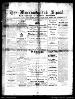
The Murrumburrah Signal and County of Harden Advocate, also known as the Murrumburrah Signal, andThe Signal, Murrumburrah-Harden, was an English language newspaper published from 1881 to 1947 in Murrumburrah, New South Wales, Australia.

Illalong is a rural locality just off the Burley Griffin Way in south New South Wales.

Peppercorn, New South Wales is a civil parish of Buccleuch County in Snowy Valleys Council, New South Wales.

Birrema, New South Wales

Birrema, New South Wales is a civil parish of Harden County, New South Wales.

Currawong, New South Wales, is rural locality of Hilltops Council and is a civil parish of Harden County, New South Wales.

Coppabella, New South Wales

Coppabella, New South Wales is a rural locality of Hilltops Council and a civil parish of Harden County, New South Wales.

Bobbara, New South Wales

Bobbara, New South Wales is a rural locality just off the Burley Griffin Way in south New South Wales.

Cowcumbala, New South Wales

Cowcumbala, New South Wales is a rural locality and civil parish of Harden County, New South Wales.

Cumbamurra, New South Wales

Cumbamurra, New South Wales is a civil parish of Harden County, New South Wales.

Murrimboola, New South Wales New South Wales, Australia

Murrimboola, New South Wales is a rural locality and civil parish of Harden County, New South Wales. The parish is at Harden, New South Wales, on Currawong Creek.

Talluba (Baradine County parish) New South Wales, Australia

Talluba Parish(Baradine County) is a civil parish of Baradine County, New South Wales.

References

  1. "Harden County". Geographical Names Register (GNR) of NSW. Geographical Names Board of New South Wales. OOjs UI icon edit-ltr-progressive.svg