Bligh County

Last updated

Map all coordinates using: OpenStreetMap  
Download coordinates as: KML  ·  GPX
Bligh
New South Wales
Bligh NSW.PNG
Location in New South Wales
Lands administrative divisions around Bligh:
Napier Pottinger Buckland
Lincoln Bligh Brisbane
Gordon Wellington Phillip

Bligh County was one of the original Nineteen Counties in New South Wales and is now one of the 141 Cadastral divisions of New South Wales. The Cudgegong River and the Goulburn River are its southern boundaries; the Krui River is the eastern boundary, and the Burragundy River the northern boundary. It includes the villages of Cassilis and Dunedoo.

Nineteen Counties area of New South Wales colony to which European settlement was legally restricted from 1826 until 1861

The Nineteen Counties were the limits of location in the colony of New South Wales, Australia. Settlers were permitted to take up land only within the counties due to the dangers in the wilderness.

New South Wales State of Australia

New South Wales is a state on the east coast of Australia. It borders Queensland to the north, Victoria to the south, and South Australia to the west. Its coast borders the Tasman Sea to the east. The Australian Capital Territory is an enclave within the state. New South Wales' state capital is Sydney, which is also Australia's most populous city. In December 2018, the population of New South Wales was over 8 million, making it Australia's most populous state. Just under two-thirds of the state's population, 5.1 million, live in the Greater Sydney area. Inhabitants of New South Wales are referred to as New South Welshmen.

Cudgegong River river in Australia

Cudgegong River, a perennial stream that is part of the Macquarie catchment within the Murray-Darling basin, is located in the central western and Orana districts of New South Wales, Australia.

The county was named after William Bligh, Admiral and Governor of New South Wales (1805-1808). [1] The electoral district of Phillip, Brisbane and Bligh was the first electoral district for the area, between 1856 and 1859.

William Bligh officer of the British Royal Navy and a colonial administrator

Vice-Admiral William Bligh was an officer of the Royal Navy and a colonial administrator. The Mutiny on the Bounty occurred during his command of HMS Bounty in 1789; after being set adrift in Bounty's launch by the mutineers, Bligh and his loyal men reached Timor, a journey of 3,618 nautical miles.

Phillip, Brisbane and Bligh was an electoral district of the Legislative Assembly in the Australian state of New South Wales from 1856 to 1859. It included Phillip, Brisbane and Bligh counties, including Scone, Murrurundi, Dunedoo and Mudgee. It was replaced by Upper Hunter and Mudgee.

Parishes within this county

A full list of parishes found within this county; their current LGA and mapping coordinates to the approximate centre of each location is as follows:

Local government in Australia third tier of government in Australia

Local government in Australia is the third tier of government in Australia administered by the states and territories, which in turn are beneath the federal tier. Local government is not mentioned in the Constitution of Australia and two referenda in the 1970s and 1980s to alter the Constitution relating to local government were unsuccessful. Every state government recognises local government in their respective constitutions. Unlike Canada or the United States, there is only one level of local government in each state, with no distinction such as cities and counties.

ParishLGACoordinates
Bellaleppa Upper Hunter Shire 32°01′54″S150°07′04″E / 32.03167°S 150.11778°E / -32.03167; 150.11778 (Bellaleppa)
Berenderry Upper Hunter Shire 32°00′54″S150°10′04″E / 32.01500°S 150.16778°E / -32.01500; 150.16778 (Berenderry)
Bligh Mid-Western Regional Council 32°09′54″S149°42′04″E / 32.16500°S 149.70111°E / -32.16500; 149.70111 (Bligh)
Bobadeen Mid-Western Regional Council 32°10′54″S149°48′04″E / 32.18167°S 149.80111°E / -32.18167; 149.80111 (Bobadeen)
Booyamurna Warrumbungle Shire 31°47′54″S149°50′04″E / 31.79833°S 149.83444°E / -31.79833; 149.83444 (Booyamurna)
Borambil Upper Hunter Shire 32°02′54″S150°02′04″E / 32.04833°S 150.03444°E / -32.04833; 150.03444 (Borambil)
Bowman Warrumbungle Shire 32°03′54″S149°37′04″E / 32.06500°S 149.61778°E / -32.06500; 149.61778 (Bowman)
Bulga Upper Hunter Shire 31°52′54″S149°59′04″E / 31.88167°S 149.98444°E / -31.88167; 149.98444 (Bulga)
Bungaba Mid-Western Regional Council 32°09′54″S149°38′04″E / 32.16500°S 149.63444°E / -32.16500; 149.63444 (Bungaba)
Collaroy Upper Hunter Shire 32°02′54″S150°01′04″E / 32.04833°S 150.01778°E / -32.04833; 150.01778 (Collaroy)
Collieblue Warrumbungle Shire 31°51′54″S149°46′04″E / 31.86500°S 149.76778°E / -31.86500; 149.76778 (Collieblue)
Collier Warrumbungle Shire 31°55′54″S149°45′04″E / 31.93167°S 149.75111°E / -31.93167; 149.75111 (Collier)
Cope Mid-Western Regional Council 32°16′54″S149°39′04″E / 32.28167°S 149.65111°E / -32.28167; 149.65111 (Cope)
Cunna Upper Hunter Shire 31°47′49″S150°05′47″E / 31.79694°S 150.09639°E / -31.79694; 150.09639 (Cunna)
Curryall Upper Hunter Shire 32°04′54″S149°50′04″E / 32.08167°S 149.83444°E / -32.08167; 149.83444 (Curryall)
Doulagunmala Upper Hunter Shire 31°56′54″S150°00′04″E / 31.94833°S 150.00111°E / -31.94833; 150.00111 (Doulagunmala)
Durridgere Mid-Western Regional Council 32°10′54″S149°53′04″E / 32.18167°S 149.88444°E / -32.18167; 149.88444 (Durridgere)
Goodiman Mid-Western Regional Council 32°12′54″S149°23′04″E / 32.21500°S 149.38444°E / -32.21500; 149.38444 (Goodiman)
Goolma Mid-Western Regional Council 32°18′54″S149°16′04″E / 32.31500°S 149.26778°E / -32.31500; 149.26778 (Goolma)
Guroba Dubbo Regional Council 32°29′24″S149°14′04″E / 32.49000°S 149.23444°E / -32.49000; 149.23444 (Guroba)
Lorimer Upper Hunter Shire 31°54′54″S150°13′04″E / 31.91500°S 150.21778°E / -31.91500; 150.21778 (Lorimer)
Merotherie Mid-Western Regional Council 32°08′54″S149°29′04″E / 32.14833°S 149.48444°E / -32.14833; 149.48444 (Merotherie)
Moan Upper Hunter Shire 31°51′10″S150°09′48″E / 31.85278°S 150.16333°E / -31.85278; 150.16333 (Moan)
Munmurra Mid-Western Regional Council 32°10′54″S150°01′04″E / 32.18167°S 150.01778°E / -32.18167; 150.01778 (Munmurra)
Nagora Upper Hunter Shire 31°53′54″S150°05′04″E / 31.89833°S 150.08444°E / -31.89833; 150.08444 (Nagora)
Nandoura Warrumbungle Shire 32°02′54″S149°48′04″E / 32.04833°S 149.80111°E / -32.04833; 149.80111 (Nandoura)
Nanima Dubbo Regional Council 32°29′54″S148°59′04″E / 32.49833°S 148.98444°E / -32.49833; 148.98444 (Nanima)
Narragamba Mid-Western Regional Council 32°10′54″S149°35′04″E / 32.18167°S 149.58444°E / -32.18167; 149.58444 (Narragamba)
Puggoon Mid-Western Regional Council 32°17′54″S149°27′04″E / 32.29833°S 149.45111°E / -32.29833; 149.45111 (Puggoon)
Rotherwood Warrumbungle Shire 31°49′54″S150°01′04″E / 31.83167°S 150.01778°E / -31.83167; 150.01778 (Rotherwood)
Rotherwood Warrumbungle Shire 31°52′24″S149°53′04″E / 31.87333°S 149.88444°E / -31.87333; 149.88444 (Rotherwood)
Rouse Mid-Western Regional Council 32°08′54″S149°26′04″E / 32.14833°S 149.43444°E / -32.14833; 149.43444 (Rouse)
Stubbo Mid-Western Regional Council 32°17′54″S149°34′04″E / 32.29833°S 149.56778°E / -32.29833; 149.56778 (Stubbo)
Talbragar Warrumbungle Shire 32°01′54″S149°33′04″E / 32.03167°S 149.55111°E / -32.03167; 149.55111 (Talbragar)
Tallawang Mid-Western Regional Council 32°12′54″S149°28′04″E / 32.21500°S 149.46778°E / -32.21500; 149.46778 (Tallawang)
Terraban Warrumbungle Shire 31°59′54″S149°39′04″E / 31.99833°S 149.65111°E / -31.99833; 149.65111 (Terraban)
Tomimbil Upper Hunter Shire 32°06′54″S150°00′04″E / 32.11500°S 150.00111°E / -32.11500; 150.00111 (Tomimbil)
Turee Warrumbungle Shire 31°58′54″S149°50′04″E / 31.98167°S 149.83444°E / -31.98167; 149.83444 (Turee)
Turill Upper Hunter Shire 32°01′54″S149°56′04″E / 32.03167°S 149.93444°E / -32.03167; 149.93444 (Turill)
Uarbry Warrumbungle Shire 32°02′54″S149°45′04″E / 32.04833°S 149.75111°E / -32.04833; 149.75111 (Uarbry)
Ulan Mid-Western Regional Council 32°14′54″S149°44′04″E / 32.24833°S 149.73444°E / -32.24833; 149.73444 (Ulan)
Wargundy Warrumbungle Shire 32°02′54″S149°27′04″E / 32.04833°S 149.45111°E / -32.04833; 149.45111 (Wargundy)
Warung Warrumbungle Shire 31°45′54″S150°03′04″E / 31.76500°S 150.05111°E / -31.76500; 150.05111 (Warung)
Wondaby Dubbo Regional Council 32°26′54″S149°12′04″E / 32.44833°S 149.20111°E / -32.44833; 149.20111 (Wondaby)
Worobil Mid-Western Regional Council 32°22′54″S149°13′04″E / 32.38167°S 149.21778°E / -32.38167; 149.21778 (Worobil)
Wuuluman Dubbo Regional Council 32°29′24″S149°10′04″E / 32.49000°S 149.16778°E / -32.49000; 149.16778 (Wuuluman)
Yarragal Dubbo Regional Council 32°35′54″S149°06′04″E / 32.59833°S 149.10111°E / -32.59833; 149.10111 (Yarragal)
Yarrobil Mid-Western Regional Council 32°19′54″S149°21′04″E / 32.33167°S 149.35111°E / -32.33167; 149.35111 (Yarrobil)

Related Research Articles

Electoral district of Hawkesbury state electoral district of New South Wales, Australia

Hawkesbury is an electoral district of the Legislative Assembly in the Australian state of New South Wales. It is represented by Robyn Preston of the Liberal Party.

Electoral district of Bathurst (County) electoral district of New South Wales (1856–1859)

Bathurst (County) was an electoral district of the Legislative Assembly in the Australian state of New South Wales, named after Bathurst County and including the rural part of the county. The electorate did not include the town of Bathurst which was included in Western Boroughs, until Bathurst was created in 1859. Bathurst (County) was replaced by Carcoar, East Macquarie and West Macquarie in 1859.

Lands administrative divisions of New South Wales Wikimedia list article

The lands administrative divisions of New South Wales refers to the 141 counties within the Colony of New South Wales, that later became the Australian state of New South Wales.

Camden County, New South Wales Cadastral in New South Wales, Australia

Camden County was one of the original Nineteen Counties in New South Wales and is now one of the 141 Cadastral divisions of New South Wales. It included the coastal area near Wollongong south to the Shoalhaven River, and also inland encompassing Berrima and Picton. Its western boundary was the Wollondilly River. The first settlement in the area was Camden Park, established by John Macarthur in 1806, just across the Nepean River from Cumberland County. It was the first land across the Nepean to be settled. Camden is a present-day suburb of Sydney in the same area, although parts of it are in Cumberland.

St Vincent County Cadastral in Australian Capital Territory

St Vincent County was one of the original Nineteen Counties in New South Wales and is now one of the 141 Cadastral divisions of New South Wales. It included the south coast area encompassing Batemans Bay, Ulladulla, Jervis Bay and inland to Braidwood. The Shoalhaven River is the boundary to the north and west, and the Deua River the boundary to the south.

Cook County, New South Wales Cadastral in New South Wales, Australia

Cook County was one of the original Nineteen Counties in New South Wales and is now one of the 141 Cadastral divisions of New South Wales. It includes the area to the west of Sydney in the Blue Mountains, between the Colo River in the north, and the Coxs River in the south and west, encompassing Lithgow, Mount Victoria, Katoomba, Wentworth Falls, Lawson and most of the other towns in the Blue Mountains. The Nepean River is the border to the east. Before 1834, the area was part of the Westmoreland, Northumberland and Roxburgh counties.

Westmoreland County, New South Wales Cadastral in New South Wales, Australia

Westmoreland County was one of the original Nineteen Counties in New South Wales and is now one of the 141 Cadastral divisions of New South Wales. It is to the west of Sydney in the Blue Mountains. Coxs River is the border to the north, and the Wollondilly River to the east. Campbells River is the border in the north-east, where the county extends to near Bathurst, with the Fish River part of the border. It includes the town of Oberon, and the Kanangra-Boyd National Park.

Georgiana County Cadastral in New South Wales, Australia

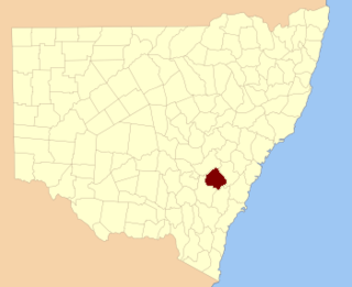
Georgiana County was one of the original Nineteen Counties in New South Wales and is now one of the 141 Cadastral divisions of New South Wales. It lies in the area about halfway between Bathurst and Goulburn. The Lachlan River is the western boundary, with the Crookwell River the southern boundary. It includes Bigga, and the area surrounding the Abercrombie River. It was part of the Electoral district of King and Georgiana from 1856 to 1859.

Bathurst County Cadastral in New South Wales, Australia

Bathurst County was one of the original Nineteen Counties in New South Wales and is now one of the 141 Cadastral divisions of New South Wales. It includes the area to the south-west of Bathurst to Cowra and Orange. The Lachlan River is the boundary to the south-west, the Belubula River forms part of the northern boundary, with the Fish River on the northeastern boundary. Blayney is located roughly in the middle.

Brisbane County Cadastral in New South Wales, Australia

Brisbane County was one of the original Nineteen Counties in New South Wales and is now one of the 141 Cadastral divisions of New South Wales. It includes Scone, Merriwa and Murrurundi. The Goulburn River is the boundary to the south and the Hunter River the boundary to the south-east. The Liverpool Range area is the boundary to the north, and the Krui River the boundary to the west.

Phillip County Cadastral in New South Wales, Australia

Phillip County was one of the original Nineteen Counties in New South Wales and is now one of the 141 Cadastral divisions of New South Wales. It includes the area to the east of Mudgee and Gulgong. The Cudgegong River is the border to the south-west, and the Goulburn River the border to the north.

East Sydney was an electoral district for the Legislative Assembly in the Australian colony of New South Wales created in 1859 from part of the electoral district of Sydney, covering the eastern part of the current Sydney central business district, Woolloomooloo, Potts Point, Elizabeth Bay and Darlinghurst, bordered by George Street to the east, Boundary Street to the west, and, from the creation of South Sydney in 1880, Liverpool Street and Oxford Street, to the south. It elected four members simultaneously, with voters casting four votes and the first four candidates being elected. For the 1894 election, it was replaced by the single-member electorates of Sydney-King, Sydney-Fitzroy and Sydney-Bligh.

Wellington and Bligh was an electoral district of the Legislative Assembly in the Australian state of New South Wales, named after Wellington County and Bligh County, and including Mudgee. There were also separate electoral districts of Wellington (County), covering part of Wellington County, and Phillip, Brisbane and Bligh, including part of Bligh County. In 1859, it was largely replaced by Mudgee.

Wellington (County) was an electoral district of the Legislative Assembly in the Australian state of New South Wales, created in 1856 and named after Wellington County and including Wellington. There was also a separate Wellington and Bligh, covering part of Wellington County. In 1859, it was largely replaced by Wellington.

Sydney-Bligh was an electoral district of the Legislative Assembly in the Australian state of New South Wales, in central Sydney, created in 1894, with the abolition of the multi-member district of East Sydney and named after naval officer and colonial administrator William Bligh. It was in the Darlinghurst area, bounded by Riley Street, William Street, King's Cross Road, Bayswater Road, Neild Avenue, Boundary Street and Oxford Street. It was abolished in 1904 and partly replaced by the electoral district of Darlinghurst.

This is a list of electoral results for the electoral district of Bligh in New South Wales state elections from its creation in 1962 until its abolition in 2007.

The Electoral district of Counties of Hunter, Brisbane and Bligh and from 1851, Phillip, Brisbane and Bligh, was an electorate of the partially elected New South Wales Legislative Council, created for the first elections for the Council in 1843. The electoral district included the north western counties of Hunter, Brisbane, Bligh. Polling took place in the towns of Jerrys Plains, nearby Merton, Muswellbrook, Scone, as far north as Murrurundi, Watson's on the Macdonald River, Cassilis and as far west as Montefiores. With the expansion of the Council in 1851 Phillip, the other north west county, was added to the district, replacing Hunter which was combined with the lower Hunter county of Northumberland as Counties of Northumberland and Hunter.

The Electoral district of Pastoral Districts of Lachlan and Lower Darling was an electorate of the New South Wales Legislative Council at a time when some of its members were elected and the balance were appointed by the Governor. It was a new electorate created in 1851 by the expansion of the Legislative Council to 54, 18 to be appointed and 36 elected. The district covered the south west of New South Wales was named after the Lachlan and Darling Rivers. On its eastern side were the districts of County of Bathurst and Counties of King and Georgiana, to the north was the Pastoral Districts of Wellington and Bligh and to the south was the Counties of Murray and St Vincent. Polling was to occur in the towns of Binalong, Wagga Wagga, Balranald, Canowindra, Gundagai and Yass.

The Electoral district of Pastoral Districts of Wellington and Bligh was an electorate of the New South Wales Legislative Council at a time when some of its members were elected and the balance were appointed by the Governor. It was a new electorate created in 1851 by the expansion of the Legislative Council to 54, 18 to be appointed and 36 elected. The district was located in the central west region of the state and covered the pastoral areas to the west of the Counties of Roxburgh and Wellington and Counties of Phillip, Brisbane and Bligh. To the north was the Pastoral Districts of Liverpool Plains and Gwydir and to the south the Pastoral Districts of Lachlan and Lower Darling. If polling had been required, it would have taken place in the towns of Molong, Wellington, Dubbo, Canowindra, Coola and Mudgee.

References

  1. "Bligh County". Geographical Names Register (GNR) of NSW. Geographical Names Board of New South Wales. OOjs UI icon edit-ltr-progressive.svg