Wellington County, New South Wales

Last updated

Map all coordinates using: OpenStreetMap  
Download coordinates as: KML  ·  GPX
Wellington
New South Wales
Wellington NSW.png
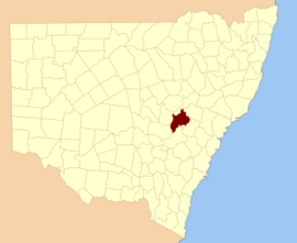
Location in New South Wales
Lands administrative divisions around Wellington:
Gordon Bligh Phillip
Ashburnham Wellington Roxburgh
Ashburnham Bathurst Roxburgh

Wellington County is a county in New South Wales, Australia, which was one of the original Nineteen Counties. The town of Wellington is near the north-eastern edge. The Bell River is the boundary to the west, and the Cudgegong River to the north. It includes land on both sides of the Macquarie River.

New South Wales State of Australia

New South Wales is a state on the east coast of Australia. It borders Queensland to the north, Victoria to the south, and South Australia to the west. Its coast borders the Tasman Sea to the east. The Australian Capital Territory is an enclave within the state. New South Wales' state capital is Sydney, which is also Australia's most populous city. In December 2018, the population of New South Wales was over 8 million, making it Australia's most populous state. Just under two-thirds of the state's population, 5.1 million, live in the Greater Sydney area. Inhabitants of New South Wales are referred to as New South Welshmen.

Nineteen Counties area of New South Wales colony to which European settlement was legally restricted from 1826 until 1861

The Nineteen Counties were the limits of location in the colony of New South Wales, Australia. Settlers were permitted to take up land only within the counties due to the dangers in the wilderness.

Wellington, New South Wales Town in New South Wales, Australia

Wellington is a town in inland New South Wales, Australia, located at the junction of the Macquarie and Bell Rivers. It is within the local government area of Dubbo Regional Council. The town is 362 kilometres (225 mi) from Sydney on the Great Western Highway and Mitchell Highway.

It contains the town of Mudgee, where the first house was stated to have been built in 1837 by John Blackman.

Mudgee Town in New South Wales, Australia

Mudgee is a town in the Central West of New South Wales, Australia. It is in the broad fertile Cudgegong River valley 261 km (162 mi) north-west of Sydney. Mudgee is at the centre of the Mid-Western Regional Council local government area. At the 2016 census, Mudgee had a population of 10,923 people.

There is a modern-day local government area called just "Wellington Council".

Wellington Council Local government area in New South Wales, Australia

Wellington Council was a local government area in the Orana region of New South Wales, Australia. The former area is located adjacent to the Macquarie River and the Mitchell Highway.

Wellington County was named in honour of Arthur Wellesley, Duke of Wellington (1769-1852). [1]

Arthur Wellesley, 1st Duke of Wellington 18th and 19th-century British soldier and statesman

Arthur Wellesley, 1st Duke of Wellington, was an Anglo-Irish soldier and Tory statesman who was one of the leading military and political figures of 19th-century Britain, serving twice as Prime Minister. He won a notable victory against Napoleon at the Battle of Waterloo in 1815.

Parishes within this county

A full list of parishes found within this county; their current LGA and mapping coordinates to the approximate centre of each location is as follows:

Local government in Australia third tier of government in Australia

Local government in Australia is the third tier of government in Australia administered by the states and territories, which in turn are beneath the federal tier. Local government is not mentioned in the Constitution of Australia and two referenda in the 1970s and 1980s to alter the Constitution relating to local government were unsuccessful. Every state government recognises local government in their respective constitutions. Unlike Canada or the United States, there is only one level of local government in each state, with no distinction such as cities and counties.

ParishLGACoordinates
Avisford Mid-Western Regional Council 32°44′54″S149°30′04″E / 32.74833°S 149.50111°E / -32.74833; 149.50111 (Avisford)
Biraganbil Mid-Western Regional Council 32°24′54″S149°25′04″E / 32.41500°S 149.41778°E / -32.41500; 149.41778 (Biraganbil)
Boduldura Dubbo Regional Council 32°52′54″S149°06′04″E / 32.88167°S 149.10111°E / -32.88167; 149.10111 (Boduldura)
Boiga Mid-Western Regional Council 32°53′54″S149°30′04″E / 32.89833°S 149.50111°E / -32.89833; 149.50111 (Boiga)
Boomey Cabonne Shire 32°57′54″S148°57′04″E / 32.96500°S 148.95111°E / -32.96500; 148.95111 (Boomey)
Boomey Cabonne Shire 32°59′54″S149°00′04″E / 32.99833°S 149.00111°E / -32.99833; 149.00111 (Boomey)
Borenore Cabonne Shire 33°14′54″S149°02′04″E / 33.24833°S 149.03444°E / -33.24833; 149.03444 (Borenore)
Broombee Mid-Western Regional Council 32°40′54″S149°39′04″E / 32.68167°S 149.65111°E / -32.68167; 149.65111 (Broombee)
Burrendong Dubbo Regional Council 32°43′54″S149°06′04″E / 32.73167°S 149.10111°E / -32.73167; 149.10111 (Burrendong)
Canning Dubbo Regional Council 32°38′54″S149°16′04″E / 32.64833°S 149.26778°E / -32.64833; 149.26778 (Canning)
Carroll Bathurst Regional Council 32°59′54″S149°30′04″E / 32.99833°S 149.50111°E / -32.99833; 149.50111 (Carroll)
Carroll Mid-Western Regional Council 32°58′54″S149°28′04″E / 32.98167°S 149.46778°E / -32.98167; 149.46778 (Carroll)
Coolamin Dubbo Regional Council 32°59′54″S149°11′04″E / 32.99833°S 149.18444°E / -32.99833; 149.18444 (Coolamin)
Cooper Dubbo Regional Council 32°52′54″S149°04′04″E / 32.88167°S 149.06778°E / -32.88167; 149.06778 (Cooper)
Cooper Dubbo Regional Council 32°52′54″S148°59′04″E / 32.88167°S 148.98444°E / -32.88167; 148.98444 (Cooper)
Copper Hill Cabonne Shire 32°58′54″S148°52′04″E / 32.98167°S 148.86778°E / -32.98167; 148.86778 (Copper Hill)
Cummings Mid-Western Regional Council 32°57′54″S149°24′04″E / 32.96500°S 149.40111°E / -32.96500; 149.40111 (Cummings)
Cunningham Bathurst Regional Council 33°00′54″S149°35′04″E / 33.01500°S 149.58444°E / -33.01500; 149.58444 (Cunningham)
Curragurra Dubbo Regional Council 32°51′54″S149°10′04″E / 32.86500°S 149.16778°E / -32.86500; 149.16778 (Curragurra)
Erudgere Mid-Western Regional Council 32°31′54″S149°27′04″E / 32.53167°S 149.45111°E / -32.53167; 149.45111 (Erudgere)
Forbes Cabonne Shire 33°02′54″S149°14′04″E / 33.04833°S 149.23444°E / -33.04833; 149.23444 (Forbes)
Galwadgere Dubbo Regional Council 32°38′54″S148°59′04″E / 32.64833°S 148.98444°E / -32.64833; 148.98444 (Galwadgere)
Gamboola Cabonne Shire 33°08′54″S149°00′04″E / 33.14833°S 149.00111°E / -33.14833; 149.00111 (Gamboola)
Grattai Mid-Western Regional Council 32°41′54″S149°27′04″E / 32.69833°S 149.45111°E / -32.69833; 149.45111 (Grattai)
Hargraves Mid-Western Regional Council 32°44′54″S149°27′04″E / 32.74833°S 149.45111°E / -32.74833; 149.45111 (Hargraves)
Ironbarks Dubbo Regional Council 32°47′54″S148°59′04″E / 32.79833°S 148.98444°E / -32.79833; 148.98444 (Ironbarks)
Kerr Mid-Western Regional Council 32°43′54″S149°20′04″E / 32.73167°S 149.33444°E / -32.73167; 149.33444 (Kerr)
Larras Lake Cabonne Shire 33°02′54″S149°03′04″E / 33.04833°S 149.05111°E / -33.04833; 149.05111 (Larras Lake)
Lewis Cabonne Shire 33°07′54″S149°12′04″E / 33.13167°S 149.20111°E / -33.13167; 149.20111 (Lewis)
March Cabonne Shire 33°13′54″S149°08′04″E / 33.23167°S 149.13444°E / -33.23167; 149.13444 (March)
Merinda Mid-Western Regional Council 32°33′54″S149°19′04″E / 32.56500°S 149.31778°E / -32.56500; 149.31778 (Merinda)
Millenbong Mid-Western Regional Council 32°41′54″S149°22′04″E / 32.69833°S 149.36778°E / -32.69833; 149.36778 (Millenbong)
Muckerwa Dubbo Regional Council 32°48′54″S149°10′04″E / 32.81500°S 149.16778°E / -32.81500; 149.16778 (Muckerwa)
Mudgee Mid-Western Regional Council 32°37′54″S149°33′04″E / 32.63167°S 149.55111°E / -32.63167; 149.55111 (Mudgee)
Mulyan Cabonne Shire 33°05′54″S149°03′04″E / 33.09833°S 149.05111°E / -33.09833; 149.05111 (Mulyan)
Mumbil Dubbo Regional Council 32°39′54″S148°58′04″E / 32.66500°S 148.96778°E / -32.66500; 148.96778 (Mumbil)
Munna Mid-Western Regional Council 32°32′54″S149°32′04″E / 32.54833°S 149.53444°E / -32.54833; 149.53444 (Munna)
Nubrigyn Dubbo Regional Council 32°55′54″S149°01′04″E / 32.93167°S 149.01778°E / -32.93167; 149.01778 (Nubrigyn)
Orange Cabonne Shire 33°16′54″S149°04′04″E / 33.28167°S 149.06778°E / -33.28167; 149.06778 (Orange)
Peters Mid-Western Regional Council 32°56′54″S149°28′04″E / 32.94833°S 149.46778°E / -32.94833; 149.46778 (Peters)
Piambong Mid-Western Regional Council 32°28′54″S149°24′04″E / 32.48167°S 149.40111°E / -32.48167; 149.40111 (Piambong)
Rouse Mid-Western Regional Council 32°27′54″S149°17′04″E / 32.46500°S 149.28444°E / -32.46500; 149.28444 (Rouse)
Suttor Dubbo Regional Council 32°42′54″S149°14′04″E / 32.71500°S 149.23444°E / -32.71500; 149.23444 (Suttor)
Tambaroora Bathurst Regional Council 33°02′54″S149°23′04″E / 33.04833°S 149.38444°E / -33.04833; 149.38444 (Tambaroora)
Tannabutta Mid-Western Regional Council 32°43′54″S149°44′04″E / 32.73167°S 149.73444°E / -32.73167; 149.73444 (Tannabutta)
Tatuali Mid-Western Regional Council 32°52′54″S149°22′04″E / 32.88167°S 149.36778°E / -32.88167; 149.36778 (Tatuali)
Three Rivers Cabonne Shire 32°57′54″S148°54′04″E / 32.96500°S 148.90111°E / -32.96500; 148.90111 (Three Rivers)
Toolamanang Mid-Western Regional Council 32°50′54″S149°40′04″E / 32.84833°S 149.66778°E / -32.84833; 149.66778 (Toolamanang)
Towac Cabonne Shire 33°17′54″S149°00′04″E / 33.29833°S 149.00111°E / -33.29833; 149.00111 (Towac)
Triamble Mid-Western Regional Council 32°51′54″S149°17′04″E / 32.86500°S 149.28444°E / -32.86500; 149.28444 (Triamble)
Trudgett Dubbo Regional Council 33°00′54″S149°07′04″E / 33.01500°S 149.11778°E / -33.01500; 149.11778 (Trudgett)
Tunnabidgee Mid-Western Regional Council 32°55′54″S149°32′04″E / 32.93167°S 149.53444°E / -32.93167; 149.53444 (Tunnabidgee)
Ulmarrah Mid-Western Regional Council 33°00′54″S149°18′04″E / 33.01500°S 149.30111°E / -33.01500; 149.30111 (Ulmarrah)
Walters Dubbo Regional Council 32°44′54″S149°14′04″E / 32.74833°S 149.23444°E / -32.74833; 149.23444 (Walters)
Warne Dubbo Regional Council 33°00′54″S149°03′04″E / 33.01500°S 149.05111°E / -33.01500; 149.05111 (Warne)
Warratra Mid-Western Regional Council 32°43′54″S149°41′04″E / 32.73167°S 149.68444°E / -32.73167; 149.68444 (Warratra)
Waurdong Mid-Western Regional Council 32°53′05″S149°26′49″E / 32.88472°S 149.44694°E / -32.88472; 149.44694 (Waurdong)
Wear Dubbo Regional Council 32°39′54″S149°10′04″E / 32.66500°S 149.16778°E / -32.66500; 149.16778 (Wear)
Wellington Dubbo Regional Council 32°36′54″S148°57′04″E / 32.61500°S 148.95111°E / -32.61500; 148.95111 (Wellington)
Werouera Mid-Western Regional Council 32°37′54″S149°25′04″E / 32.63167°S 149.41778°E / -32.63167; 149.41778 (Werouera)
Wiadere Mid-Western Regional Council 32°27′54″S149°20′04″E / 32.46500°S 149.33444°E / -32.46500; 149.33444 (Wiadere)
Windeyer Mid-Western Regional Council 32°46′54″S149°30′04″E / 32.78167°S 149.50111°E / -32.78167; 149.50111 (Windeyer)

Related Research Articles

Shropshire County of England

Shropshire is a county in England, bordering Wales to the west, Cheshire to the north, Staffordshire to the east, and Worcestershire and Herefordshire to the south. Shropshire Council was created in 2009, a unitary authority taking over from the previous county council and five district councils. The borough of Telford and Wrekin has been a separate unitary authority since 1998 but continues to be included in the ceremonial county.

Yass River river in New South Wales, Australia

The Yass River, a perennial river that is part of the Murrumbidgee catchment within the Murray–Darling basin, is located in the Southern Tablelands and South Western Slopes districts of New South Wales, Australia.

Brunswick River (New South Wales) barrier estuary in New South Wales, Australia

Brunswick River is an open mature wave dominated barrier estuary, located in the Northern Rivers region of New South Wales, Australia.

Lands administrative divisions of New South Wales Wikimedia list article

The lands administrative divisions of New South Wales refers to the 141 counties within the Colony of New South Wales, that later became the Australian state of New South Wales.

Irrara County Cadastral in New South Wales, Australia

Irrara County is one of the 141 Cadastral divisions of New South Wales. It is located south of the border with Queensland, east of the Paroo River, and west of the Warrego River.

Bendoc River river in Australia

The Bendoc River is a perennial river of the Snowy River catchment, located in the Alpine regions of the states of Victoria and New South Wales, Australia.

Boorowa River river in Australia

Boorowa River, a perennial stream that is part of the Lachlan catchment within the Murray–Darling basin, is located in the central–western region of New South Wales, Australia.

Delegate River river in Australia

The Delegate River is a perennial river of the Snowy River catchment, located in the Alpine regions of the states of Victoria and New South Wales, Australia.

Growee River, a perennial river of the Hunter River catchment, is located in the Central Tablelands region of New South Wales, Australia.

Bell River, a watercourse that is part of the Macquarie catchment within the Murray–Darling basin, is located in the central west region of New South Wales, Australia.

Parish of Terrabella New South Wales, Australia

Terrabella Parish is a civil parish of Gordon County, New South Wales. a Cadastral divisions of New South Wales.

Parish of Ponto New South Wales, Australia

Ponto, New SouthWales is a civil parish of Gordon County, New South Wales, a Cadastral divisions of New South Wales.

Gundy Parish is a civil parish of Gordon County, New South Wales. a Cadastral divisions of New South Wales.

Parish of Curra New South Wales, Australia

Curra Parish, New South Wales is a civil parish of Gordon County, New South Wales, a Cadastral divisions of New South Wales.

Parish of Neurea New South Wales, Australia

Neurea Parish, New South Wales is a civil parish of Gordon County, New South Wales, a Cadastral divisions of New South Wales.

Neurea Parish, New South Wales is a civil parish of Gordon County, New South Wales, a Cadastral divisions of New South Wales.

Cardington Parish, New South Wales is a civil parish of Gordon County, New South Wales, a Cadastral divisions of New South Wales.

Ganoo is a civil parish of Gordon County, New South Wales. a Cadastral divisions of New South Wales.

References

  1. "Wellington". Geographical Names Register (GNR) of NSW. Geographical Names Board of New South Wales . Retrieved 11 August 2013. OOjs UI icon edit-ltr-progressive.svg