Related Research Articles

The Blue Mountains are a mountainous region and a mountain range located in New South Wales, Australia. The region is considered to be part of the western outskirts of the Greater Sydney area. The region borders on Sydney's main metropolitan area, its foothills starting about 50 kilometres (31 mi) west of centre of the state capital, close to Penrith. The public's understanding of the extent of the Blue Mountains is varied, as it forms only part of an extensive mountainous area associated with the Great Dividing Range. As defined in 1970, the Blue Mountains region is bounded by the Nepean and Hawkesbury rivers in the east, the Coxs River and Lake Burragorang to the west and south, and the Wolgan and Colo rivers to the north. Geologically, it is situated in the central parts of the Sydney Basin.
The Wiradjuri people are a group of Aboriginal Australian people from central New South Wales, united by common descent through kinship and shared traditions. They survived as skilled hunter-fisher-gatherers, in family groups or clans, and many still use knowledge of hunting and gathering techniques as part of their customary life.

Charles Napier Sturt was a British officer and explorer of Australia, and part of the European exploration of Australia. He led several expeditions into the interior of the continent, starting from Sydney and later from Adelaide. His expeditions traced several of the westward-flowing rivers, establishing that they all merged into the Murray River, which flows into the Southern Ocean. He was searching to prove his own passionately held belief that an "inland sea" was located at the centre of the continent. He reached the rank of Captain, served in several appointed posts, and on the Legislative Council.
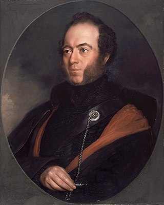
Sir Thomas Livingstone Mitchell, often called Major Mitchell, was a Scottish surveyor and explorer of Southeastern Australia. He was born in Scotland and served in the British Army during the Peninsular War. In 1827 he took up an appointment as Assistant Surveyor General of New South Wales. The following year he became Surveyor General and remained in this position until his death. Mitchell was knighted in 1839 for his contribution to the surveying of Australia.

Orange is a city in the Central Tablelands region of New South Wales, Australia. It is 254 km (158 mi) west of the state capital, Sydney [206 km (128 mi) on a great circle], at an altitude of 862 metres (2,828 ft). Orange had an urban population of 41,920 at the 2021 Census, making the city a significant regional centre. A significant nearby landmark is Mount Canobolas with a peak elevation of 1,395 m (4,577 ft) AHD and commanding views of the district. Orange is situated within the traditional lands of the Wiradjuri tribe.

Wellington is a town in the Central Western Slopes region of New South Wales, Australia, located at the junction of the Wambuul Macquarie and Bell Rivers. It is within the local government area of Dubbo Regional Council. The town is 362 kilometres (225 mi) northwest of Sydney on the Mitchell Highway and Main Western Railway, and 50 km southeast of Dubbo, the main centre of the Central Western Slopes region.
Menindee is a small town in the far west of New South Wales, Australia, in Central Darling Shire, on the banks of the Darling River, with a sign-posted population of 980 and a 2016 census population of 551. Menindee was the first town to be established on the Darling River. There are two distinct theories for the derivation of the township’s name: (a) from the Barkindji word "minandichi" for the shallow ephemeral lake north-west of the present-day township; (b) from the Barkindji word 'milhthaka', meaning "yolk of an egg".

Bourke is a town in the north-west of New South Wales, Australia. The administrative centre and largest town in Bourke Shire, Bourke is approximately 800 kilometres (500 mi) north-west of the state capital, Sydney, on the south bank of the Darling River. it is also situated:
The history of Australia from 1788 to 1850 covers the early British colonial period of Australia's history. This started with the arrival in 1788 of the First Fleet of British ships at Port Jackson on the lands of the Eora, and the establishment of the penal colony of New South Wales as part of the British Empire. It further covers the European scientific exploration of the continent and the establishment of the other Australian colonies that make up the modern states of Australia.
Gol Gol is a small country town in the Wentworth Shire, in the far western region of New South Wales, Australia. It is situated on the banks of the Murray River, within the Sunraysia region. In the fifteen years from 2006 to 2021, the population of Gol Gol increased from 663 to 1,956.

Cabonne Council is a local government area in the Central West region of New South Wales, Australia. The Shire is located adjacent to the Mitchell Highway and the Broken Hill railway line, partly surrounding the City of Orange. The administrative centre is located at Molong.

The Wentworth Gaol is a heritage-listed former gaol and school building and now museum and old wares shop located at 112 Beverley Street, Wentworth, in the Wentworth Shire, New South Wales, Australia. It was designed by James Barnet and built from 1879 to 1881 by Whitcombe Brothers, Hay. It is also known as the Old Wentworth Gaol. The property is owned by Department of Primary Industries - Western Lands Commissioner, an agency of the Government of New South Wales. The property was added to the New South Wales State Heritage Register on 21 October 2016.

Pooncarie is a village in south-western New South Wales, Australia in Wentworth Shire. It is on the eastern side of the Darling River between Wentworth and Menindee. The surrounding region of Pooncarie is semi-arid with an outback landscape rich in eucalypt woodlands.

The Cullin-la-ringo massacre, also known as the Wills tragedy, was a massacre of white colonists by Indigenous Australians that occurred on 17 October 1861, north of modern-day Springsure in Central Queensland, Australia. Nineteen men, women and children were killed in the attack, including Horatio Wills, the owner of Cullin-la-ringo station. It is the single largest massacre of colonists by Aboriginal people in Australian history. In the weeks afterwards, police, native police and civilian posses carried out "one of the most lethal punitive expeditions in frontier history", hunting down and killing up to 370 members of the Gayiri Aboriginal tribe implicated in the massacre.

Bora is an initiation ceremony of the Aboriginal people of Eastern Australia. The word "bora" also refers to the site on which the initiation is performed. At such a site, boys, having reached puberty, achieve the status of men. The initiation ceremony differs from Aboriginal culture to culture, but often, at a physical level, involved scarification, circumcision, subincision and, in some regions, also the removal of a tooth. During the rites, the youths who were to be initiated were taught traditional sacred songs, the secrets of the tribe's religious visions, dances, and traditional lore. Many different clans would assemble to participate in an initiation ceremony. Women and children were not permitted to be present at the sacred bora ground where these rituals were undertaken.

The Borenore Caves, contained within the Borenore Karst Conservation Reserve, are a series of limestone caves that are located in the Central West region of New South Wales, Australia. The caves are renowned for their karst qualities, namely the numerous fossils from a long-lived reef complex from the Silurian period. Fossils include corals, crinoids, brachiopods, gastropods, pentamerids, colonial tryplasmids and trilobites. Borenore's karst is surrounded by igneous rock that flowed from volcanic eruptions at nearby Mount Canobolas.
The Paakantyi, or Barkindji or Barkandji, are an Australian Aboriginal tribal group of the Darling River basin in Far West New South Wales, Australia.
The Maraura or Marrawarra people are an Aboriginal group whose traditional lands are located in Far West New South Wales and South Australia, Australia.
The Muruwari, also spelt Murawari, Murawarri, Murrawarri and other variants, are an Aboriginal Australian people of the state of New South Wales and the southwestern area of Queensland.

Grave of Yuranigh is the heritage-listed grave of Yuranigh, a 19th-century Wiradjuri man. It is located 3 km south-east of Molong, Cabonne Shire, New South Wales, Australia and dates from 1852. It is also known as Yuranigh's grave. It was added to the New South Wales State Heritage Register on 10 March 2006.
References
- ↑ Australian Bureau of Statistics (28 June 2022). "Borenore (suburb and locality)". Australian Census 2021 QuickStats. Retrieved 28 June 2022.
- ↑ "Borenore / Nashdale" . Retrieved 20 February 2013.
- ↑ Studies, Australian Institute of Aboriginal and Torres Strait Islander (12 July 2020). "Map of Indigenous Australia". aiatsis.gov.au. Retrieved 6 June 2021.
- 1 2 3 4 5 6 7 8 Cantrill, Elsie. "Centenary History of Borenore" . Retrieved 20 February 2013.
- ↑ "Corpus of Oz Early English › 2-214 (Text)" . Retrieved 23 February 2013.
- ↑ "Thomas Mitchell". gutenberg.net.au. Retrieved 6 June 2021.
- ↑ "Grave of Yuranigh". New South Wales State Heritage Register . Department of Planning & Environment. H01713. Retrieved 2 June 2018.
 Text is licensed by State of New South Wales (Department of Planning and Environment) under CC-BY 4.0 licence .
 - ↑ "Australian National Field Days" . Retrieved 20 February 2013.
- ↑ "Broken Hill Line" . Retrieved 20 February 2013.