Gordon County, New South Wales

Last updated

Map all coordinates using: OpenStreetMap
Gordon
New South Wales
Gordon NSW.PNG
Location in New South Wales
Lands administrative divisions around Gordon:
Narromine Lincoln Bligh
Kennedy Gordon Wellington
Ashburnham Ashburnham Wellington

Gordon County is one of the 141 Cadastral divisions of New South Wales. The Macquarie River is the north-eastern boundary.

Gordon County was named in honour of George Hamilton Gordon, Fourth Earl of Aberdeen (1784-1860). [1]

Parishes within this county

A full list of parishes found within this county; their current LGA and mapping coordinates to the approximate centre of each location is as follows:

ParishLGACoordinates
Belmore Cabonne Shire Council 32°37′54″S148°25′04″E / 32.63167°S 148.41778°E / -32.63167; 148.41778 (Belmore)
Benolong Dubbo Regional Council 32°25′54″S148°39′04″E / 32.43167°S 148.65111°E / -32.43167; 148.65111 (Benolong)
Benya Cabonne Shire Council 32°57′54″S148°33′04″E / 32.96500°S 148.55111°E / -32.96500; 148.55111 (Benya)
Bolderogery Cabonne Shire Council 32°48′54″S148°36′04″E / 32.81500°S 148.60111°E / -32.81500; 148.60111 (Bolderogery)
Buckinbah Cabonne Shire Council 32°47′54″S148°40′04″E / 32.79833°S 148.66778°E / -32.79833; 148.66778 (Buckinbah)
Burgoon Cabonne Shire Council 32°51′54″S148°38′04″E / 32.86500°S 148.63444°E / -32.86500; 148.63444 (Burgoon)
Burrawong Cabonne Shire Council 32°50′54″S148°44′04″E / 32.84833°S 148.73444°E / -32.84833; 148.73444 (Burrawong)
Caloma Dubbo Regional Council 32°29′54″S148°30′04″E / 32.49833°S 148.50111°E / -32.49833; 148.50111 (Caloma)
Cardington Cabonne Shire Council 32°50′54″S148°55′04″E / 32.84833°S 148.91778°E / -32.84833; 148.91778 (Cardington)
Catombal Dubbo Regional Council 32°47′54″S148°49′04″E / 32.79833°S 148.81778°E / -32.79833; 148.81778 (Catombal)
Cullen Dubbo Regional Council 32°25′54″S148°24′04″E / 32.43167°S 148.40111°E / -32.43167; 148.40111 (Cullen)
Curra Dubbo Regional Council 32°36′54″S148°54′04″E / 32.61500°S 148.90111°E / -32.61500; 148.90111 (Curra)
Dilga Cabonne Shire Council 32°56′54″S148°40′04″E / 32.94833°S 148.66778°E / -32.94833; 148.66778 (Dilga)
Draway Dubbo Regional Council 32°35′54″S148°35′04″E / 32.59833°S 148.58444°E / -32.59833; 148.58444 (Draway)
Dubbo Dubbo Regional Council 32°13′54″S148°35′04″E / 32.23167°S 148.58444°E / -32.23167; 148.58444 (Dubbo Regional Council)
Eurimbula Cabonne Shire Council 32°53′54″S148°49′04″E / 32.89833°S 148.81778°E / -32.89833; 148.81778 (Eurimbula)
Ganoo Dubbo Regional Council 32°39′54″S148°41′04″E / 32.66500°S 148.68444°E / -32.66500; 148.68444 (Ganoo)
Gilgal Dubbo Regional Council 32°31′54″S148°38′04″E / 32.53167°S 148.63444°E / -32.53167; 148.63444 (Gilgal)
Gullengambel Dubbo Regional Council 32°36′54″S148°32′04″E / 32.61500°S 148.53444°E / -32.61500; 148.53444 (Gullengambel)
Gundy Dubbo Regional Council 32°34′54″S148°51′04″E / 32.58167°S 148.85111°E / -32.58167; 148.85111 (Gundy)
Hyandra Cabonne Shire Council 32°52′54″S148°26′04″E / 32.88167°S 148.43444°E / -32.88167; 148.43444 (Hyandra)
Loombah Dubbo Regional Council 32°45′54″S148°44′04″E / 32.76500°S 148.73444°E / -32.76500; 148.73444 (Loombah)
Narragal Dubbo Regional Council 32°46′54″S148°57′04″E / 32.78167°S 148.95111°E / -32.78167; 148.95111 (Narragal)
Neurea Dubbo Regional Council 32°46′54″S148°53′04″E / 32.78167°S 148.88444°E / -32.78167; 148.88444 (Neurea)
Obley Cabonne Shire Council 32°44′54″S148°36′04″E / 32.74833°S 148.60111°E / -32.74833; 148.60111 (Obley)
Oxley Dubbo Regional Council 32°25′54″S148°32′04″E / 32.43167°S 148.53444°E / -32.43167; 148.53444 (Oxley)
Ponto Dubbo Regional Council 32°30′54″S148°49′04″E / 32.51500°S 148.81778°E / -32.51500; 148.81778 (Ponto)
Redbank Dubbo Regional Council 32°34′54″S148°44′04″E / 32.58167°S 148.73444°E / -32.58167; 148.73444 (Redbank)
Roche Dubbo Regional Council 32°30′54″S148°33′04″E / 32.51500°S 148.55111°E / -32.51500; 148.55111 (Roche)
Rocky Ponds Cabonne Shire Council 31°59′54″S148°30′04″E / 31.99833°S 148.50111°E / -31.99833; 148.50111 (Rocky Ponds)
Strathorn Cabonne Shire Council 32°44′54″S148°23′04″E / 32.74833°S 148.38444°E / -32.74833; 148.38444 (Strathorn)
Terrabella Dubbo Regional Council 32°28′54″S148°45′04″E / 32.48167°S 148.75111°E / -32.48167; 148.75111 (Terrabella)
The Gap Cabonne Shire Council 32°56′54″S148°45′04″E / 32.94833°S 148.75111°E / -32.94833; 148.75111 (The Gap)
The Springs Dubbo Regional Council 32°29′54″S148°39′04″E / 32.49833°S 148.65111°E / -32.49833; 148.65111 (The Springs)
Veech Dubbo Regional Council 32°40′54″S148°46′04″E / 32.68167°S 148.76778°E / -32.68167; 148.76778 (Veech)
Wagstaff Cabonne Shire Council 32°46′54″S148°31′04″E / 32.78167°S 148.51778°E / -32.78167; 148.51778 (Wagstaff)
Wandawandong Cabonne Shire Council 32°44′54″S148°32′04″E / 32.74833°S 148.53444°E / -32.74833; 148.53444 (Wandawandong)
Warraberry Cabonne Shire Council 32°53′54″S148°33′04″E / 32.89833°S 148.55111°E / -32.89833; 148.55111 (Warraberry)
Whylandra Dubbo Regional Council 32°20′54″S148°34′04″E / 32.34833°S 148.56778°E / -32.34833; 148.56778 (Whylandra)

Related Research Articles

<span class="mw-page-title-main">Richmond County, New South Wales</span> Cadastral in New South Wales, Australia

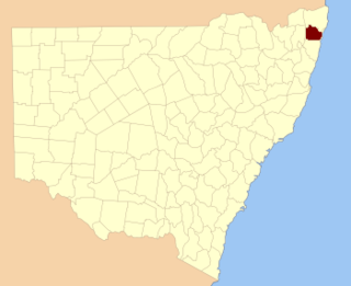
Richmond County is one of the 141 Cadastral divisions of New South Wales. It lies south of the Richmond River and includes South Casino.

<span class="mw-page-title-main">Manar, New South Wales</span> Town in New South Wales, Australia

Manar is a locality in the Queanbeyan-Palerang Region, Southern Tablelands, New South Wales, Australia. It lies on both sides of the Kings Highway between Bungendore and Braidwood at the intersection with the Braidwood–Goulburn road.

Whylandra Parish is a civil parish of Gordon County, New South Wales. a Cadastral divisions of New South Wales.

Benolong Parish is a civil parish of Gordon County, New South Wales. a Cadastral divisions of New South Wales.

Oxley Parish is a civil parish of Gordon County, New South Wales. a Cadastral divisions of New South Wales.

Terrabella Parish is a civil parish of Gordon County, New South Wales. a Cadastral divisions of New South Wales.

<span class="mw-page-title-main">Parish of Ponto</span> Place in New South Wales, Australia

Ponto, New SouthWales is a civil parish of Gordon County, New South Wales, a Cadastral divisions of New South Wales.

Gundy Parish is a civil parish of Gordon County, New South Wales. a Cadastral divisions of New South Wales.

Curra Parish, New South Wales is a civil parish of Gordon County, New South Wales, a Cadastral divisions of New South Wales.

Neurea Parish, New South Wales is a civil parish of Gordon County, New South Wales, a Cadastral divisions of New South Wales.

Neurea Parish, New South Wales is a civil parish of Gordon County, New South Wales, a Cadastral divisions of New South Wales.

Cardington Parish, New South Wales is a civil parish of Gordon County, New South Wales, a Cadastral divisions of New South Wales.

Eurimbula, New South Wales is a civil parish of Gordon County, New South Wales, a Cadastral divisions of New South Wales.

Burrawong Parish is a civil parish of Gordon County, New South Wales, a Cadastral divisions of New South Wales.

Burgoon Parish is a civil parish of Gordon County, New South Wales, a Cadastral divisions of New South Wales.

The Gap Parish is a civil parish of Gordon County, New South Wales, a Cadastral divisions of New South Wales.

<span class="mw-page-title-main">Parish of Buckinbah</span>

Buckinbah Parish is a civil parish of Gordon County, New South Wales, a Cadastral divisions of New South Wales.

<span class="mw-page-title-main">Parish of Dubbo</span> Place in New South Wales, Australia

Dubbo Parish (Gordon County), is a civil parish of Gordon County, New South Wales. a Cadastral divisions of New South Wales.

Wandawandong, New South Wales is a civil parish of Gordon County, New South Wales.

<span class="mw-page-title-main">Parish of Bolderogery</span> Place in New South Wales, Australia

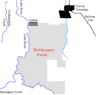
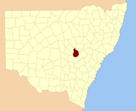
Bolderogery, New South Wales is a civil parish of Gordon County, New South Wales. a Cadastral divisions of New South Wales. Bolderogery Parish is located between Yeoval, New South Wales and the Little River (Dubbo).

References

  1. "Gordon County". Geographical Names Register (GNR) of NSW. Geographical Names Board of New South Wales. OOjs UI icon edit-ltr-progressive.svg