Parish of Narragal

Last updated

Neurea Parish, New South Wales is a civil parish of Gordon County, New South Wales, [1] a Cadastral divisions of New South Wales. [2]

Lands administrative divisions of Australia

Lands administrative divisions of Australia are the cadastral divisions of Australia for the purposes of identification of land to ensure security of land ownership. Most states term these divisions as counties, parishes, hundreds, and other terms. The eastern states of Queensland, New South Wales, Victoria and Tasmania were divided into counties and parishes in the 19th century, although the Tasmanian counties were renamed land districts in the 20th century. Parts of South Australia (south-east) and Western Australia (south-west) were similarly divided into counties, and there were also five counties in a small part of the Northern Territory. However South Australia has subdivisions of hundreds instead of parishes, along with the Northern Territory, which was part of South Australia when the hundreds were proclaimed. There were also formerly hundreds in Tasmania. There have been at least 600 counties, 544 hundreds and at least 15,692 parishes in Australia, but there are none of these units for most of the sparsely inhabited central and western parts of the country.

Gordon County, New South Wales Cadastral in New South Wales, Australia

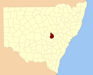
Gordon County is one of the 141 Cadastral divisions of New South Wales. The Macquarie River is the north-eastern boundary.

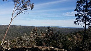
The parish is on the Bell River and Curra Creek and the nearest large town is Wellington, New South Wales is north of the parish although a village of Neurea is within the parish. [3]

Civil parish Territorial designation and lowest tier of local government in England

In England, a civil parish is a type of administrative parish used for local government, they are a territorial designation which is the lowest tier of local government below districts and counties, or their combined form, the unitary authority. Civil parishes can trace their origin to the ancient system of ecclesiastical parishes which historically played a role in both civil and ecclesiastical administration; civil and religious parishes were formally split into two types in the 19th century and are now entirely separate. The unit was devised and rolled out across England in the 1860s.

Bell River, a watercourse that is part of the Macquarie catchment within the Murray–Darling basin, is located in the central west region of New South Wales, Australia.

Wellington, New South Wales Town in New South Wales, Australia

Wellington is a town in inland New South Wales, Australia, located at the junction of the Macquarie and Bell Rivers. It is within the local government area of Dubbo Regional Council. The town is 362 kilometres (225 mi) from Sydney on the Great Western Highway and Mitchell Highway.

Related Research Articles

Darbalara, New South Wales Town in New South Wales, Australia

Darbalara is a rural community on the east bank of the junction of the Murrumbidgee River and Tumut River in the Riverina. It is situated by road, about 25 kilometres north east of Gundagai and 25 kilometres south of Coolac.

Blowering, New South Wales

Blowering, New South wales is a rural locality in the Snowy Mountains of New South wales and a civil Parish of Buccleuch County.

Parish of Whylandra New South Wales, Australia

Whylandra Parish is a civil parish of Gordon County, New South Wales. a Cadastral divisions of New South Wales.

Parish of Benolong New South Wales, Australia

Benolong Parish is a civil parish of Gordon County, New South Wales. a Cadastral divisions of New South Wales.

Parish of Oxley (Gordon County) New South Wales, Australia

Oxley Parish is a civil parish of Gordon County, New South Wales. a Cadastral divisions of New South Wales.

Parish of Terrabella New South Wales, Australia

Terrabella Parish is a civil parish of Gordon County, New South Wales. a Cadastral divisions of New South Wales.

Parish of Ponto New South Wales, Australia

Ponto, New SouthWales is a civil parish of Gordon County, New South Wales. a Cadastral divisions of New South Wales.

Gundy Parish is a civil parish of Gordon County, New South Wales. a Cadastral divisions of New South Wales.

Parish of Curra New South Wales, Australia

Curra Parish, New South Wales is a civil parish of Gordon County, New South Wales, a Cadastral divisions of New South Wales.

Parish of Neurea New South Wales, Australia

Neurea Parish, New South Wales is a civil parish of Gordon County, New South Wales, a Cadastral divisions of New South Wales.

Cardington Parish, New South Wales is a civil parish of Gordon County, New South Wales, a Cadastral divisions of New South Wales.

Eurimbula, New South Wales is a civil parish of Gordon County, New South Wales, a Cadastral divisions of New South Wales.

Burrawong Parish is a civil parish of Gordon County, New South Wales, a Cadastral divisions of New South Wales.

Burgoon Parish is a civil parish of Gordon County, New South Wales, a Cadastral divisions of New South Wales.

The Gap Parish is a civil parish of Gordon County, New South Wales, a Cadastral divisions of New South Wales.

Parish of Buckinbah

Buckinbah Parish is a civil parish of Gordon County, New South Wales, a Cadastral divisions of New South Wales.

Ganoo is a civil parish of Gordon County, New South Wales. a Cadastral divisions of New South Wales.

Parish of Dubbo New South Wales, Australia

Dubbo Parish , is a civil parish of Gordon County, New South Wales. a Cadastral divisions of New South Wales.

Wandawandong, New South Wales is a civil parish of Gordon County, New South Wales.

Parish of Bolderogery New South Wales, Australia

Bolderogery, New South Wales is a civil parish of Gordon County, New South Wales. a Cadastral divisions of New South Wales.

References

  1. Robert McLean, The New atlas of Australia : the complete work containing over one hundred maps and full descriptive geography of New South Wales, Victoria, Queensland, South Australia and Western Australia, together with numerous illustrations and copious indices (Sydney :J. Sands, [1886) Map 14.
  2. "Gordon County". Geographical Names Register (GNR) of NSW. Geographical Names Board of New South Wales. OOjs UI icon edit-ltr-progressive.svg
  3. County of Gordon New South Wales, 1918 map.