Parish of Dubbo

Last updated

Dubbo Parish
New South Wales
Overlooking Dubbo from the suburb of West Dubbo.jpg
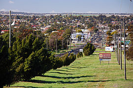
Overlooking Dubbo from the parish
Australia New South Wales location map blank.svg
Red pog.svg
Dubbo Parish
Coordinates 32°15′25″S148°36′4″E / 32.25694°S 148.60111°E / -32.25694; 148.60111 Coordinates: 32°15′25″S148°36′4″E / 32.25694°S 148.60111°E / -32.25694; 148.60111
Postcode(s) 2830
Elevation275 m (902 ft) [1] [2]
Time zone AEST (UTC+10)
 • Summer (DST) AEDT (UTC+11)
Location400 km (249 mi) NW of Sydney [3]
LGA(s) Dubbo Regional Council
Region Central West / Orana
County Gordon
State electorate(s) Dubbo
Federal Division(s) Parkes
Mean max tempMean min tempAnnual rainfall
24.3 °C
76 °F
10.1 °C
50 °F
551.7 mm
21.7 in

Dubbo Parish (Gordon County), is a civil parish of Gordon County, New South Wales. [4] a Cadastral divisions of New South Wales. [5]

Lands administrative divisions of Australia

Lands administrative divisions of Australia are the cadastral divisions of Australia for the purposes of identification of land to ensure security of land ownership. Most states term these divisions as counties, parishes, hundreds, and other terms. The eastern states of Queensland, New South Wales, Victoria and Tasmania were divided into counties and parishes in the 19th century, although the Tasmanian counties were renamed land districts in the 20th century. Parts of South Australia (south-east) and Western Australia (south-west) were similarly divided into counties, and there were also five counties in a small part of the Northern Territory. However South Australia has subdivisions of hundreds instead of parishes, along with the Northern Territory, which was part of South Australia when the hundreds were proclaimed. There were also formerly hundreds in Tasmania. There have been at least 600 counties, 544 hundreds and at least 15,692 parishes in Australia, but there are none of these units for most of the sparsely inhabited central and western parts of the country.

Gordon County, New South Wales Cadastral in New South Wales, Australia

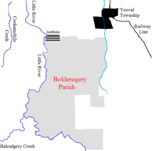
Gordon County is one of the 141 Cadastral divisions of New South Wales. The Macquarie River is the north-eastern boundary.

The parish, located in Dubbo Regional Council, features the township of West Dubbo, Taronga Western Plains Zoo and Dubbo Observatory. The Burke Railway line passes through the parish. During World War II an airbase was established in the parish.

Dubbo Regional Council Local government area in New South Wales, Australia

The Dubbo Regional Council is a local government area located in the Central West and Orana regions of New South Wales, Australia. The council was formed on 12 May 2016 through a merger of the City of Dubbo and Wellington Council. Originally named Western Plains Regional Council, the name was changed to Dubbo Regional Council on 7 September 2016.

Taronga Western Plains Zoo

Taronga Western Plains Zoo, formerly known as Western Plains Zoo and commonly known as Dubbo Zoo, is a large zoo near Dubbo, New South Wales, Australia. It opened to the public on 28 February 1977, to provide more living and breeding space for large animals such as elephants and antelopes which needed more space than was available at the restricted Sydney site. The zoo is run by the Taronga Conservation Society, along with Taronga Zoo Sydney. Western Plains Zoo is located on the Newell Highway in west Dubbo about 5 km from the city.

Civil parish Territorial designation and lowest tier of local government in England

In England, a civil parish is a type of administrative parish used for local government, they are a territorial designation which is the lowest tier of local government below districts and counties, or their combined form, the unitary authority. Civil parishes can trace their origin to the ancient system of ecclesiastical parishes which historically played a role in both civil and ecclesiastical administration; civil and religious parishes were formally split into two types in the 19th century and are now entirely separate. The unit was devised and rolled out across England in the 1860s.

Related Research Articles

Yarrangobilly, New South Wales is a rural locality in the Snowy Mountains, west of Canberra, Australia, and is also a civil Parish of Buccleuch County.

Biamble is a civil parish of Napier County, New South Wales, that is located at 31°43′54″S 149°19′04″E. The civil parish is roughly equivalent to the rural locality of Neilrex in Warrumbungle Shire Council.

Parish of Whylandra New South Wales, Australia

Whylandra Parish is a civil parish of Gordon County, New South Wales. a Cadastral divisions of New South Wales.

Parish of Benolong New South Wales, Australia

Benolong Parish is a civil parish of Gordon County, New South Wales. a Cadastral divisions of New South Wales.

Parish of Oxley (Gordon County) New South Wales, Australia

Oxley Parish is a civil parish of Gordon County, New South Wales. a Cadastral divisions of New South Wales.

Parish of Terrabella New South Wales, Australia

Terrabella Parish is a civil parish of Gordon County, New South Wales. a Cadastral divisions of New South Wales.

Parish of Ponto New South Wales, Australia

Ponto, New SouthWales is a civil parish of Gordon County, New South Wales, a Cadastral divisions of New South Wales.

Gundy Parish is a civil parish of Gordon County, New South Wales. a Cadastral divisions of New South Wales.

Parish of Curra New South Wales, Australia

Curra Parish, New South Wales is a civil parish of Gordon County, New South Wales, a Cadastral divisions of New South Wales.

Parish of Neurea New South Wales, Australia

Neurea Parish, New South Wales is a civil parish of Gordon County, New South Wales, a Cadastral divisions of New South Wales.

Neurea Parish, New South Wales is a civil parish of Gordon County, New South Wales, a Cadastral divisions of New South Wales.

Cardington Parish, New South Wales is a civil parish of Gordon County, New South Wales, a Cadastral divisions of New South Wales.

Eurimbula, New South Wales is a civil parish of Gordon County, New South Wales, a Cadastral divisions of New South Wales.

Burrawong Parish is a civil parish of Gordon County, New South Wales, a Cadastral divisions of New South Wales.

Burgoon Parish is a civil parish of Gordon County, New South Wales, a Cadastral divisions of New South Wales.

The Gap Parish is a civil parish of Gordon County, New South Wales, a Cadastral divisions of New South Wales.

Parish of Buckinbah

Buckinbah Parish is a civil parish of Gordon County, New South Wales, a Cadastral divisions of New South Wales.

Ganoo is a civil parish of Gordon County, New South Wales. a Cadastral divisions of New South Wales.

Wandawandong, New South Wales is a civil parish of Gordon County, New South Wales.

Parish of Bolderogery New South Wales, Australia

Bolderogery, New South Wales is a civil parish of Gordon County, New South Wales. a Cadastral divisions of New South Wales.

References

  1. DCC Annual Report,Dubbo City Council, 2005|accessdate=30
  2. 2., 28 September 2007 (refer page 7)
  3. Dubbo Parish lies at a bearing of 307° from Sydney
  4. Robert McLean, The New atlas of Australia : the complete work containing over one hundred maps and full descriptive geography of New South Wales, Victoria, Queensland, South Australia and Western Australia, together with numerous illustrations and copious indices (Sydney :J. Sands, [1886) Map 141.
  5. "Gordon County". Geographical Names Register (GNR) of NSW. Geographical Names Board of New South Wales. OOjs UI icon edit-ltr-progressive.svg