Ashburnham County

Last updated
Map all coordinates using: OpenStreetMap  ·  Google Maps
Download coordinates as: KML  ·  GPX
Ashburnham
New South Wales

Ashburnham NSW.PNG

Location in New South Wales
Lands administrative divisions around Ashburnham:
Kennedy Gordon Wellington
Cunningham Ashburnham Bathurst
Gipps Forbes Bathurst

Ashburnham County, New South Wales is one of the 141 Cadastral divisions of New South Wales. The Lachlan River and Belubula River is the southern boundary. It includes Parkes and Forbes.

Lachlan River tributary to the Murrumbidgee River in New South Wales, Australia

The Lachlan River is an intermittent river that is part of the Murrumbidgee catchment within the Murray–Darling basin, located in the Southern Tablelands, Central West, and Riverina regions of New South Wales, Australia.

Belubula River river

Belubula River, a perennial river that is part of the Lachlan catchment within the Murray–Darling basin, is located in the central west region of New South Wales, Australia.

Parkes, New South Wales Town in New South Wales, Australia

Parkes is a town in the Central West region of New South Wales, Australia. It is the main settlement in the local government area of Parkes Shire. Parkes had a population of 11,408 as at 30 June 2016.

Ashburnham County was named in honour of Bertram Ashburnham (1797-1878), who became the 4th earl of Ashburnham in 1830. [1]

Earl of Ashburnham

The title Baron Ashburnham, of Ashburnham in the County of Sussex, was created in the Peerage of England in 1689 for John Ashburnham, grandson of the John Ashburnham who helped King Charles I escape from Oxford and Hampton Court Palace. He obtained from the King, for his London seat, the Westminster Abbey Prior's House, which had been seized by the Crown during the dissolution of the monasteries. He rebuilt it and renamed it Ashburnham House; it now stands as one of the central buildings of Westminster School, and has given the family name to one of the co-ed day houses.

Parishes within this county

A full list of parishes found within this county; their current LGA and mapping coordinates to the approximate centre of each location is as follows:

Local government in Australia

Local government in Australia is the third tier of government in Australia administered by the states and territories, which in turn are beneath the federal tier. Local government is not mentioned in the Constitution of Australia and two referenda in the 1970s and 1980s to alter the Constitution relating to local government were unsuccessful. Every state government recognises local government in their respective constitutions. Unlike Canada or the United States, there is only one level of local government in each state, with no distinction such as cities and counties.

Parish LGA Coordinates
Barrajin Cabonne Shire Council 33°29′54″S148°45′04″E / 33.49833°S 148.75111°E / -33.49833; 148.75111 (Barrajin Parish)
Barton Cabonne Shire Council 33°15′54″S148°57′04″E / 33.26500°S 148.95111°E / -33.26500; 148.95111 (Barton Parish)
Beargamil Parkes Shire Council 33°03′54″S148°18′04″E / 33.06500°S 148.30111°E / -33.06500; 148.30111 (Beargamil Parish)
Bell Cabonne Shire Council 32°58′54″S148°50′04″E / 32.98167°S 148.83444°E / -32.98167; 148.83444 (Bell Parish)
Belubula Cabonne Shire Council 33°31′54″S148°34′04″E / 33.53167°S 148.56778°E / -33.53167; 148.56778 (Belubula Parish)
Bocobidgle Forbes Shire Council 33°20′54″S147°56′04″E / 33.34833°S 147.93444°E / -33.34833; 147.93444 (Bocobidgle Parish)
Bindogundra Parkes Shire Council 33°09′54″S148°21′04″E / 33.16500°S 148.35111°E / -33.16500; 148.35111 (Bindogundra Parish)
Boree Cabonne Cabonne Shire Council 33°16′54″S148°49′04″E / 33.28167°S 148.81778°E / -33.28167; 148.81778 (Boree Cabonne Parish)
Boree Nyrang Cabonne Shire Council 33°11′54″S148°54′04″E / 33.19833°S 148.90111°E / -33.19833; 148.90111 (Boree Nyrang Parish)
Bowan Cabonne Shire Council 33°19′54″S148°50′04″E / 33.33167°S 148.83444°E / -33.33167; 148.83444 (Bowan Parish)
Brolgan Parkes Shire Council 33°07′54″S148°03′04″E / 33.13167°S 148.05111°E / -33.13167; 148.05111 (Brolgan Parish)
Brymedura Cabonne Shire Council 33°07′54″S148°47′04″E / 33.13167°S 148.78444°E / -33.13167; 148.78444 (Brymedura Parish)
Bumberry Parkes Shire Council 33°08′54″S148°27′04″E / 33.14833°S 148.45111°E / -33.14833; 148.45111 (Bumberry Parish)
Canomodine Cabonne Shire Council 33°31′54″S148°50′04″E / 33.53167°S 148.83444°E / -33.53167; 148.83444 (Canomodine Parish)
Cargo Cabonne Shire Council 33°25′54″S148°50′04″E / 33.43167°S 148.83444°E / -33.43167; 148.83444 (Cargo Parish)
Carrawabbity Forbes Shire Council 33°21′54″S147°51′04″E / 33.36500°S 147.85111°E / -33.36500; 147.85111 (Carrawabbity Parish)
Canobolas Cabonne Shire Council 33°19′54″S148°58′04″E / 33.33167°S 148.96778°E / -33.33167; 148.96778 (Canobolas Parish)
Collett Cabonne Shire Council 33°31′54″S148°42′04″E / 33.53167°S 148.70111°E / -33.53167; 148.70111 (Collett Parish)
Cookamidgera Parkes Shire Council 33°14′54″S148°16′04″E / 33.24833°S 148.26778°E / -33.24833; 148.26778 (Cookamidgera Parish)
Coonambro Forbes Shire Council 33°14′54″S148°22′04″E / 33.24833°S 148.36778°E / -33.24833; 148.36778 (Coonambro Parish)
Cudal Cabonne Shire Council 33°16′54″S148°43′04″E / 33.28167°S 148.71778°E / -33.28167; 148.71778 (Cudal Parish)
Cumble Cabonne Shire Council 33°04′54″S148°42′04″E / 33.08167°S 148.70111°E / -33.08167; 148.70111 (Cumble Parish)
Currajong Parkes Shire Council 33°04′54″S148°04′04″E / 33.08167°S 148.06778°E / -33.08167; 148.06778 (Currajong Parish)
Curumbenya Parkes Shire Council 33°02′54″S148°25′04″E / 33.04833°S 148.41778°E / -33.04833; 148.41778 (Curumbenya Parish)
Dowling Forbes Shire Council 33°16′54″S148°09′04″E / 33.28167°S 148.15111°E / -33.28167; 148.15111 (Dowling Parish)
Dulladerry Cabonne Shire Council 33°12′54″S148°37′04″E / 33.21500°S 148.61778°E / -33.21500; 148.61778 (Dulladerry Parish)
Edinburgh Cabonne Shire Council 33°24′54″S148°55′04″E / 33.41500°S 148.91778°E / -33.41500; 148.91778 (Edinburgh Parish)
Eugowra Forbes Shire Council 33°22′54″S148°20′04″E / 33.38167°S 148.33444°E / -33.38167; 148.33444 (Eugowra Parish)
Forbes Forbes Shire Council 33°21′54″S148°02′04″E / 33.36500°S 148.03444°E / -33.36500; 148.03444 (Forbes Parish)
Goimbla Cabonne Shire Council 33°22′54″S148°32′04″E / 33.38167°S 148.53444°E / -33.38167; 148.53444 (Goimbla Parish)
Goobang Parkes Shire Council 33°02′54″S148°13′04″E / 33.04833°S 148.21778°E / -33.04833; 148.21778 (Goobang Parish)
Goonumbla Parkes Shire Council 33°00′54″S148°07′04″E / 33.01500°S 148.11778°E / -33.01500; 148.11778 (Goonumbla Parish)
Gregra Cabonne Shire Council 33°11′54″S148°45′04″E / 33.19833°S 148.75111°E / -33.19833; 148.75111 (Gregra Parish)
Gunningbland Parkes Shire Council 33°04′54″S148°00′04″E / 33.08167°S 148.00111°E / -33.08167; 148.00111 (Gunningbland Parish)
Kamandra Parkes Shire Council 33°08′54″S148°15′04″E / 33.14833°S 148.25111°E / -33.14833; 148.25111 (Kamandra Parish)
Mandagery Cabonne Shire Council 33°17′54″S148°37′04″E / 33.29833°S 148.61778°E / -33.29833; 148.61778 (Mandagery Parish)
Manildra Cabonne Shire Council 33°07′54″S148°38′04″E / 33.13167°S 148.63444°E / -33.13167; 148.63444 (Manildra Parish)
Martin Parkes Shire Council 33°13′54″S148°06′04″E / 33.23167°S 148.10111°E / -33.23167; 148.10111 (Martin Parish)
Milpose Parkes Shire Council 32°59′54″S148°00′04″E / 32.99833°S 148.00111°E / -32.99833; 148.00111 (Milpose Parish)
Mogong Cabonne Shire Council 33°29′54″S148°31′04″E / 33.49833°S 148.51778°E / -33.49833; 148.51778 (Mogong Parish)
Molong Cabonne Shire Council 33°08′54″S148°53′04″E / 33.14833°S 148.88444°E / -33.14833; 148.88444 (Molong Parish)
Moura Cabonne Shire Council 33°18′54″S148°32′04″E / 33.31500°S 148.53444°E / -33.31500; 148.53444 (Moura Parish)
Mugincoble Parkes Shire Council 33°14′54″S148°12′04″E / 33.24833°S 148.20111°E / -33.24833; 148.20111 (Mugincoble Parish)
Mumbidgle Forbes Shire Council 33°16′54″S148°03′04″E / 33.28167°S 148.05111°E / -33.28167; 148.05111 (Mumbidgle Parish)
Murga Cabonne Shire Council 33°21′54″S148°36′04″E / 33.36500°S 148.60111°E / -33.36500; 148.60111 (Murga Parish)
Nanami Cabonne Shire Council 33°31′54″S148°31′04″E / 33.53167°S 148.51778°E / -33.53167; 148.51778 (Nanami Parish)
Nangar Cabonne Shire Council 33°23′54″S148°33′04″E / 33.39833°S 148.55111°E / -33.39833; 148.55111 (Nangar Parish)
Nelungalong Parkes Shire Council 33°09′54″S147°55′04″E / 33.16500°S 147.91778°E / -33.16500; 147.91778 (Nelungalong Parish)
Nyrang Cabonne Shire Council 33°29′54″S148°41′04″E / 33.49833°S 148.68444°E / -33.49833; 148.68444 (Nyrang Parish)
Parkes Parkes Shire Council 33°09′54″S148°08′04″E / 33.16500°S 148.13444°E / -33.16500; 148.13444 (Parkes Parish)
Terarra Cabonne Shire Council 33°15′54″S148°31′04″E / 33.26500°S 148.51778°E / -33.26500; 148.51778 (Terarra Parish)
Toogong Cabonne Shire Council 33°21′54″S148°42′04″E / 33.36500°S 148.70111°E / -33.36500; 148.70111 (Toogong Parish)
Trajere Cabonne Shire Council 33°29′54″S148°24′04″E / 33.49833°S 148.40111°E / -33.49833; 148.40111 (Trajere Parish)
Troubalgie Forbes Shire Council 33°21′54″S148°08′04″E / 33.36500°S 148.13444°E / -33.36500; 148.13444 (Troubalgie Parish)
Wanera Forbes Shire Council 33°18′54″S148°21′04″E / 33.31500°S 148.35111°E / -33.31500; 148.35111 (Wanera Parish)
Warregal Parkes Shire Council 33°11′54″S148°00′04″E / 33.19833°S 148.00111°E / -33.19833; 148.00111 (Warregal Parish)
Waugan Forbes Shire Council 33°25′54″S148°16′04″E / 33.43167°S 148.26778°E / -33.43167; 148.26778 (Waugan Parish)
Wise Forbes Shire Council 33°20′54″S148°15′04″E / 33.34833°S 148.25111°E / -33.34833; 148.25111 (Wise Parish)
Wolabler Cabonne Shire Council 33°06′54″S148°30′04″E / 33.11500°S 148.50111°E / -33.11500; 148.50111 (Wolabler Parish)
Yarragong Forbes Shire Council 33°13′54″S147°53′04″E / 33.23167°S 147.88444°E / -33.23167; 147.88444 (Yarragong Parish)

Related Research Articles

Ashburnham, Massachusetts Town in Massachusetts, United States

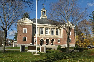
Ashburnham is a town in Worcester County, Massachusetts. At the 2010 census the town population was 6,081. It is home to Cushing Academy, a private preparatory boarding school.

Yass River river in New South Wales, Australia

The Yass River, a perennial river that is part of the Murrumbidgee catchment within the Murray–Darling basin, is located in the Southern Tablelands and South Western Slopes districts of New South Wales, Australia.

Lachlan was an electoral district of the Legislative Assembly in the Australian state of New South Wales. During the first two Parliaments (1856–1859), there was an electorate in the same area called Lachlan and Lower Darling, named after the Lachlan and Darling Rivers. Lachlan was created in 1859 and abolished in 1880, partly replaced by Forbes. In 1894 Forbes was abolished and Lachlan was recreated. In 1920 Lachlan and Ashburnham were absorbed into Murrumbidgee and elected three members under proportional representation. At the end of proportional representation in 1927, Lachlan was recreated. It was abolished in 1950, recreated in 1981 and abolished in 2007. The abolition of Lachlan for the 2007 election prompted its member, former Deputy Premier Ian Armstrong to retire at that election rather than seek the option of remaining in Parliament by contesting another seat.

Electoral district of Murrumbidgee state electoral district of New South Wales, Australia

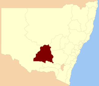
Murrumbidgee is a former electoral district of the Legislative Assembly in the Australian state of New South Wales, named after the Murrumbidgee River.

The South Branch of the Souhegan River is a 5.8-mile-long (9.3 km) river located in northern Massachusetts and southern New Hampshire in the United States. It is a tributary of the Souhegan River, which flows to the Merrimack River and ultimately to the Gulf of Maine.

Darbalara, New South Wales Town in New South Wales, Australia

Darbalara is a rural community on the east bank of the junction of the Murrumbidgee River and Tumut River in the Riverina. It is situated by road, about 25 kilometres north east of Gundagai and 25 kilometres south of Coolac.

Gloucester County, New South Wales Cadastral in New South Wales, Australia

Gloucester County was one of the original Nineteen Counties in New South Wales, and is now one of the 141 cadastral divisions of New South Wales. It includes the area around Port Stephens. It is bounded on the north and west by the Manning River, and on the south-west by the Williams River.

Northumberland County, New South Wales Cadastral in New South Wales, Australia

Northumberland County was one of the original Nineteen Counties in New South Wales and is now one of the 141 Cadastral divisions of New South Wales. It included the area to the north of Broken Bay, including Lake Macquarie and Newcastle. It was bounded by the part of the Hawkesbury River to the south, the Macdonald River to the south-west, and the Hunter River to the north.

Camden County, New South Wales Cadastral in New South Wales, Australia

Camden County was one of the original Nineteen Counties in New South Wales and is now one of the 141 Cadastral divisions of New South Wales. It included the coastal area near Wollongong south to the Shoalhaven River, and also inland encompassing Berrima and Picton. Its western boundary was the Wollondilly River. The first settlement in the area was Camden Park, established by John Macarthur in 1806, just across the Nepean River from Cumberland County. It was the first land across the Nepean to be settled. Camden is a present-day suburb of Sydney in the same area, although parts of it are in Cumberland.

St Vincent County Cadastral in New South Wales, Australia

St Vincent County was one of the original Nineteen Counties in New South Wales and is now one of the 141 Cadastral divisions of New South Wales. It included the south coast area encompassing Batemans Bay, Ulladulla, Jervis Bay and inland to Braidwood. The Shoalhaven River is the boundary to the north and west, and the Deua River the boundary to the south.

Cowper County Cadastral in New South Wales, Australia

Cowper County, New South Wales is one of the 141 Cadastral divisions of New South Wales.

Oxley County Cadastral in New South Wales, Australia

Oxley County, New South Wales is one of the 141 Cadastral divisions of New South Wales. It is located between the Bogan River on the west, and the Macquarie River on the east. This is the area approximately between Warren and Nyngan.

Ashburnham was an electoral district of the Legislative Assembly in the Australian state of New South Wales, originally created in 1894 in the Parkes area and named after Ashburnham County. In 1920, with the introduction of proportional representation, it was absorbed into Murrumbidgee, along with Lachlan. It was recreated in 1927 and abolished in 1968.

The Bemboka River, a perennial stream of the Bega River catchment, is located in the Monaro and South Coast regions of New South Wales, Australia.

Cobrabald River river in Australia

Cobrabald River, a mostly perennial river that is part of the Namoi catchment within the Murray–Darling basin, is located in the Northern Tablelands district of New South Wales, Australia.

The Coolumbooka River, a perennial river of the Snowy River catchment, is located in the Monaro region of New South Wales, Australia.

Kedumba River river in New South Wales, Australia

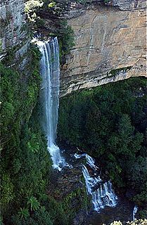
The Kedumba River, a perennial river that is part of the Hawkesbury-Nepean catchment, is located in the Blue Mountains and Macarthur regions of New South Wales, Australia.

Bettowynd Creek, a partly perennial stream of the Moruya River catchment, is located in the Southern Tablelands and South Coast regions of New South Wales, Australia.

The Clouds Creek, a perennial stream that is part of the Clarence River catchment, is located in the Northern Tablelands region of New South Wales, Australia.

References

  1. "Ashburnham". Geographical Names Register (GNR) of NSW. Geographical Names Board of New South Wales.