Bathurst County

Last updated

Map all coordinates using: OpenStreetMap  
Download coordinates as: KML  ·  GPX
Bathurst
New South Wales
Bathurst NSW.PNG
Location in New South Wales
Lands administrative divisions around Bathurst:
Ashburnham Wellington Roxburgh
Forbes Bathurst Westmoreland
Monteagle King Georgiana

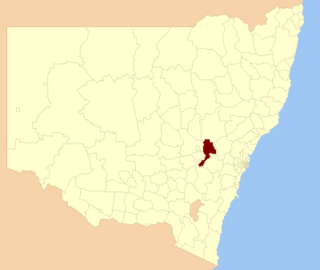
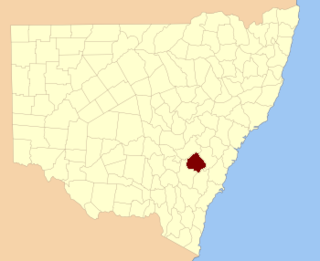
Bathurst County was one of the original Nineteen Counties in New South Wales and is now one of the 141 Cadastral divisions of New South Wales. It includes the area to the south-west of Bathurst to Cowra and Orange. The Lachlan River is the boundary to the south-west, the Belubula River forms part of the northern boundary, with the Fish River on the northeastern boundary. Blayney is located roughly in the middle.

Nineteen Counties area of New South Wales colony to which European settlement was legally restricted from 1826 until 1861

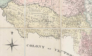
The Nineteen Counties were the limits of location in the colony of New South Wales, Australia. Settlers were permitted to take up land only within the counties due to the dangers in the wilderness.

New South Wales State of Australia

New South Wales is a state on the east coast of Australia. It borders Queensland to the north, Victoria to the south, and South Australia to the west. Its coast borders the Tasman Sea to the east. The Australian Capital Territory is an enclave within the state. New South Wales' state capital is Sydney, which is also Australia's most populous city. In December 2018, the population of New South Wales was over 8 million, making it Australia's most populous state. Just under two-thirds of the state's population, 5.1 million, live in the Greater Sydney area. Inhabitants of New South Wales are referred to as New South Welshmen.

Bathurst, New South Wales City in New South Wales, Australia

Bathurst is a city in the Central Tablelands of New South Wales, Australia. It is about 200 kilometres (120 mi) west-northwest of Sydney and is the seat of the Bathurst Regional Council. Bathurst is the oldest inland settlement in Australia and had a population of 36,801 at June 2018.

Bathurst County was named in honour of Henry Bathurst, 3rd Earl 1762–1834. [1] The Electoral district of Bathurst (County) was the first state electoral district for the area, between 1856 and 1859.

Henry Bathurst, 3rd Earl Bathurst British politician

Henry Bathurst, 3rd Earl Bathurst, was a High Tory, High Church Pittite from the end of the Second Empire. For thirty years an MP and whence ennobled one of the government's main stalwarts on Colonial policy. Not a good speaker in debates, he was nevertheless a competent administrator. If rather dull, he remained intensely loyal and at the centre of government for longer than all his contemporaries. A personal friend of William Pitt the Younger, he became a broker of deals across cabinet factions during the volatile Napoleonic era. After the Napoleonic Wars, Bathurst was on the 'conservative' wing of the Tory party. He came round towards arbitrating on a less than harsh colonial regime.

Electoral district of Bathurst (County) electoral district of New South Wales (1856–1859)

Bathurst (County) was an electoral district of the Legislative Assembly in the Australian state of New South Wales, named after Bathurst County and including the rural part of the county. The electorate did not include the town of Bathurst which was included in Western Boroughs, until Bathurst was created in 1859. Bathurst (County) was replaced by Carcoar, East Macquarie and West Macquarie in 1859.

The Lachlan River at Cowra; the river is the boundary between Bathurst and Forbes LachlanAtCowra.JPG
The Lachlan River at Cowra; the river is the boundary between Bathurst and Forbes

In 1852 it had an area of 1,196,400 acres (4,842 km2) and population of 6,405. At this time it was described as having some of the best wool in the colony, with excellent farming land. [2]

Wool Textile fibre from the hair of sheep or other mammals

Wool is the textile fiber obtained from sheep and other animals, including cashmere and mohair from goats, qiviut from muskoxen, from hide and fur clothing from bison, angora from rabbits, and other types of wool from camelids; additionally, the Highland and the Mangalica breeds of cattle and swine, respectively, possess wooly coats.

Parishes within this county

A full list of parishes found within this county; their current LGA and mapping coordinates to the approximate centre of each location is as follows:

Local government in Australia third tier of government in Australia

Local government in Australia is the third tier of government in Australia administered by the states and territories, which in turn are beneath the federal tier. Local government is not mentioned in the Constitution of Australia and two referenda in the 1970s and 1980s to alter the Constitution relating to local government were unsuccessful. Every state government recognises local government in their respective constitutions. Unlike Canada or the United States, there is only one level of local government in each state, with no distinction such as cities and counties.

ParishLGACoordinates
Aberfoil Cabonne Shire 33°06′54″S149°19′04″E / 33.11500°S 149.31778°E / -33.11500; 149.31778 (Aberfoil Parish)
Anson Cabonne Shire 33°19′54″S149°13′04″E / 33.33167°S 149.21778°E / -33.33167; 149.21778 (Anson Parish)
Apsley Bathurst Regional Council 33°30′54″S149°34′04″E / 33.51500°S 149.56778°E / -33.51500; 149.56778 (Apsley Parish)
Arkell Bathurst Regional Council 33°38′54″S149°35′04″E / 33.64833°S 149.58444°E / -33.64833; 149.58444 (Arkell Parish)
Bangaroo Cowra Shire 33°36′54″S148°33′04″E / 33.61500°S 148.55111°E / -33.61500; 148.55111 (Bangaroo Parish)
Bathurst Bathurst Regional Council 33°25′54″S149°34′04″E / 33.43167°S 149.56778°E / -33.43167; 149.56778 (Bathurst Parish)
Beaufort Blayney Shire 33°31′54″S149°06′04″E / 33.53167°S 149.10111°E / -33.53167; 149.10111 (Beaufort Parish)
Belubula Blayney Shire 33°34′54″S149°03′04″E / 33.58167°S 149.05111°E / -33.58167; 149.05111 (Belubula Parish)
Beneree Cabonne Shire 33°25′54″S149°05′04″E / 33.43167°S 149.08444°E / -33.43167; 149.08444 (Beneree Parish)
Billimari Cowra Shire 33°39′54″S148°38′04″E / 33.66500°S 148.63444°E / -33.66500; 148.63444 (Billimari Parish)
Blake Blayney Shire 33°31′54″S148°59′04″E / 33.53167°S 148.98444°E / -33.53167; 148.98444 (Blake Parish)
Bracebridge Cowra Shire 33°48′54″S148°58′04″E / 33.81500°S 148.96778°E / -33.81500; 148.96778 (Bracebridge Parish)
Bringellet Oberon Shire 33°39′54″S149°30′04″E / 33.66500°S 149.50111°E / -33.66500; 149.50111 (Bringellet Parish)
Byng Cabonne Shire 33°20′54″S149°18′04″E / 33.34833°S 149.30111°E / -33.34833; 149.30111 (Byng Parish)
Cadogan Bathurst Regional Council 33°21′54″S149°22′04″E / 33.36500°S 149.36778°E / -33.36500; 149.36778 (Cadogan Parish)
Calvert Blayney Shire 33°30′54″S149°06′04″E / 33.51500°S 149.10111°E / -33.51500; 149.10111 (Calvert Parish)
Canowindra Cowra Shire 33°36′54″S148°40′04″E / 33.61500°S 148.66778°E / -33.61500; 148.66778 (Canowindra Parish)
Carlton Blayney Shire 33°31′54″S148°56′04″E / 33.53167°S 148.93444°E / -33.53167; 148.93444 (Carlton Parish)
Chaucer Cowra Shire 33°35′54″S148°47′04″E / 33.59833°S 148.78444°E / -33.59833; 148.78444 (Chaucer Parish)
Clarendon Cabonne Shire 33°27′54″S148°58′04″E / 33.46500°S 148.96778°E / -33.46500; 148.96778 (Clarendon Parish)
Clinton Cabonne Shire 33°14′54″S149°11′04″E / 33.24833°S 149.18444°E / -33.24833; 149.18444 (Clinton Parish)
Cole Bathurst Regional Council 33°29′54″S149°24′04″E / 33.49833°S 149.40111°E / -33.49833; 149.40111 (Cole Parish)
Coleridge Bathurst Regional Council 33°09′54″S149°27′04″E / 33.16500°S 149.45111°E / -33.16500; 149.45111 (Coleridge Parish)
Colville Cabonne Shire 33°23′54″S149°16′04″E / 33.39833°S 149.26778°E / -33.39833; 149.26778 (Colville Parish)
Coota Cowra Shire 33°49′54″S148°46′04″E / 33.83167°S 148.76778°E / -33.83167; 148.76778 (Coota Parish)
Cowra Cowra Shire 33°46′54″S148°44′04″E / 33.78167°S 148.73444°E / -33.78167; 148.73444 (Cowra Parish)
Dunleary Cowra Shire 33°55′54″S148°57′04″E / 33.93167°S 148.95111°E / -33.93167; 148.95111 (Dunleary Parish)
Egbert Cowra Shire 33°45′54″S149°10′04″E / 33.76500°S 149.16778°E / -33.76500; 149.16778 (Egbert Parish)
Errol Blayney Shire 33°33′54″S149°11′04″E / 33.56500°S 149.18444°E / -33.56500; 149.18444 (Errol Parish)
Freemantle Cabonne Shire 33°14′54″S149°20′04″E / 33.24833°S 149.33444°E / -33.24833; 149.33444 (Freemantle Parish)
Galbraith Blayney Shire 33°33′54″S149°22′04″E / 33.56500°S 149.36778°E / -33.56500; 149.36778 (Galbraith Parish)
Glenlogan Cowra Shire 33°46′54″S148°39′04″E / 33.78167°S 148.65111°E / -33.78167; 148.65111 (Glenlogan Parish)
Graham Blayney Shire 33°27′54″S149°12′04″E / 33.46500°S 149.20111°E / -33.46500; 149.20111 (Graham Parish)
Grantham Bathurst Regional Council 33°29′54″S149°30′04″E / 33.49833°S 149.50111°E / -33.49833; 149.50111 (Grantham Parish)
Hampton Cowra Shire 33°36′54″S148°57′04″E / 33.61500°S 148.95111°E / -33.61500; 148.95111 (Hampton Parish)
Huntley Cabonne Shire 33°22′54″S149°07′04″E / 33.38167°S 149.11778°E / -33.38167; 149.11778 (Huntley Parish)
Kenilworth Cowra Shire 33°45′54″S148°50′04″E / 33.76500°S 148.83444°E / -33.76500; 148.83444 (Kenilworth Parish)
Lennox Cabonne Shire 33°11′54″S149°17′04″E / 33.19833°S 149.28444°E / -33.19833; 149.28444 (Lennox Parish)
Lindsay Blayney Shire 33°30′54″S149°13′04″E / 33.51500°S 149.21778°E / -33.51500; 149.21778 (Lindsay Parish)
Lowry Bathurst Regional Council 35°33′54″S149°27′04″E / 35.56500°S 149.45111°E / -35.56500; 149.45111 (Lowry Parish)
Lucan Blayney Shire 33°42′54″S149°01′04″E / 33.71500°S 149.01778°E / -33.71500; 149.01778 (Lucan Parish)
Lucan Blayney Shire 33°45′54″S148°00′04″E / 33.76500°S 148.00111°E / -33.76500; 148.00111 (Lucan Parish)
Lyndhurst Blayney Shire 33°37′54″S149°01′04″E / 33.63167°S 149.01778°E / -33.63167; 149.01778 (Lyndhurst Parish)
Malmsbury Bathurst Regional Council 33°26′54″S149°25′04″E / 33.44833°S 149.41778°E / -33.44833; 149.41778 (Malmsbury Parish)
Malongulli Cowra Shire 33°35′54″S148°53′04″E / 33.59833°S 148.88444°E / -33.59833; 148.88444 (Malongulli Parish)
Milburn Cowra Shire 33°53′54″S148°49′04″E / 33.89833°S 148.81778°E / -33.89833; 148.81778 (Milburn Parish)
Mount Pleasant Bathurst Regional Council 33°25′54″S149°31′04″E / 33.43167°S 149.51778°E / -33.43167; 149.51778 (Mount Pleasant Parish)
Napier Blayney Shire 33°33′54″S149°17′04″E / 33.56500°S 149.28444°E / -33.56500; 149.28444 (Napier Parish)
Neville Blayney Shire 33°40′54″S149°14′04″E / 33.68167°S 149.23444°E / -33.68167; 149.23444 (Neville Parish)
Oakley Bathurst Regional Council 33°37′54″S149°40′04″E / 33.63167°S 149.66778°E / -33.63167; 149.66778 (Oakley Parish)
Orange City of Orange 33°18′42″S149°07′07″E / 33.31167°S 149.11861°E / -33.31167; 149.11861 (Orange Parish)
Osborne Blayney Shire 33°36′54″S149°15′04″E / 33.61500°S 149.25111°E / -33.61500; 149.25111 (Osborne Parish)
Ponsonby Bathurst Regional Council 33°36′54″S149°33′04″E / 33.61500°S 149.55111°E / -33.61500; 149.55111 (Ponsonby Parish)
Purfleet Cowra Shire 33°51′54″S149°00′04″E / 33.86500°S 149.00111°E / -33.86500; 149.00111 (Purfleet Parish)
Roseberg Cowra Shire 33°50′54″S149°05′04″E / 33.84833°S 149.08444°E / -33.84833; 149.08444 (Roseberg Parish)
Shadforth Cabonne Shire 33°23′54″S149°12′04″E / 33.39833°S 149.20111°E / -33.39833; 149.20111 (Shadforth Parish)
Shaw Blayney Shire 33°37′54″S149°10′04″E / 33.63167°S 149.16778°E / -33.63167; 149.16778 (Shaw Parish)
Somers Blayney Shire 33°40′54″S149°07′04″E / 33.68167°S 149.11778°E / -33.68167; 149.11778 (Somers Parish)
St David Bathurst Regional Council 33°11′54″S149°24′04″E / 33.19833°S 149.40111°E / -33.19833; 149.40111 (St David Parish)
Tenandra Cowra Shire 33°39′54″S148°47′04″E / 33.66500°S 148.78444°E / -33.66500; 148.78444 (Tenandra Parish)
Three Brothers Blayney Shire 33°38′54″S149°21′04″E / 33.64833°S 149.35111°E / -33.64833; 149.35111 (Three Brothers Parish)
Tintern Cowra Shire 33°49′54″S148°53′04″E / 33.83167°S 148.88444°E / -33.83167; 148.88444 (Tintern Parish)
Torrens Blayney Shire 33°28′54″S149°19′04″E / 33.48167°S 149.31778°E / -33.48167; 149.31778 (Torrens Parish)
Vittoria Cabonne Shire 33°24′54″S149°22′04″E / 33.41500°S 149.36778°E / -33.41500; 149.36778 (Vittoria Parish)
Waldegrave Cabonne Shire 33°24′54″S149°00′04″E / 33.41500°S 149.00111°E / -33.41500; 149.00111 (Waldegrave Parish)
Walli Cabonne Shire 33°40′54″S148°52′04″E / 33.68167°S 148.86778°E / -33.68167; 148.86778 (Walli Parish)
Waugoola Cowra Shire 33°46′54″S148°56′04″E / 33.78167°S 148.93444°E / -33.78167; 148.93444 (Waugoola Parish)
Worcester Cabonne Shire 33°15′54″S149°14′04″E / 33.26500°S 149.23444°E / -33.26500; 149.23444 (Worcester Parish)

Related Research Articles

County of Cumberland, New South Wales Cadastral in New South Wales, Australia

Cumberland County is a county in the State of New South Wales, Australia. Most of the Sydney metropolitan area is located within the County of Cumberland.

Division of Calare Australian federal electoral division

The Division of Calare is an Australian electoral division in the state of New South Wales.

George Evans (explorer) Australian explorer

George William Evans was a surveyor and early explorer in the Colony of New South Wales. Evans was born in Warwick, England, migrating to Australia in October 1802.

Restigouche-Chaleur

Restigouche-Chaleur is a provincial electoral district for the Legislative Assembly of New Brunswick, Canada. It is a redistribution of the riding of Nigadoo-Chaleur.

Mid and West Wales (National Assembly for Wales electoral region) electoral region of the National Assembly for Wales

Mid and West Wales is an electoral region of the National Assembly for Wales, consisting of eight constituencies. The region elects twelve members, eight directly elected constituency members and four additional members. The electoral region was first used in the 1999 Welsh Assembly election, when the National Assembly for Wales was created.

Wellington County, New South Wales Cadastral in New South Wales, Australia

Wellington County is a county in New South Wales, Australia, which was one of the original Nineteen Counties. The town of Wellington is near the north-eastern edge. The Bell River is the boundary to the west, and the Cudgegong River to the north. It includes land on both sides of the Macquarie River.

Bathurst Region Local government area in New South Wales, Australia

The Bathurst Region is a local government area in the Central West region of New South Wales, Australia. The area is located adjacent to the Great Western Highway, Mid-Western Highway, Mitchell Highway and the Main Western railway line. At the 2016 census, the Bathurst Region had a population of 41,300.

Cathays (electoral ward) electoral division of the unitary authority of Cardiff

The Cathays electoral ward of Cardiff, created in 1890, which since 1974 has covered the Cathays and Castle communities. It has elected three Cardiff councillors from the outset.

Lands administrative divisions of New South Wales Wikimedia list article

The lands administrative divisions of New South Wales refers to the 141 counties within the Colony of New South Wales, that later became the Australian state of New South Wales.

Northumberland County, New South Wales Cadastral in New South Wales, Australia

Northumberland County was one of the original Nineteen Counties in New South Wales and is now one of the 141 Cadastral divisions of New South Wales. It included the area to the north of Broken Bay, including Lake Macquarie and Newcastle. It was bounded by the part of the Hawkesbury River to the south, the Macdonald River to the south-west, and the Hunter River to the north.

Camden County, New South Wales Cadastral in New South Wales, Australia

Camden County was one of the original Nineteen Counties in New South Wales and is now one of the 141 Cadastral divisions of New South Wales. It included the coastal area near Wollongong south to the Shoalhaven River, and also inland encompassing Berrima and Picton. Its western boundary was the Wollondilly River. The first settlement in the area was Camden Park, established by John Macarthur in 1806, just across the Nepean River from Cumberland County. It was the first land across the Nepean to be settled. Camden is a present-day suburb of Sydney in the same area, although parts of it are in Cumberland.

St Vincent County Cadastral in Australian Capital Territory

St Vincent County was one of the original Nineteen Counties in New South Wales and is now one of the 141 Cadastral divisions of New South Wales. It included the south coast area encompassing Batemans Bay, Ulladulla, Jervis Bay and inland to Braidwood. The Shoalhaven River is the boundary to the north and west, and the Deua River the boundary to the south.

Westmoreland County, New South Wales Cadastral in New South Wales, Australia

Westmoreland County was one of the original Nineteen Counties in New South Wales and is now one of the 141 Cadastral divisions of New South Wales. It is to the west of Sydney in the Blue Mountains. Coxs River is the border to the north, and the Wollondilly River to the east. Campbells River is the border in the north-east, where the county extends to near Bathurst, with the Fish River part of the border. It includes the town of Oberon, and the Kanangra-Boyd National Park.

Georgiana County Cadastral in New South Wales, Australia

Georgiana County was one of the original Nineteen Counties in New South Wales and is now one of the 141 Cadastral divisions of New South Wales. It lies in the area about halfway between Bathurst and Goulburn. The Lachlan River is the western boundary, with the Crookwell River the southern boundary. It includes Bigga, and the area surrounding the Abercrombie River. It was part of the Electoral district of King and Georgiana from 1856 to 1859.

Argyle County Cadastral in New South Wales, Australia

Argyle County was one of the original Nineteen Counties in New South Wales and is now one of the 141 Cadastral divisions of New South Wales. It includes the area around Goulburn. It is bounded by Lake George in the south-west, the Shoalhaven River in the east, and the Wollondilly River in the north-east.

Brisbane County Cadastral in New South Wales, Australia

Brisbane County was one of the original Nineteen Counties in New South Wales and is now one of the 141 Cadastral divisions of New South Wales. It includes Scone, Merriwa and Murrurundi. The Goulburn River is the boundary to the south and the Hunter River the boundary to the south-east. The Liverpool Range area is the boundary to the north, and the Krui River the boundary to the west.

Bligh County Cadastral in New South Wales, Australia

Bligh County was one of the original Nineteen Counties in New South Wales and is now one of the 141 Cadastral divisions of New South Wales. The Cudgegong River and the Goulburn River are its southern boundaries; the Krui River is the eastern boundary, and the Burragundy River the northern boundary. It includes the villages of Cassilis and Dunedoo.

Auckland County Cadastral in New South Wales, Australia

Auckland County is one of the 141 cadastral divisions of New South Wales. It is at the extreme south-east of the state, with the Victorian border to the south, and the area to the north of the Brogo River the boundary to the north. It includes Bega, Eden and Merimbula.

Murrumbidgee District Cadastral in New South Wales, Australia

The Murrumbidgee District was a district used in New South Wales in the nineteenth century to refer to the land between the Murrumbidgee River and Murray River, that is now mostly known as the Riverina region. Some maps show the district included the parts of what is now the Australian Capital Territory that was to the west of the Murrumbidgee River. The district was originally one of the districts used to refer to the area outside the limits of location, but later continued to be used as the name after counties were proclaimed within this area. It went out of use after 1884, when new districts were proclaimed.

References

  1. "Bathurst County". Geographical Names Register (GNR) of NSW. Geographical Names Board of New South Wales. OOjs UI icon edit-ltr-progressive.svg
  2. "Old Welsh Books with English Translations", The Land of Gold: the Companion for the Welsh Emigrant to Australia, 1852