Georgiana County

Last updated

Map all coordinates using: OpenStreetMap  
Download coordinates as: KML  ·  GPX
Georgiana
New South Wales
Georgiana NSW.PNG
Location in New South Wales
Lands administrative divisions around Georgiana:
Bathurst Bathurst Westmoreland
King Georgiana Westmoreland
King Argyle Argyle

Georgiana County was one of the original Nineteen Counties in New South Wales and is now one of the 141 Cadastral divisions of New South Wales. It lies in the area about halfway between Bathurst and Goulburn. The Lachlan River is the western boundary, with the Crookwell River the southern boundary. It includes Bigga, and the area surrounding the Abercrombie River. It was part of the Electoral district of King and Georgiana from 1856 to 1859.

Nineteen Counties area of New South Wales colony to which European settlement was legally restricted from 1826 until 1861

The Nineteen Counties were the limits of location in the colony of New South Wales, Australia. Settlers were permitted to take up land only within the counties due to the dangers in the wilderness.

New South Wales State of Australia

New South Wales is a state on the east coast of Australia. It borders Queensland to the north, Victoria to the south, and South Australia to the west. Its coast borders the Tasman Sea to the east. The Australian Capital Territory is an enclave within the state. New South Wales' state capital is Sydney, which is also Australia's most populous city. In December 2018, the population of New South Wales was over 8 million, making it Australia's most populous state. Just under two-thirds of the state's population, 5.1 million, live in the Greater Sydney area. Inhabitants of New South Wales are referred to as New South Welshmen.

Bathurst, New South Wales City in New South Wales, Australia

Bathurst is a city in the Central Tablelands of New South Wales, Australia. It is about 200 kilometres (120 mi) west-northwest of Sydney and is the seat of the Bathurst Regional Council. Bathurst is the oldest inland settlement in Australia and had a population of 36,801 at June 2018.

Georgiana County was named in honour of Georgiana Cavendish, Duchess of Devonshire (1757-1806). [1]

Georgiana Cavendish, Duchess of Devonshire English socialite, style icon, author, and activist

Georgiana Cavendish, Duchess of Devonshire was an English socialite, political organizer, style icon, author, and activist. Of noble birth from the Spencer family, married into the Cavendish family, she was the first wife of William Cavendish, 5th Duke of Devonshire, and the mother of the 6th Duke of Devonshire.

Parishes within this county

A full list of parishes found within this county; their current LGA and mapping coordinates to the approximate centre of each location is as follows:

Local government in Australia third tier of government in Australia

Local government in Australia is the third tier of government in Australia administered by the states and territories, which in turn are beneath the federal tier. Local government is not mentioned in the Constitution of Australia and two referenda in the 1970s and 1980s to alter the Constitution relating to local government were unsuccessful. Every state government recognises local government in their respective constitutions. Unlike Canada or the United States, there is only one level of local government in each state, with no distinction such as cities and counties.

ParishLGACoordinates
Abercrombie Bathurst Regional Council 33°54′54″S149°15′04″E / 33.91500°S 149.25111°E / -33.91500; 149.25111 (Abercrombie)
Ballyroe Oberon Shire 34°01′54″S149°32′04″E / 34.03167°S 149.53444°E / -34.03167; 149.53444 (Ballyroe)
Beemarang Oberon Shire 33°54′54″S149°44′04″E / 33.91500°S 149.73444°E / -33.91500; 149.73444 (Beemarang)
Belmore Upper Lachlan Shire 34°20′54″S149°28′04″E / 34.34833°S 149.46778°E / -34.34833; 149.46778 (Belmore)
Bigga Upper Lachlan Shire 34°02′54″S149°09′04″E / 34.04833°S 149.15111°E / -34.04833; 149.15111 (Bigga)
Binda Upper Lachlan Shire 34°20′54″S149°24′04″E / 34.34833°S 149.40111°E / -34.34833; 149.40111 (Binda)
Bingham Upper Lachlan Shire 34°03′54″S149°30′04″E / 34.06500°S 149.50111°E / -34.06500; 149.50111 (Bingham)
Blackman Upper Lachlan Shire 34°07′54″S149°16′34″E / 34.13167°S 149.27611°E / -34.13167; 149.27611 (Blackman)
Bolong Upper Lachlan Shire 34°14′24″S149°35′04″E / 34.24000°S 149.58444°E / -34.24000; 149.58444 (Bolong)
Bombah Bathurst Regional Council 33°55′54″S149°20′04″E / 33.93167°S 149.33444°E / -33.93167; 149.33444 (Bombah)
Bubalahla Upper Lachlan Shire 34°12′54″S149°48′04″E / 34.21500°S 149.80111°E / -34.21500; 149.80111 (Bubalahla)
Bucumba Oberon Shire 33°53′54″S149°28′04″E / 33.89833°S 149.46778°E / -33.89833; 149.46778 (Bucumba)
Bummaroo Oberon Shire 34°08′54″S149°42′04″E / 34.14833°S 149.70111°E / -34.14833; 149.70111 (Bummaroo)
Burraga Oberon Shire 33°53′54″S149°34′04″E / 33.89833°S 149.56778°E / -33.89833; 149.56778 (Burraga)
Burridgee Upper Lachlan Shire 34°07′54″S149°32′04″E / 34.13167°S 149.53444°E / -34.13167; 149.53444 (Burridgee)
Carrawa Bathurst Regional Council 33°43′54″S149°23′04″E / 33.73167°S 149.38444°E / -33.73167; 149.38444 (Carrawa)
Copperhannia Bathurst Regional Council 33°50′54″S149°15′04″E / 33.84833°S 149.25111°E / -33.84833; 149.25111 (Copperhannia)
Cuddyong Upper Lachlan Shire 34°13′54″S149°25′04″E / 34.23167°S 149.41778°E / -34.23167; 149.41778 (Cuddyong)
Finley Oberon Shire 34°03′54″S149°42′04″E / 34.06500°S 149.70111°E / -34.06500; 149.70111 (Finley)
Garrynian Oberon Shire 33°58′54″S149°45′04″E / 33.98167°S 149.75111°E / -33.98167; 149.75111 (Garrynian)
Gillindich Upper Lachlan Shire 34°11′24″S149°19′34″E / 34.19000°S 149.32611°E / -34.19000; 149.32611 (Gillindich)
Gilmandyke Oberon Shire 33°49′54″S149°30′04″E / 33.83167°S 149.50111°E / -33.83167; 149.50111 (Gilmandyke)
Glengarry Upper Lachlan Shire 34°08′54″S149°04′04″E / 34.14833°S 149.06778°E / -34.14833; 149.06778 (Glengarry)
Grabine Upper Lachlan Shire 33°55′54″S149°05′34″E / 33.93167°S 149.09278°E / -33.93167; 149.09278 (Grabine)
Groveland Bathurst Regional Council 33°48′54″S149°26′04″E / 33.81500°S 149.43444°E / -33.81500; 149.43444 (Groveland)
Gurnang Oberon Shire 34°00′54″S149°49′04″E / 34.01500°S 149.81778°E / -34.01500; 149.81778 (Gurnang)
Hillas Upper Lachlan Shire 34°18′54″S149°40′04″E / 34.31500°S 149.66778°E / -34.31500; 149.66778 (Hillas)
Isabella Oberon Shire 33°57′54″S149°41′04″E / 33.96500°S 149.68444°E / -33.96500; 149.68444 (Isabella)
Jeremy Oberon Shire 33°59′54″S149°35′04″E / 33.99833°S 149.58444°E / -33.99833; 149.58444 (Jeremy)
Jerrong Oberon Shire 34°08′54″S149°48′04″E / 34.14833°S 149.80111°E / -34.14833; 149.80111 (Jerrong)
Julong Upper Lachlan Shire 34°16′54″S149°17′04″E / 34.28167°S 149.28444°E / -34.28167; 149.28444 (Julong)
Kangaloolah Upper Lachlan Shire 34°07′54″S149°23′04″E / 34.13167°S 149.38444°E / -34.13167; 149.38444 (Kangaloolah)
Kempfield Bathurst Regional Council 33°45′54″S149°17′04″E / 33.76500°S 149.28444°E / -33.76500; 149.28444 (Kempfield)
Keverstone Upper Lachlan Shire 34°07′54″S149°09′04″E / 34.13167°S 149.15111°E / -34.13167; 149.15111 (Keverstone)
Kiamma Upper Lachlan Shire 34°25′54″S149°30′04″E / 34.43167°S 149.50111°E / -34.43167; 149.50111 (Kiamma)
Laggan Upper Lachlan Shire 34°20′54″S149°35′04″E / 34.34833°S 149.58444°E / -34.34833; 149.58444 (Laggan)
Leighwood Upper Lachlan Shire 34°11′54″S149°38′04″E / 34.19833°S 149.63444°E / -34.19833; 149.63444 (Leighwood)
Markdale Upper Lachlan Shire 34°12′54″S149°14′04″E / 34.21500°S 149.23444°E / -34.21500; 149.23444 (Markdale)
Meglo Upper Lachlan Shire 34°03′54″S149°16′04″E / 34.06500°S 149.26778°E / -34.06500; 149.26778 (Meglo)
Mount Lawson Oberon Shire 33°50′54″S149°34′04″E / 33.84833°S 149.56778°E / -33.84833; 149.56778 (Mount Lawson)
Mulgowrie Upper Lachlan Shire 34°14′54″S149°09′04″E / 34.24833°S 149.15111°E / -34.24833; 149.15111 (Mulgowrie)
Mulgunnia Bathurst Regional Council 33°48′54″S149°21′04″E / 33.81500°S 149.35111°E / -33.81500; 149.35111 (Mulgunnia)
Retreat Oberon Shire 34°03′54″S149°37′04″E / 34.06500°S 149.61778°E / -34.06500; 149.61778 (Retreat)
Rockley Oberon Shire 33°42′54″S149°30′04″E / 33.71500°S 149.50111°E / -33.71500; 149.50111 (Rockley)
Sherwood Upper Lachlan Shire 34°13′54″S149°34′04″E / 34.23167°S 149.56778°E / -34.23167; 149.56778 (Sherwood)
Stoke Bathurst Regional Council 33°54′54″S149°10′04″E / 33.91500°S 149.16778°E / -33.91500; 149.16778 (Stoke)
Thalaba Upper Lachlan Shire 34°16′54″S149°30′04″E / 34.28167°S 149.50111°E / -34.28167; 149.50111 (Thalaba)
Thompson Upper Lachlan Shire 33°59′54″S149°30′04″E / 33.99833°S 149.50111°E / -33.99833; 149.50111 (Thompson)
Tuena Upper Lachlan Shire 34°01′54″S149°23′04″E / 34.03167°S 149.38444°E / -34.03167; 149.38444 (Tuena)
Tyrl Tyrl Upper Lachlan Shire 34°26′54″S149°38′04″E / 34.44833°S 149.63444°E / -34.44833; 149.63444 (Tyrl Tyrl)
Walbrook Oberon Shire 30°51′54″S149°38′04″E / 30.86500°S 149.63444°E / -30.86500; 149.63444 (Walbrook)
Wangalo Upper Lachlan Shire 34°08′54″S149°27′04″E / 34.14833°S 149.45111°E / -34.14833; 149.45111 (Wangalo)
Werong Oberon Shire 34°08′54″S149°54′04″E / 34.14833°S 149.90111°E / -34.14833; 149.90111 (Werong)
Wiarborough Upper Lachlan Shire 34°12′54″S149°53′04″E / 34.21500°S 149.88444°E / -34.21500; 149.88444 (Wiarborough)
Wowagin Upper Lachlan Shire 34°19′54″S149°46′04″E / 34.33167°S 149.76778°E / -34.33167; 149.76778 (Wowagin)
Wyndham Oberon Shire 34°04′54″S149°44′34″E / 34.08167°S 149.74278°E / -34.08167; 149.74278 (Wyndham)
Yalbraith Upper Lachlan Shire 34°14′54″S149°50′04″E / 34.24833°S 149.83444°E / -34.24833; 149.83444 (Yalbraith)
Yarraman Upper Lachlan Shire 33°55′54″S149°16′04″E / 33.93167°S 149.26778°E / -33.93167; 149.26778 (Yarraman)
Yewrangara Upper Lachlan Shire 34°02′54″S149°04′04″E / 34.04833°S 149.06778°E / -34.04833; 149.06778 (Yewrangara)

Related Research Articles

Bigga, New South Wales Town in New South Wales, Australia

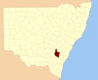
Bigga is a village in the Southern Tablelands of New South Wales, Australia, in Upper Lachlan Shire. It is in the Parish of Bigga, County of Georgiana. At the 2016 census, Bigga and the surrounding area had a population of 245. The name Bigga is thought to originate as a shortened version of the Biggs Grant. Bigga is on the western side of the Abercrombie Mountains. It is 91 km northwest of Goulburn and 52 km southeast of Cowra. Nearby towns are: Abercrombie River, Binda, Greenmantle, Grabine, Reids Flat, and Tuena. Nearby places are: Blanket Flat and Crooked Corner. These places were once towns.

Wellington County, New South Wales Cadastral in New South Wales, Australia

Wellington County is a county in New South Wales, Australia, which was one of the original Nineteen Counties. The town of Wellington is near the north-eastern edge. The Bell River is the boundary to the west, and the Cudgegong River to the north. It includes land on both sides of the Macquarie River.

Camden County, New South Wales Cadastral in New South Wales, Australia

Camden County was one of the original Nineteen Counties in New South Wales and is now one of the 141 Cadastral divisions of New South Wales. It included the coastal area near Wollongong south to the Shoalhaven River, and also inland encompassing Berrima and Picton. Its western boundary was the Wollondilly River. The first settlement in the area was Camden Park, established by John Macarthur in 1806, just across the Nepean River from Cumberland County. It was the first land across the Nepean to be settled. Camden is a present-day suburb of Sydney in the same area, although parts of it are in Cumberland.

St Vincent County Cadastral in Australian Capital Territory

St Vincent County was one of the original Nineteen Counties in New South Wales and is now one of the 141 Cadastral divisions of New South Wales. It included the south coast area encompassing Batemans Bay, Ulladulla, Jervis Bay and inland to Braidwood. The Shoalhaven River is the boundary to the north and west, and the Deua River the boundary to the south.

King County, New South Wales Cadastral in New South Wales, Australia

King County was one of the original Nineteen Counties in New South Wales and is now one of the 141 Cadastral divisions of New South Wales. It is in the area to the east of Yass. The northern part of it lies between the Lachlan River and the Boorowa River, including the locations of Frogmore, Taylors Flat, Gunnary, Rugby and Rye Park. The Crookwell River is also part of the northern boundary. The Yass River is the southern boundary.

Bathurst County Cadastral in New South Wales, Australia

Bathurst County was one of the original Nineteen Counties in New South Wales and is now one of the 141 Cadastral divisions of New South Wales. It includes the area to the south-west of Bathurst to Cowra and Orange. The Lachlan River is the boundary to the south-west, the Belubula River forms part of the northern boundary, with the Fish River on the northeastern boundary. Blayney is located roughly in the middle.

Brisbane County Cadastral in New South Wales, Australia

Brisbane County was one of the original Nineteen Counties in New South Wales and is now one of the 141 Cadastral divisions of New South Wales. It includes Scone, Merriwa and Murrurundi. The Goulburn River is the boundary to the south and the Hunter River the boundary to the south-east. The Liverpool Range area is the boundary to the north, and the Krui River the boundary to the west.

Bligh County Cadastral in New South Wales, Australia

Bligh County was one of the original Nineteen Counties in New South Wales and is now one of the 141 Cadastral divisions of New South Wales. The Cudgegong River and the Goulburn River are its southern boundaries; the Krui River is the eastern boundary, and the Burragundy River the northern boundary. It includes the villages of Cassilis and Dunedoo.

Buccleuch County Cadastral in New South Wales, Australia

Buccleuch County is one of the 141 Cadastral divisions of New South Wales. It contains the locality of Adjungbilly. The Murrumbidgee River is at the northern boundary, with the Goodradigbee River on the eastern boundary, and the Tumut River on the western boundary. It includes the northern part of the Kosciuszko National Park.

Waradgery County Cadastral in New South Wales, Australia

Waradgery County is one of the 141 Cadastral divisions of New South Wales. It contains the town of Hay. It includes the area between the Lachlan River and the Murrumbidgee River where they meet. The Lachlan River is the northern boundary of the county, and the Murrumbidgee for a small section is the southern boundary, but the county also includes some of the land to the south of the Murrumbidgee near Hay.

Clyde County Cadastral in New South Wales, Australia

Clyde County is one of the 141 Cadastral divisions of the Australian state of New South Wales. It is located between the Bogan River and Barwon River in the area between them where they join. This is the area to the south of Brewarrina, as far east as the Carinda area. A very small part of the Macquarie River and Castlereagh River is also part of the boundary in the north-east.

Cowper County Cadastral in New South Wales, Australia

Cowper County, New South Wales is one of the 141 Cadastral divisions of New South Wales.

Gunderbooka County Cadastral in New South Wales, Australia

Gunderbooka County is one of the 141 Cadastral divisions of New South Wales. The Warrego River is the western boundary, and the Culgoa River and Darling River is the south-eastern boundary. It includes the area down to where the Warrego meets the Darling, to the north of Bourke.

Parry County Cadastral in New South Wales, Australia

Parry County is one of the 141 Cadastral divisions of New South Wales. It is bounded by the Peel River and Cockburn River on the north, near Tamworth. The Moonbi Range is on the eastern boundary, and the Peel Range on the western boundary. The Great Dividing Range is the boundary to the south-east. It includes the towns of Dungowan, Woolomin, Piallamore and Nundle.

Wallace County, New South Wales Cadastral in New South Wales, Australia

Wallace County is one of the 141 Cadastral divisions of New South Wales. The Snowy River is the boundary to the south and south-east, and the Murrumbidgee River is the northern boundary. It includes the area around Jindabyne.

Wentworth County Cadastral in New South Wales, Australia

Wentworth County is one of the 141 Cadastral divisions of New South Wales. The Murray River is the boundary to the south, and the Anabranch of the Darling River is the western boundary. It includes the area where the Darling River joins the Murray River.

Young County, New South Wales Cadastral in New South Wales, Australia

Young County is one of the 141 Cadastral divisions of New South Wales. It includes the area to the west of Wilcannia. The Darling River is the south-eastern boundary.

Cobrabald River river in Australia

Cobrabald River, a mostly perennial river that is part of the Namoi catchment within the Murray–Darling basin, is located in the Northern Tablelands district of New South Wales, Australia.

The Coolumbooka River, a perennial river of the Snowy River catchment, is located in the Monaro region of New South Wales, Australia.

References

  1. "Georgiana County". Geographical Names Register (GNR) of NSW. Geographical Names Board of New South Wales. OOjs UI icon edit-ltr-progressive.svg