Tara New South Wales | |||||||||||||||
---|---|---|---|---|---|---|---|---|---|---|---|---|---|---|---|
Location in New South Wales | |||||||||||||||
|
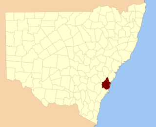
Tara County is one of the 141 Cadastral divisions of New South Wales. It is located in the south-western corner of the state, to the north of the Murray River, and to the east of the border with South Australia. The Darling Anabranch River is the eastern boundary. It includes the Tarawi Nature Reserve and the localities of Huntingfield, Pine Camp, Nulla, Warranangra and Rufus River, as well as Lake Victoria.
The Murray River is Australia's longest river, at 2,508 kilometres (1,558 mi) in length. The Murray rises in the Australian Alps, draining the western side of Australia's highest mountains, and then meanders across Australia's inland plains, forming the border between the states of New South Wales and Victoria as it flows to the northwest into South Australia. It turns south at Morgan for its final 315 kilometres (196 mi), reaching the ocean at Lake Alexandrina.
South Australia is a state in the southern central part of Australia. It covers some of the most arid parts of the country. With a total land area of 983,482 square kilometres (379,725 sq mi), it is the fourth-largest of Australia's states and territories by area, and fifth largest by population. It has a total of 1.7 million people, and its population is the second most highly centralised in Australia, after Western Australia, with more than 77 percent of South Australians living in the capital, Adelaide, or its environs. Other population centres in the state are relatively small; Mount Gambier, the second largest centre, has a population of 28,684.
Rufus River, a watercourse of the Murray catchment and part of the Murray-Darling basin, is located in the western Riverina region of south western New South Wales, Australia.
Tara is believed to be derived from a local Aboriginal word. [1]
Indigenous Australians are the Aboriginal and Torres Strait Islander peoples of Australia, descended from groups that existed in Australia and surrounding islands before British colonisation. The time of arrival of the first Indigenous peoples on the continent and nearby islands is a matter of debate among researchers. The earliest conclusively human remains found in Australia are those of Mungo Man LM3 and Mungo Lady, which have been dated to around 50,000 years BP. Recent archaeological evidence from the analysis of charcoal and artefacts revealing human use suggests a date as early as 65,000 BP. Luminescence dating has suggested habitation in Arnhem Land as far back as 60,000 years BP. Genetic research has inferred a date of habitation as early as 80,000 years BP. Other estimates have ranged up to 100,000 years and 125,000 years BP.
A full list of parishes found within this county; their current LGA and mapping coordinates to the approximate centre of each location is as follows:
Local government in Australia is the third tier of government in Australia administered by the states and territories, which in turn are beneath the federal tier. Local government is not mentioned in the Constitution of Australia and two referenda in the 1970s and 1980s to alter the Constitution relating to local government were unsuccessful. Every state government recognises local government in their respective constitutions. Unlike Canada or the United States, there is only one level of local government in each state, with no distinction such as cities and counties.
Tara may refer to:
The Yass River, a perennial river that is part of the Murrumbidgee catchment within the Murray–Darling basin, is located in the Southern Tablelands and South Western Slopes districts of New South Wales, Australia.
Darbalara is a rural community on the east bank of the junction of the Murrumbidgee River and Tumut River in the Riverina. It is situated by road, about 25 kilometres north east of Gundagai and 25 kilometres south of Coolac.
Gloucester County was one of the original Nineteen Counties in New South Wales, and is now one of the 141 cadastral divisions of New South Wales. It includes the area around Port Stephens. It is bounded on the north and west by the Manning River, and on the south-west by the Williams River.
Northumberland County was one of the original Nineteen Counties in New South Wales and is now one of the 141 Cadastral divisions of New South Wales. It included the area to the north of Broken Bay, including Lake Macquarie and Newcastle. It was bounded by the part of the Hawkesbury River to the south, the Macdonald River to the south-west, and the Hunter River to the north.
Camden County was one of the original Nineteen Counties in New South Wales and is now one of the 141 Cadastral divisions of New South Wales. It included the coastal area near Wollongong south to the Shoalhaven River, and also inland encompassing Berrima and Picton. Its western boundary was the Wollondilly River. The first settlement in the area was Camden Park, established by John Macarthur in 1806, just across the Nepean River from Cumberland County. It was the first land across the Nepean to be settled. Camden is a present-day suburb of Sydney in the same area, although parts of it are in Cumberland.
St Vincent County was one of the original Nineteen Counties in New South Wales and is now one of the 141 Cadastral divisions of New South Wales. It included the south coast area encompassing Batemans Bay, Ulladulla, Jervis Bay and inland to Braidwood. The Shoalhaven River is the boundary to the north and west, and the Deua River the boundary to the south.
Cowper County, New South Wales is one of the 141 Cadastral divisions of New South Wales.
Oxley County, New South Wales is one of the 141 Cadastral divisions of New South Wales. It is located between the Bogan River on the west, and the Macquarie River on the east. This is the area approximately between Warren and Nyngan.
The Moonie River is a river in Shire of Balonne, Queensland and Walgett Shire, New South Wales, both in Australia. It is a perennial river of the Barwon catchment within the Murray–Darling basin.
The Bemboka River, a perennial stream of the Bega River catchment, is located in the Monaro and South Coast regions of New South Wales, Australia.
Boorowa River, a perennial stream that is part of the Lachlan catchment within the Murray–Darling basin, is located in the central–western region of New South Wales, Australia.
Cobrabald River, a mostly perennial river that is part of the Namoi catchment within the Murray–Darling basin, is located in the Northern Tablelands district of New South Wales, Australia.
The Coolumbooka River, a perennial river of the Snowy River catchment, is located in the Monaro region of New South Wales, Australia.
The Kedumba River, a perennial river that is part of the Hawkesbury-Nepean catchment, is located in the Blue Mountains and Macarthur regions of New South Wales, Australia.
Little Murray River, an anabranch of the Murray River and part of the Murray-Darling basin, is located in the western Riverina region of south western New South Wales, Australia.
Bettowynd Creek, a partly perennial stream of the Moruya River catchment, is located in the Southern Tablelands and South Coast regions of New South Wales, Australia.
The Clouds Creek, a perennial stream that is part of the Clarence River catchment, is located in the Northern Tablelands region of New South Wales, Australia.