Townsend County

Last updated

Map all coordinates using: OpenStreetMap  
Download coordinates as: KML  ·  GPX
Townsend
New South Wales
Townsend NSW.PNG
Location in New South Wales
Lands administrative divisions around Townsend:
Waradgery Waradgery Boyd
Wakool Townsend Urana
Cadell Moira (Vic) Denison

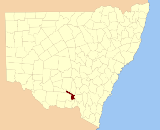
Townsend County is one of the 141 Cadastral divisions of New South Wales. It is in the south of New South Wales with the Murray River to the south. Deniliquin is located there.

Murray River the longest river in Australia

The Murray River is Australia's longest river, at 2,508 kilometres (1,558 mi) in length. The Murray rises in the Australian Alps, draining the western side of Australia's highest mountains, and then meanders across Australia's inland plains, forming the border between the states of New South Wales and Victoria as it flows to the northwest into South Australia. It turns south at Morgan for its final 315 kilometres (196 mi), reaching the ocean at Lake Alexandrina.

Deniliquin Town in New South Wales, Australia

Deniliquin, known locally as "Deni", is a town in the Riverina region of New South Wales close to the border with Victoria. It is the largest town in the Edward River Council local government area.

Townsend County was named in honour of the surveyor Thomas S Townsend who was an assistant surveyor to Thomas Livingstone Mitchell. [1]

Parishes within this county

A full list of parishes found within this county; their current LGA and mapping coordinates to the approximate centre of each location is as follows:

Local government in Australia third tier of government in Australia

Local government in Australia is the third tier of government in Australia administered by the states and territories, which in turn are beneath the federal tier. Local government is not mentioned in the Constitution of Australia and two referenda in the 1970s and 1980s to alter the Constitution relating to local government were unsuccessful. Every state government recognises local government in their respective constitutions. Unlike Canada or the United States, there is only one level of local government in each state, with no distinction such as cities and counties.

Banangalite Edward River Council 35°19′54″S144°38′04″E / 35.33167°S 144.63444°E / -35.33167; 144.63444 (Banangalite)
Barratta Edward River Council 35°13′54″S144°33′04″E / 35.23167°S 144.55111°E / -35.23167; 144.55111 (Barratta)
Belmore Edward River Council 35°13′54″S145°00′04″E / 35.23167°S 145.00111°E / -35.23167; 145.00111 (Belmore)
Billabong Edward River Council 35°06′54″S144°35′04″E / 35.11500°S 144.58444°E / -35.11500; 144.58444 (Billabong)
Bingellibunbi Edward River Council 35°01′54″S144°43′04″E / 35.03167°S 144.71778°E / -35.03167; 144.71778 (Bingellibunbi)
Birganbigil Edward River Council 35°30′54″S145°11′04″E / 35.51500°S 145.18444°E / -35.51500; 145.18444 (Birganbigil)
Blackwood Edward River Council 35°31′54″S145°23′04″E / 35.53167°S 145.38444°E / -35.53167; 145.38444 (Blackwood)
Booabula Edward River Council 35°08′54″S145°00′04″E / 35.14833°S 145.00111°E / -35.14833; 145.00111 (Booabula)
Boonoke Edward River Council 35°19′54″S145°03′04″E / 35.33167°S 145.05111°E / -35.33167; 145.05111 (Boonoke)
Boorga Murray River Council 35°41′54″S145°10′04″E / 35.69833°S 145.16778°E / -35.69833; 145.16778 (Boorga)
Booroorban Edward River Council 35°00′54″S144°45′04″E / 35.01500°S 144.75111°E / -35.01500; 144.75111 (Booroorban)
Boree Edward River Council 35°17′54″S144°48′04″E / 35.29833°S 144.80111°E / -35.29833; 144.80111 (Boree)
Bowna Edward River Council 34°51′54″S145°26′04″E / 34.86500°S 145.43444°E / -34.86500; 145.43444 (Bowna)
Boyeo Murray River Council 35°44′54″S144°53′04″E / 35.74833°S 144.88444°E / -35.74833; 144.88444 (Boyeo)
Brassi Murray River Council 35°30′54″S144°46′04″E / 35.51500°S 144.76778°E / -35.51500; 144.76778 (Brassi)
Bullatella Murray River Council 35°44′54″S145°00′04″E / 35.74833°S 145.00111°E / -35.74833; 145.00111 (Bullatella)
Bungooka Murray River Council 35°44′54″S145°09′04″E / 35.74833°S 145.15111°E / -35.74833; 145.15111 (Bungooka)
Campbell Edward River Council 35°04′54″S145°11′04″E / 35.08167°S 145.18444°E / -35.08167; 145.18444 (Campbell)
Carroonboon North Edward River Council 35°00′54″S144°37′04″E / 35.01500°S 144.61778°E / -35.01500; 144.61778 (Carroonboon North)
Carroonboon Edward River Council 35°01′54″S144°37′04″E / 35.03167°S 144.61778°E / -35.03167; 144.61778 (Carroonboon)
Carse Edward River Council 34°54′54″S145°27′04″E / 34.91500°S 145.45111°E / -34.91500; 145.45111 (Carse)
Citgathen Murray River Council 35°35′54″S144°49′04″E / 35.59833°S 144.81778°E / -35.59833; 144.81778 (Citgathen)
Colimo Murray River Council 35°28′54″S144°36′04″E / 35.48167°S 144.60111°E / -35.48167; 144.60111 (Colimo)
Conargo Edward River Council 35°19′54″S145°07′04″E / 35.33167°S 145.11778°E / -35.33167; 145.11778 (Conargo)
Coolagali Edward River Council 35°34′54″S145°05′04″E / 35.58167°S 145.08444°E / -35.58167; 145.08444 (Coolagali)
Coolambil Edward River Council 35°08′54″S145°04′04″E / 35.14833°S 145.06778°E / -35.14833; 145.06778 (Coolambil)
Cornalla Murray River Council 35°47′54″S145°03′04″E / 35.79833°S 145.05111°E / -35.79833; 145.05111 (Cornalla)
Cudoc Murray River Council 35°41′54″S144°47′04″E / 35.69833°S 144.78444°E / -35.69833; 144.78444 (Cudoc)
Currabunganung Edward River Council 35°23′54″S145°27′04″E / 35.39833°S 145.45111°E / -35.39833; 145.45111 (Currabunganung)
Dahwilly Edward River Council 35°25′54″S144°52′04″E / 35.43167°S 144.86778°E / -35.43167; 144.86778 (Dahwilly)
Derrulaman Murray River Council 35°37′54″S145°00′04″E / 35.63167°S 145.00111°E / -35.63167; 145.00111 (Derrulaman)
Devon Edward River Council 35°14′54″S144°42′04″E / 35.24833°S 144.70111°E / -35.24833; 144.70111 (Devon)
Drysdale Edward River Council 34°51′54″S144°44′04″E / 34.86500°S 144.73444°E / -34.86500; 144.73444 (Drysdale)
Dulverton Edward River Council 35°13′54″S144°49′04″E / 35.23167°S 144.81778°E / -35.23167; 144.81778 (Dulverton)
Dunkeld Edward River Council 35°01′54″S145°20′04″E / 35.03167°S 145.33444°E / -35.03167; 145.33444 (Dunkeld)
Edgar Edward River Council 35°01′54″S145°16′04″E / 35.03167°S 145.26778°E / -35.03167; 145.26778 (Edgar)
Euroka Edward River Council 35°07′54″S145°22′04″E / 35.13167°S 145.36778°E / -35.13167; 145.36778 (Euroka)
Euroley Edward River Council 34°52′54″S145°00′04″E / 34.88167°S 145.00111°E / -34.88167; 145.00111 (Euroley)
Finlay Edward River Council 35°03′54″S145°05′04″E / 35.06500°S 145.08444°E / -35.06500; 145.08444 (Finlay)
Gilbert Edward River Council 35°02′54″S145°00′04″E / 35.04833°S 145.00111°E / -35.04833; 145.00111 (Gilbert)
Gobram Murray River Council 35°31′54″S144°34′04″E / 35.53167°S 144.56778°E / -35.53167; 144.56778 (Gobram)
Gonawarra Edward River Council 35°05′54″S144°54′04″E / 35.09833°S 144.90111°E / -35.09833; 144.90111 (Gonawarra)
Gotha Murray River Council 35°35′54″S144°39′04″E / 35.59833°S 144.65111°E / -35.59833; 144.65111 (Gotha)
Harold Edward River Council 34°56′54″S145°06′04″E / 34.94833°S 145.10111°E / -34.94833; 145.10111 (Harold)
Hartwood Edward River Council 35°18′54″S145°28′04″E / 35.31500°S 145.46778°E / -35.31500; 145.46778 (Hartwood)
Hebden Edward River Council 35°08′54″S144°01′04″E / 35.14833°S 144.01778°E / -35.14833; 144.01778 (Hebden)
Jung Jung Edward River Council 34°59′54″S145°26′04″E / 34.99833°S 145.43444°E / -34.99833; 145.43444 (Jung Jung)
Kerranakoon Edward River Council 35°24′54″S144°46′04″E / 35.41500°S 144.76778°E / -35.41500; 144.76778 (Kerranakoon)
Lamb Edward River Council 35°05′54″S145°00′04″E / 35.09833°S 145.00111°E / -35.09833; 145.00111 (Lamb)
Loch Edward River Council 34°51′54″S145°22′04″E / 34.86500°S 145.36778°E / -34.86500; 145.36778 (Loch)
Mallee Edward River Council 35°12′54″S144°56′04″E / 35.21500°S 144.93444°E / -35.21500; 144.93444 (Mallee)
Monimail Edward River Council 35°20′54″S144°55′04″E / 35.34833°S 144.91778°E / -35.34833; 144.91778 (Monimail)
Moonbria Edward River Council 35°12′54″S145°21′04″E / 35.21500°S 145.35111°E / -35.21500; 145.35111 (Moonbria)
Morago Edward River Council 35°20′54″S144°38′04″E / 35.34833°S 144.63444°E / -35.34833; 144.63444 (Morago)
Morton Edward River Council 34°53′54″S145°32′04″E / 34.89833°S 145.53444°E / -34.89833; 145.53444 (Morton)
Moultrassie Edward River Council 34°56′54″S145°21′04″E / 34.94833°S 145.35111°E / -34.94833; 145.35111 (Moultrassie)
Mundiwa Edward River Council 35°31′04″S145°05′34″E / 35.51778°S 145.09278°E / -35.51778; 145.09278 (Mundiwa)
Myall Edward River Council 34°54′54″S144°37′04″E / 34.91500°S 144.61778°E / -34.91500; 144.61778 (Myall)
Nallam Murray River Council 35°48′54″S144°57′04″E / 35.81500°S 144.95111°E / -35.81500; 144.95111 (Nallam)
Nardoo Edward River Council 35°05′54″S145°30′04″E / 35.09833°S 145.50111°E / -35.09833; 145.50111 (Nardoo)
Narrama Edward River Council 35°31′54″S145°17′04″E / 35.53167°S 145.28444°E / -35.53167; 145.28444 (Narrama)
Narratoola Murray River Council 35°44′54″S145°18′04″E / 35.74833°S 145.30111°E / -35.74833; 145.30111 (Narratoola)
Neerim Edward River Council 35°09′54″S145°09′04″E / 35.16500°S 145.15111°E / -35.16500; 145.15111 (Neerim)
North Conargo Edward River Council 35°14′54″S145°08′04″E / 35.24833°S 145.13444°E / -35.24833; 145.13444 (North Conargo)
North Currabunganung Edward River Council 35°18′54″S145°21′04″E / 35.31500°S 145.35111°E / -35.31500; 145.35111 (North Currabunganung)
North Deniliquin Edward River Council 35°31′54″S145°00′04″E / 35.53167°S 145.00111°E / -35.53167; 145.00111 (North Deniliquin)
North Moonbria Edward River Council 35°02′54″S145°25′04″E / 35.04833°S 145.41778°E / -35.04833; 145.41778 (North Moonbria)
North Zara Edward River Council 35°05′54″S144°45′04″E / 35.09833°S 144.75111°E / -35.09833; 144.75111 (North Zara)
Nyangay Edward River Council 34°53′54″S144°49′04″E / 34.89833°S 144.81778°E / -34.89833; 144.81778 (Nyangay)
Officer Edward River Council 35°04′54″S144°42′04″E / 35.08167°S 144.70111°E / -35.08167; 144.70111 (Officer)
Palmer Edward River Council 34°52′54″S144°54′04″E / 34.88167°S 144.90111°E / -34.88167; 144.90111 (Palmer)
Peppin Edward River Council 35°13′54″S144°53′04″E / 35.23167°S 144.88444°E / -35.23167; 144.88444 (Peppin)
Powheep Edward River Council 34°54′54″S145°16′04″E / 34.91500°S 145.26778°E / -34.91500; 145.26778 (Powheep)
Puckawidgee Edward River Council 35°12′54″S145°14′04″E / 35.21500°S 145.23444°E / -35.21500; 145.23444 (Puckawidgee)
Pungulgui Edward River Council 35°39′54″S145°19′04″E / 35.66500°S 145.31778°E / -35.66500; 145.31778 (Pungulgui)
Purdanima Murray River Council 35°31′54″S144°41′04″E / 35.53167°S 144.68444°E / -35.53167; 144.68444 (Purdanima)
Quandong Edward River Council 34°51′54″S144°39′04″E / 34.86500°S 144.65111°E / -34.86500; 144.65111 (Quandong)
Quiamong Edward River Council 35°21′54″S145°14′04″E / 35.36500°S 145.23444°E / -35.36500; 145.23444 (Quiamong)
Ricketson Edward River Council 35°13′54″S144°39′04″E / 35.23167°S 144.65111°E / -35.23167; 144.65111 (Ricketson)
Ronald Edward River Council 34°56′54″S144°49′04″E / 34.94833°S 144.81778°E / -34.94833; 144.81778 (Ronald)
South Deniliquin Edward River Council 35°34′54″S144°56′04″E / 35.58167°S 144.93444°E / -35.58167; 144.93444 (South Deniliquin)
South Zara Edward River Council 35°11′54″S144°44′04″E / 35.19833°S 144.73444°E / -35.19833; 144.73444 (South Zara)
Stanaforth Edward River Council 35°11′54″S144°33′04″E / 35.19833°S 144.55111°E / -35.19833; 144.55111 (Stanaforth)
Tawarra Murray River Council 35°43′54″S145°14′04″E / 35.73167°S 145.23444°E / -35.73167; 145.23444 (Tawarra)
Tholobin Edward River Council 35°24′54″S145°06′04″E / 35.41500°S 145.10111°E / -35.41500; 145.10111 (Tholobin)
Thulabin Edward River Council 35°23′54″S145°18′04″E / 35.39833°S 145.30111°E / -35.39833; 145.30111 (Thulabin)
Thurgoon Edward River Council 35°36′54″S145°10′04″E / 35.61500°S 145.16778°E / -35.61500; 145.16778 (Thurgoon)
Towool Murray River Council 35°41′54″S145°03′04″E / 35.69833°S 145.05111°E / -35.69833; 145.05111 (Towool)
Tumudgery Murray River Council 35°25′54″S144°41′04″E / 35.43167°S 144.68444°E / -35.43167; 144.68444 (Tumudgery)
Walla Edward River Council 34°59′54″S145°33′04″E / 34.99833°S 145.55111°E / -34.99833; 145.55111 (Walla)
Wandook Edward River Council 35°26′54″S145°02′04″E / 35.44833°S 145.03444°E / -35.44833; 145.03444 (Wandook)
Wanganella Edward River Council 35°09′54″S144°50′04″E / 35.16500°S 144.83444°E / -35.16500; 144.83444 (Wanganella)
Warbreccan Murray River Council 35°30′54″S144°51′04″E / 35.51500°S 144.85111°E / -35.51500; 144.85111 (Warbreccan)
Wargam Edward River Council 35°00′54″S144°55′04″E / 35.01500°S 144.91778°E / -35.01500; 144.91778 (Wargam)
Warrawool Edward River Council 35°37′54″S145°15′04″E / 35.63167°S 145.25111°E / -35.63167; 145.25111 (Warrawool)
Warriston Edward River Council 35°08′54″S145°15′04″E / 35.14833°S 145.25111°E / -35.14833; 145.25111 (Warriston)
Warwillah Edward River Council 35°01′54″S144°54′04″E / 35.03167°S 144.90111°E / -35.03167; 144.90111 (Warwillah)
Werai Murray River Council 35°20′54″S144°32′04″E / 35.34833°S 144.53444°E / -35.34833; 144.53444 (Werai)
Werkenbergal Edward River Council 34°59′54″S145°00′04″E / 34.99833°S 145.00111°E / -34.99833; 145.00111 (Werkenbergal)
Willeroo Edward River Council 35°27′54″S145°11′04″E / 35.46500°S 145.18444°E / -35.46500; 145.18444 (Willeroo)
Willurah Edward River Council 34°59′54″S145°07′04″E / 34.99833°S 145.11778°E / -34.99833; 145.11778 (Willurah)
Winter Edward River Council 35°01′54″S144°48′04″E / 35.03167°S 144.80111°E / -35.03167; 144.80111 (Winter)
Wollamai Edward River Council 35°31′54″S145°27′04″E / 35.53167°S 145.45111°E / -35.53167; 145.45111 (Wollamai)
Wonnue Berrigan Shire 35°44′54″S145°23′04″E / 35.74833°S 145.38444°E / -35.74833; 145.38444 (Wonnue)
Wononga Edward River Council 35°13′54″S145°28′04″E / 35.23167°S 145.46778°E / -35.23167; 145.46778 (Wononga)
Woonox Edward River Council 35°26′54″S144°57′04″E / 35.44833°S 144.95111°E / -35.44833; 144.95111 (Woonox)
Wureep Edward River Council 34°52′54″S145°07′04″E / 34.88167°S 145.11778°E / -34.88167; 145.11778 (Wureep)
Yalama Murray River Council 35°39′54″S144°53′04″E / 35.66500°S 144.88444°E / -35.66500; 144.88444 (Yalama)
Yalgadoori Edward River Council 35°39′54″S145°24′04″E / 35.66500°S 145.40111°E / -35.66500; 145.40111 (Yalgadoori)
Yallakool Murray River Council 35°39′54″S144°30′04″E / 35.66500°S 144.50111°E / -35.66500; 144.50111 (Yallakool)
Yaloke Murray River Council 35°37′54″S144°44′04″E / 35.63167°S 144.73444°E / -35.63167; 144.73444 (Yaloke)

Related Research Articles

Mount Kosciuszko highest mountain in mainland Australia

Mount Kosciuszko is mainland Australia's highest mountain, at 2,228 metres (7,310 ft) above sea level. It is located on the Main Range of the Snowy Mountains in Kosciuszko National Park, part of the Australian Alps National Parks and Reserves, in New South Wales, Australia, and is located west of Crackenback and close to Jindabyne.

Thomas Mitchell (explorer) Scottish surveyor and explorer in Australia

Lieutenant Colonel Sir Thomas Livingstone Mitchell, surveyor and explorer of south-eastern Australia, was born at Grangemouth in Stirlingshire, Scotland. In 1827 he took up an appointment as Assistant Surveyor General of New South Wales. The following year he became Surveyor General and remained in this position until his death. Mitchell was knighted in 1839 for his contribution to the surveying of Australia.

The Geographical Names Board of New South Wales, a statutory authority of the Land and Property Information division, Department of Finance and Services in the Government of New South Wales, is the official body for naming and recording details of places and geographical names in the state of New South Wales, Australia.

Mount Townsend mountain in New South Wales, Australia

Mount Townsend, a mountain in the Main Range of the Great Dividing Range, is located in the Snowy Mountains region of New South Wales, Australia.

Mathoura Town in New South Wales, Australia

Mathoura is a small town in the Riverina region of southern New South Wales, Australia, in the Murray River Council local government area. At the 2016 census, Mathoura had a population of 938. The town's name is derived from an aboriginal word for 'windy'.

Argyle County Cadastral in New South Wales, Australia

Argyle County was one of the original Nineteen Counties in New South Wales and is now one of the 141 Cadastral divisions of New South Wales. It includes the area around Goulburn. It is bounded by Lake George in the south-west, the Shoalhaven River in the east, and the Wollondilly River in the north-east.

Mitchell County, New South Wales Cadastral in New South Wales, Australia

Mitchell County is one of the 141 Cadastral divisions of New South Wales. It contains the town of Collingullie. The Murrumbidgee River is the northern boundary.

Burnett County, New South Wales Cadastral in New South Wales, Australia

Burnett County, New South Wales is one of the 141 Cadastral divisions of New South Wales.

Finch County Cadastral in New South Wales, Australia

Finch County is one of the 141 Cadastral divisions of New South Wales. It is bounded by the Narran River in the west, the Barwon River to the south and east, and the Queensland border to the north. It includes Lightning Ridge.

Fitzgerald County Cadastral in New South Wales, Australia

Fitzgerald County is one of the 141 Cadastral divisions of New South Wales.

Gregory County, New South Wales Cadastral in New South Wales, Australia

Gregory County is one of the 141 Cadastral divisions of New South Wales. It is bordered by Bogan River in the west, and includes the area to the northeast of Nyngan. It includes the Macquarie Marshes Nature Reserve, and the town of Quambone.

Oxley County Cadastral in New South Wales, Australia

Oxley County, New South Wales is one of the 141 Cadastral divisions of New South Wales. It is located between the Bogan River on the west, and the Macquarie River on the east. This is the area approximately between Warren and Nyngan.

Perry County, New South Wales Cadastral in New South Wales, Australia

Perry County is one of the 141 Cadastral divisions of New South Wales. It is located to the east of the Darling River near Pooncarie.
White County, New South Wales Cadastral in New South Wales, Australia

White County is one of the 141 Cadastral divisions of New South Wales. It is located to the south of the Namoi River along both sides of Bohena Creek, with Narrabri at the northern end. It includes most of the Pilliga Nature Reserve.

Bendemeer, New South Wales Town in New South Wales, Australia

Bendemeer is a village of 485 people on the Macdonald River in the New England region of New South Wales, Australia. It is situated at the junction of the New England and Oxley Highways.

Dangarsleigh, New South Wales Town in New South Wales, Australia

Dangarsleigh is a rural locality and minor trigonometrical station about 11 km south east of Armidale, New South Wales. The locality is at an altitude of about 1,020 metres on the Northern Tablelands in the New England region of New South Wales, Australia. The name Dangarsleigh commemorates the surveyor and pastoralist Henry Dangar’s name. It is within the Armidale Regional Council local government area and Sandon County.

Moonie River river in Australia

The Moonie River is a river in Shire of Balonne, Queensland and Walgett Shire, New South Wales, both in Australia. It is a perennial river of the Barwon catchment within the Murray–Darling basin.

Francis Townsend Rusden was an Australian politician and pastoralist. He was a member of the New South Wales Legislative Assembly between 1856 and 1857 and again between 1860 and 1864.

St Georges Basin (New South Wales)

St Georges Basin is an open intermediate estuary, or inland sea, located in the South Coast region of New South Wales, adjacent to the Jervis Bay Territory.

James Charles Burnett Australian surveyor

James Charles Burnett (1815—1854) a.k.a. "John" was a surveyor and explorer in New South Wales, Australia. He was the head of the first Survey Office established at Brisbane in 1844.

References

  1. "Townsend". Geographical Names Register (GNR) of NSW. Geographical Names Board of New South Wales . Retrieved 4 August 2013. OOjs UI icon edit-ltr-progressive.svg