Dampier County

Last updated

Map all coordinates using: OpenStreetMap  
Download coordinates as: KML  ·  GPX
Dampier
New South Wales
Dampier NSW.PNG
Location in New South Wales
Lands administrative divisions around Dampier:
Murray St. Vincent Pacific Ocean
Beresford Dampier Pacific Ocean
Auckland Auckland Pacific Ocean

Dampier County is one of the 141 Cadastral divisions of New South Wales. The Deua River is the northern boundary, with land slightly to the north of the Brogo River the southern boundary. It includes Bermagui, Narooma, Bodalla, and most of the Deua National Park and Wadbilliga National Park.

Deua River

The Deua River, being the main perennial river of the Moruya River catchment, is located in the South Coast region of New South Wales, Australia.

Brogo River, a perennial river that is part of the Bega River catchment, is located in the South Coast region of New South Wales, Australia.

Bermagui, New South Wales Town in New South Wales, Australia

Bermagui is a town on the south coast of New South Wales, Australia in the Bega Valley Shire. The name is derived from the Dyirringanj word, permageua, possibly meaning 'canoe with paddles'.

Dampier County was named in honour of seaman William Dampier (1651-1715). [1]

William Dampier British scientist, pirate and explorer

William Dampier was an English explorer, ex-pirate and navigator who became the first Englishman to explore parts of what is today Australia, and the first person to circumnavigate the world three times. He has also been described as Australia's first natural historian, as well as one of the most important British explorers of the period between Sir Walter Raleigh and James Cook.

Parishes within this county

A full list of parishes found within this county; their current LGA and mapping coordinates to the approximate centre of each location is as follows:

Local government in Australia

Local government in Australia is the third tier of government in Australia administered by the states and territories, which in turn are beneath the federal tier. Local government is not mentioned in the Constitution of Australia and two referenda in the 1970s and 1980s to alter the Constitution relating to local government were unsuccessful. Every state government recognises local government in their respective constitutions. Unlike Canada or the United States, there is only one level of local government in each state, with no distinction such as cities and counties.

ParishLGACoordinates
Badja Eurobodalla Shire 36°03′54″S149°36′04″E / 36.06500°S 149.60111°E / -36.06500; 149.60111 (Badja Parish)
Belowra Eurobodalla Shire 36°08′54″S149°43′04″E / 36.14833°S 149.71778°E / -36.14833; 149.71778 (Belowra Parish)
Bergalia Eurobodalla Shire 35°58′54″S150°02′04″E / 35.98167°S 150.03444°E / -35.98167; 150.03444 (Bergalia Parish)
Bermagui Bega Valley Shire 36°24′54″S150°00′04″E / 36.41500°S 150.00111°E / -36.41500; 150.00111 (Bermagui Parish)
Bodalla Eurobodalla Shire 36°06′54″S150°04′04″E / 36.11500°S 150.06778°E / -36.11500; 150.06778 (Bodalla Parish)
Bumbo Eurobodalla Shire 36°03′54″S150°00′04″E / 36.06500°S 150.00111°E / -36.06500; 150.00111 (Bumbo Parish)
Bumbo West Eurobodalla Shire 36°00′54″S149°51′04″E / 36.01500°S 149.85111°E / -36.01500; 149.85111 (Bumbo West Parish)
Burra Eurobodalla Shire 35°53′54″S149°57′04″E / 35.89833°S 149.95111°E / -35.89833; 149.95111 (Burra Parish)
Cadgee Eurobodalla Shire 36°10′54″S149°51′04″E / 36.18167°S 149.85111°E / -36.18167; 149.85111 (Cadgee Parish)
Cadjangarry Bega Valley Shire 36°27′54″S149°56′04″E / 36.46500°S 149.93444°E / -36.46500; 149.93444 (Cadjangarry Parish)
Congo Eurobodalla Shire 35°58′54″S150°07′04″E / 35.98167°S 150.11778°E / -35.98167; 150.11778 (Congo Parish)
Coondella Eurobodalla Shire 35°57′54″S149°48′04″E / 35.96500°S 149.80111°E / -35.96500; 149.80111 (Coondella Parish)
Countegany Snowy Monaro Regional Council 36°18′54″S149°35′04″E / 36.31500°S 149.58444°E / -36.31500; 149.58444 (Countegany Parish)
Curmulee Eurobodalla Shire 35°49′54″S149°45′04″E / 35.83167°S 149.75111°E / -35.83167; 149.75111 (Curmulee Parish)
Currambene Queanbeyan-Palerang Regional Council 35°56′54″S149°34′04″E / 35.94833°S 149.56778°E / -35.94833; 149.56778 (Currambene Parish)
Deua Eurobodalla Shire 35°53′54″S149°49′04″E / 35.89833°S 149.81778°E / -35.89833; 149.81778 (Deua Parish)
Dolondundale Snowy Monaro Regional Council 36°18′54″S149°28′04″E / 36.31500°S 149.46778°E / -36.31500; 149.46778 (Dolondundale Parish)
Donovan Eurobodalla Shire 35°49′54″S149°56′04″E / 35.83167°S 149.93444°E / -35.83167; 149.93444 (Donovan Parish)
Eurobodalla Eurobodalla Shire 36°12′54″S149°55′04″E / 36.21500°S 149.91778°E / -36.21500; 149.91778 (Eurobodalla Parish)
Guinea Snowy Monaro Regional Council 36°11′54″S149°32′04″E / 36.19833°S 149.53444°E / -36.19833; 149.53444 (Guinea Parish)
Gulph Eurobodalla Shire 36°04′54″S149°51′04″E / 36.08167°S 149.85111°E / -36.08167; 149.85111 (Gulph Parish)
Jillaga Queanbeyan-Palerang Regional Council 36°00′54″S149°38′04″E / 36.01500°S 149.63444°E / -36.01500; 149.63444 (Jillaga Parish)
Jinden Snowy Monaro Regional Council 35°51′54″S149°33′04″E / 35.86500°S 149.55111°E / -35.86500; 149.55111 (Jinden Parish)
Merricumbene Eurobodalla Shire 35°45′54″S149°51′04″E / 35.76500°S 149.85111°E / -35.76500; 149.85111 (Merricumbene Parish)
Moruya Eurobodalla Shire 35°55′54″S150°06′04″E / 35.93167°S 150.10111°E / -35.93167; 150.10111 (Moruya Parish)
Murrabrine Bega Valley Shire 36°25′54″S149°49′04″E / 36.43167°S 149.81778°E / -36.43167; 149.81778 (Murrabrine Parish)
Murrah Bega Valley Shire 36°31′54″S150°00′04″E / 36.53167°S 150.00111°E / -36.53167; 150.00111 (Murrah Parish)
Narira Bega Valley Shire 36°23′54″S149°54′04″E / 36.39833°S 149.90111°E / -36.39833; 149.90111 (Narira Parish)
Narooma Eurobodalla Shire 36°14′54″S150°04′04″E / 36.24833°S 150.06778°E / -36.24833; 150.06778 (Narooma Parish)
Nerrigundah Eurobodalla Shire 36°06′54″S150°00′04″E / 36.11500°S 150.00111°E / -36.11500; 150.00111 (Nerrigundah Parish)
Shoalhaven Queanbeyan-Palerang Regional Council 35°55′54″S149°38′04″E / 35.93167°S 149.63444°E / -35.93167; 149.63444 (Shoalhaven Parish)
Tanja Bega Valley Shire 36°35′54″S150°00′04″E / 36.59833°S 150.00111°E / -36.59833; 150.00111 (Tanja Parish)
Uranbene Eurobodalla Shire 35°58′54″S149°43′04″E / 35.98167°S 149.71778°E / -35.98167; 149.71778 (Uranbene Parish)
Wadbilliga Bega Valley Shire 36°11′54″S149°36′04″E / 36.19833°S 149.60111°E / -36.19833; 149.60111 (Wadbilliga Parish)
Wadbilliga West Bega Valley Shire 36°14′09″S149°35′27″E / 36.23583°S 149.59083°E / -36.23583; 149.59083 (Wadbilliga West Parish)
Wagonga Eurobodalla Shire 36°11′54″S150°05′04″E / 36.19833°S 150.08444°E / -36.19833; 150.08444 (Wagonga Parish)
Wamban Eurobodalla Shire 35°57′54″S149°57′04″E / 35.96500°S 149.95111°E / -35.96500; 149.95111 (Wamban Parish)
Wandella Bega Valley Shire 36°17′54″S149°52′04″E / 36.29833°S 149.86778°E / -36.29833; 149.86778 (Wandella Parish)
Wapengo Bega Valley Shire 36°33′54″S149°55′04″E / 36.56500°S 149.91778°E / -36.56500; 149.91778 (Wapengo Parish)
Wyanbene Eurobodalla Shire 35°46′54″S149°44′04″E / 35.78167°S 149.73444°E / -35.78167; 149.73444 (Wyanbene Parish)
Yowrie Bega Valley Shire 36°19′54″S149°45′04″E / 36.33167°S 149.75111°E / -36.33167; 149.75111 (Yowrie Parish)

Related Research Articles

Deua National Park Protected area in New South Wales, Australia

Deua is a national park located in New South Wales, Australia, 320 kilometres (200 mi) south of Sydney, and 100 kilometres (62 mi) east of Canberra. The nearest towns on the coast are Batemans Bay, Moruya and Narooma.

Moruya River

The Moruya River is an open and trained mature wave dominated barrier estuary or tidal river is located in the South Coast region of New South Wales, Australia. In its upper freshwater reaches, the river is known as the Deua River.

St Vincent County Cadastral in Australian Capital Territory

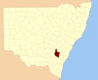
St Vincent County was one of the original Nineteen Counties in New South Wales and is now one of the 141 Cadastral divisions of New South Wales. It included the south coast area encompassing Batemans Bay, Ulladulla, Jervis Bay and inland to Braidwood. The Shoalhaven River is the boundary to the north and west, and the Deua River the boundary to the south.

King County, New South Wales Cadastral in New South Wales, Australia

King County was one of the original Nineteen Counties in New South Wales and is now one of the 141 Cadastral divisions of New South Wales. It is in the area to the east of Yass. The northern part of it lies between the Lachlan River and the Boorowa River, including the locations of Frogmore, Taylors Flat, Gunnary, Rugby and Rye Park. The Crookwell River is also part of the northern boundary. The Yass River is the southern boundary.

Buccleuch County Cadastral in New South Wales, Australia

Buccleuch County is one of the 141 Cadastral divisions of New South Wales. It contains the locality of Adjungbilly. The Murrumbidgee River is at the northern boundary, with the Goodradigbee River on the eastern boundary, and the Tumut River on the western boundary. It includes the northern part of the Kosciuszko National Park.

Ashburnham County Cadastral in New South Wales, Australia

Ashburnham County, New South Wales is one of the 141 Cadastral divisions of New South Wales. The Lachlan River and Belubula River is the southern boundary. It includes Parkes and Forbes.

<i>Eucalyptus stenostoma</i> species of plant

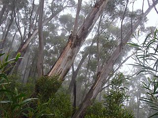
Eucalyptus stenostoma, the Jillaga ash, is a rarely seen eucalyptus tree in New South Wales in Australia. It grows in remote forests on the tablelands of south eastern New South Wales.

Buckenbowra River, a perennial river of the Clyde River catchment, is located in the upper ranges of the South Coast region of New South Wales, Australia.

Big Badja Hill mountain in Australia

Big Badja Hill, or Big Badga Mountain, a mountain on the Great Dividing Range, is located in the Southern Tablelands region of New South Wales, Australia, 47 kilometres (29 mi) north-east of Cooma. With an elevation of 1,363 metres (4,472 ft) above sea level, the mountain is situated on the western edge of Deua National Park.

<i>Eucalyptus wilcoxii</i> species of plant

Eucalyptus wilcoxii, the Deua Gum is mountain eucalyptus of south eastern Australia. Usually a multi-stemmed mallee or small tree reaching 15 metres in height.

The Little River, a perennial river that is part of the Hawkesbury-Nepean catchment, is located in the Central Tablelands region of New South Wales, Australia.

Araluen Creek, a partly perennial stream of the Moruya River catchment, is located in the Southern Tablelands and South Coast regions of New South Wales, Australia.

Bettowynd Creek, a partly perennial stream of the Moruya River catchment, is located in the Southern Tablelands and South Coast regions of New South Wales, Australia.

The Boundary Creek, a perennial stream of the Clarence River catchment, is located in the Northern Rivers region of New South Wales, Australia.

Scout Creek river in Australia

Scout Creek is an urban gully, is located in Hornsby Shire local government area of Sydney, New South Wales, Australia. It is part of the Parramatta River catchment.

Berlang Town in New South Wales, Australia

Berlang is a locality in Queanbeyan-Palerang Regional Council, New South Wales, Australia. It was previously called Tallaganda. The town lies about 44km south of Braidwood on the upper Shoalhaven River and the road to Cooma. At the 2016 census, it had a population of none. It includes part of the Deua National Park and the Berlang State Conservation Area. The Big Hole is a notable geological feature in the locality and the Deua National Park.

Merricumbene Town in New South Wales, Australia

Merricumbene is a locality in the Eurobodalla Shire, New South Wales, Australia. It is located about 43 km south of Braidwood and 40 km northwest of Moruya in the valley of the Deua River. At the 2016 census, it had a population of 19. It had a "half-time" school from 1893 to 1904.

Deua River Valley Town in New South Wales, Australia

Deua River Valley is a locality in the Eurobodalla Shire, New South Wales, Australia. It is located about 20 km northwest of Moruya on the road to Araluen in the valley of the Deua River. At the 2016 census, it had a population of 76. Much of its territory lies in the Deua National Park.

Kiora Town in New South Wales, Australia

Kiora is a locality in the Eurobodalla Shire, New South Wales, Australia. It is located about 11 km west of Moruya on the road to Araluen at the point where the Deua River becomes estuarine and changes its name to the Moruya River. At the 2016 census, it had a population of 54. Its name derives from "Kiora House", which belonged to John Hawdon. It had a public school from 1868 to 1928.

References

  1. "Dampier". Geographical Names Register (GNR) of NSW. Geographical Names Board of New South Wales . Retrieved 4 August 2013. OOjs UI icon edit-ltr-progressive.svg