Bridal Veil Falls, Bridalveil Falls or Bridalveil Fall is a frequently-used name for waterfalls that observers fancy resemble a bride's veil:

Interstate 24 (I-24) is an Interstate Highway in the Midwestern and Southeastern United States. It runs diagonally from I-57, 10 miles (16 km) south of Marion, Illinois, to Chattanooga, Tennessee, at I-75. It travels through Illinois, Kentucky, Tennessee, and Georgia. As an even-numbered Interstate, it is signed as an east–west route, though the route follows a more southeast–northwest routing, passing through Nashville, Tennessee. The numbering deviates from the standard Interstate Highway System grid, lying further north than its number would indicate west of Nashville.

Monteagle is a town in Franklin, Grundy, and Marion counties in the U.S. state of Tennessee, in the Cumberland Plateau region of the southeastern part of the state. The population was 1,238 at the 2000 census – 804 of the town's 1,238 residents (64.9%) lived in Grundy County, 428 (34.6%) in Marion County, and 6 (0.5%) in Franklin County. The population at the 2020 census was 1,393.

Hastings County is located in the province of Ontario, Canada. Geographically, it is located on the border of Eastern Ontario and Central Ontario. Hastings County is the second-largest county in Ontario, after Renfrew County, and its county seat is Belleville, which is independent of Hastings County. Hastings County has trademarked the moniker "Cheese Capital of Canada".

Thomas Spring Rice, 1st Baron Monteagle of Brandon, was a British Whig politician, who served as Chancellor of the Exchequer from 1835 to 1839.

Marquess of Sligo is a title in the Peerage of Ireland. It was created in 1800 for John Browne, 3rd Earl of Altamont. The Marquess holds the subsidiary titles of Baron Mount Eagle, of Westport in the County of Mayo, Viscount Westport, of Westport in the County of Mayo, Earl of Altamont, in the County of Mayo, Earl of Clanricarde and Baron Monteagle, of Westport in the County of Mayo. All these titles are in the Peerage of Ireland, except the Barony of Monteagle, which is in the Peerage of the United Kingdom. The latter peerage entitled the Marquesses to a seat in the House of Lords prior to the House of Lords Act 1999. The Earldom of Clanricarde was inherited by the sixth Marquess in 1916 according to a special remainder in the letters patent.
Baron Monteagle of Brandon, in the County of Kerry, is a title in the Peerage of the United Kingdom. Before his final exile, James II had intended the title to be conferred upon one of his supporters, Stephen Rice in the Jacobite peerage. Instead, it was created in 1839 in the reign of Queen Victoria for the Whig politician Thomas Spring Rice, a descendant of Stephen Rice. He served as Chancellor of the Exchequer between 1835 and 1839. He was succeeded by his grandson, the second Baron, his eldest son the Hon. Stephen Edmund Spring Rice having predeceased him. The second Lord Monteagle was a unionist politician and was made a Knight of the Order of St Patrick in 1885. On his death, the title passed to his son, the third Baron. He held minor diplomatic office. He was succeeded by his uncle, the fourth Baron. He was the younger son of the aforementioned the Hon. Stephen Edmund Spring Rice, eldest son of the first Baron. As of 2017 the title is held by the fourth Baron's great-grandson, the seventh Baron, who succeeded his father in 2013.

The York River is a river in Renfrew County, Hastings County and Haliburton County in Ontario, Canada. The river is in the Saint Lawrence River drainage basin, and flows from the southern extension of Algonquin Provincial Park to the Madawaska River.
The Geographical Names Board of New South Wales, a statutory authority of the Department of Customer Service in the Government of New South Wales, is the official body for naming and recording details of places and geographical names in the state of New South Wales, Australia.

Young Shire was a local government area in the South West Slopes region of New South Wales, Australia. The Shire was located adjacent to the Olympic Highway.

Darbalara is a rural community on the east bank of the junction of the Murrumbidgee River and Tumut River in the Riverina. It is situated by road, about 25 kilometres north east of Gundagai and 25 kilometres south of Coolac.

Cowper County, New South Wales is one of the 141 Cadastral divisions of New South Wales.
Icebreaker Glacier is a large valley glacier 10 miles (16 km) northeast of Mount Monteagle that flows southeast from the Mountaineer Range to Lady Newnes Bay, Victoria Land, Antarctica. Below Hermes Point its flow coalesces with that of Fitzgerald Glacier. The glacier was named by the New Zealand Geological Survey Antarctic Expedition, 1958–59, as a tribute to the work of the complements of U.S. Navy, and U.S. Coast Guard icebreakers in Antarctic exploration, in supporting scientists and in aiding other ships.
Finley Glacier is a tributary glacier which drains the northwest slopes of Mount Monteagle and flows north into the upper part of Icebreaker Glacier, in the Mountaineer Range, Victoria Land, Antarctica. It was mapped by the United States Geological Survey from surveys and U.S. Navy air photos, 1960–64, and was named by the Advisory Committee on Antarctic Names for Russell H. Finley, an aviation boatswain's mate with Squadron VX-6 during U.S. Navy Operation Deep Freeze, 1966, 1967 and 1968.
Mount Trenchard House is an Irish stately home located near Foynes, County Limerick, overlooking the River Shannon. It was the ancestral seat of the Rice, and subsequently Spring Rice, family.
The Bulla Creek, a mostly–perennial river that is part of the Lachlan sub-catchment of the Murrumbidgee catchment within the Murray–Darling basin, is located in the South West Slopes region of New South Wales, Australia. The Bulla Creek is only connected to the Murray Darling basin when the Bland Creek and both the Lachlan and Murrumbidgee Rivers are in flood.
Frogmore is a village in the Southern Tablelands of New South Wales, Australia. It was previously a mining town.

Hilltops Council is a local government area in the South West Slopes region of New South Wales, Australia. This area was formed on 12 May 2016 from the merger of Boorowa Council, Harden Shire and Young Shire. The local government area covers much the same area as the Hilltops wine region.

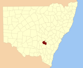
Monteagle is a locality in the South West Slopes region of New South Wales, Australia. The locality is in the Hilltops Council local government area, 366 kilometres (227 mi) south west of the state capital, Sydney.