Forbes County

Last updated

Forbes
New South Wales
Forbes NSW.PNG
Location in New South Wales
Lands administrative divisions around Forbes:
Cunningham Ashburnham Bathurst
Gipps Forbes Bathurst
Bland Monteagle King

Forbes County is one of the 141 cadastral divisions of New South Wales.

Forbes County was named in honour of Chief Justice Sir Francis Forbes (1784–1841). [1] It is located south of the Lachlan River near Forbes, down to Grenfell. It includes the area along the Lachlan east to Cowra and the Boorowa River, and also south to Koorawatha

The Lachlan River at Cowra; the river is the boundary between Forbes and Bathurst LachlanAtCowra.JPG
The Lachlan River at Cowra; the river is the boundary between Forbes and Bathurst

Parishes within this county

A full list of parishes found within this county; their current LGA and mapping coordinates to the approximate centre of each location is as follows:

ParishLGACoordinates
Bandon Forbes Shire 33°31′54″S148°15′04″E / 33.53167°S 148.25111°E / -33.53167; 148.25111 (Bandon)
Bang Bang Cowra Shire 34°01′54″S148°38′04″E / 34.03167°S 148.63444°E / -34.03167; 148.63444 (Bang Bang)
Binda Weddin Shire 33°38′54″S148°23′04″E / 33.64833°S 148.38444°E / -33.64833; 148.38444 (Binda)
Birangan Weddin Shire 33°42′54″S148°07′04″E / 33.71500°S 148.11778°E / -33.71500; 148.11778 (Birangan)
Bogolong Weddin Shire 33°48′54″S148°05′04″E / 33.81500°S 148.08444°E / -33.81500; 148.08444 (Bogolong)
Boyd Forbes Shire 33°54′54″S147°36′04″E / 33.91500°S 147.60111°E / -33.91500; 147.60111 (Boyd)
Braulin Forbes Shire 33°30′54″S148°01′04″E / 33.51500°S 148.01778°E / -33.51500; 148.01778 (Braulin)
Broula Cowra Shire 33°50′54″S148°33′04″E / 33.84833°S 148.55111°E / -33.84833; 148.55111 (Broula)
Bundaburrah Forbes Shire 33°30′54″S147°53′04″E / 33.51500°S 147.88444°E / -33.51500; 147.88444 (Bundaburrah)
Conimbla Cowra Shire 33°46′54″S148°31′04″E / 33.78167°S 148.51778°E / -33.78167; 148.51778 (Conimbla)
Cudgelong Cowra Shire 33°54′54″S148°46′04″E / 33.91500°S 148.76778°E / -33.91500; 148.76778 (Cudgelong)
Cumbijowa Forbes Shire 33°25′54″S148°08′04″E / 33.43167°S 148.13444°E / -33.43167; 148.13444 (Cumbijowa)
Currowong Forbes Shire 33°40′54″S147°50′04″E / 33.68167°S 147.83444°E / -33.68167; 147.83444 (Currowong)
Erasa Forbes Shire 33°15′54″S148°12′04″E / 33.26500°S 148.20111°E / -33.26500; 148.20111 (Erasa)
Eualdrie Weddin Shire 33°53′54″S148°03′04″E / 33.89833°S 148.05111°E / -33.89833; 148.05111 (Eualdrie)
Gooloogong Cowra Shire 33°39′54″S148°31′04″E / 33.66500°S 148.51778°E / -33.66500; 148.51778 (Gooloogong)
Goonigal Forbes Shire 33°37′54″S148°17′04″E / 33.63167°S 148.28444°E / -33.63167; 148.28444 (Goonigal)
Jemalong Forbes Shire 33°26′54″S147°48′04″E / 33.44833°S 147.80111°E / -33.44833; 147.80111 (Jemalong)
Kangarooby Weddin Shire 33°42′54″S148°20′04″E / 33.71500°S 148.33444°E / -33.71500; 148.33444 (Kangarooby)
Maudry Forbes Shire 33°41′54″S148°03′04″E / 33.69833°S 148.05111°E / -33.69833; 148.05111 (Maudry)
Melyra Weddin Shire 33°48′54″S148°11′04″E / 33.81500°S 148.18444°E / -33.81500; 148.18444 (Melyra)
Merriganowry Cowra Shire 33°44′54″S148°32′04″E / 33.74833°S 148.53444°E / -33.74833; 148.53444 (Merriganowry)
Morongla Cowra Shire 33°53′54″S148°39′04″E / 33.89833°S 148.65111°E / -33.89833; 148.65111 (Morongla)
Mulyan Cowra Shire 33°48′54″S148°35′04″E / 33.81500°S 148.58444°E / -33.81500; 148.58444 (Mulyan)
Mulyandry Forbes Shire 33°31′54″S148°07′04″E / 33.53167°S 148.11778°E / -33.53167; 148.11778 (Mulyandry)
Nanima Forbes Shire 33°31′54″S148°20′04″E / 33.53167°S 148.33444°E / -33.53167; 148.33444 (Nanima)
Neila Cowra Shire 34°01′54″S148°43′04″E / 34.03167°S 148.71778°E / -34.03167; 148.71778 (Neila)
Ooma Forbes Shire 33°38′54″S148°09′04″E / 33.64833°S 148.15111°E / -33.64833; 148.15111 (Ooma)
Tallabung Forbes Shire 33°33′54″S147°49′04″E / 33.56500°S 147.81778°E / -33.56500; 147.81778 (Tallabung)
Thurungle Forbes Shire 33°35′54″S148°02′04″E / 33.59833°S 148.03444°E / -33.59833; 148.03444 (Thurungle)
Waayourigong Forbes Shire 33°25′54″S147°54′04″E / 33.43167°S 147.90111°E / -33.43167; 147.90111 (Waayourigong)
Wallah Wallah Weddin Shire 33°44′54″S148°15′04″E / 33.74833°S 148.25111°E / -33.74833; 148.25111 (Wallah Wallah)
Warraderry Weddin Shire 33°41′54″S148°13′04″E / 33.69833°S 148.21778°E / -33.69833; 148.21778 (Warraderry)
Warrangong Cowra Shire 33°59′54″S148°30′04″E / 33.99833°S 148.50111°E / -33.99833; 148.50111 (Warrangong)
Warrumba Cowra Shire 33°48′54″S148°22′04″E / 33.81500°S 148.36778°E / -33.81500; 148.36778 (Warrumba)
Wattamondara Cowra Shire 33°54′54″S148°37′04″E / 33.91500°S 148.61778°E / -33.91500; 148.61778 (Wattamondara)
Wheoga Weddin Shire 33°45′54″S147°56′04″E / 33.76500°S 147.93444°E / -33.76500; 147.93444 (Wheoga)
Wongajong Forbes Shire 33°25′54″S148°02′04″E / 33.43167°S 148.03444°E / -33.43167; 148.03444 (Wongajong)

Related Research Articles

<span class="mw-page-title-main">Lands administrative divisions of New South Wales</span>

For lands administration purposes, New South Wales is divided into 141 counties, which are further divided into parishes. The counties were first set down in the Colony of New South Wales, which later became the Australian state of New South Wales. Note that counties should not be confused with county councils, which are local governments whose territories are known as county districts; the county councils and county districts usually have distinct names from the counties, and even on those rare occasions when they share the name with a county, they are legally distinct and cover non-identical territories.

<span class="mw-page-title-main">Gloucester County, New South Wales</span> Cadastral in New South Wales, Australia

Gloucester County was one of the original Nineteen Counties in New South Wales, and is now one of the 141 cadastral divisions of New South Wales. It includes the area around Port Stephens. It is bounded on the north and west by the Manning River, and on the south-west by the Williams River.

<span class="mw-page-title-main">Camden County, New South Wales</span> Cadastral in New South Wales, Australia

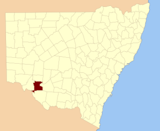
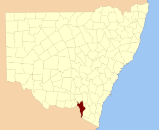
Camden County was one of the original Nineteen Counties in New South Wales and is now one of the 141 cadastral divisions of New South Wales. It included the coastal area near Wollongong south to the Shoalhaven River, and also inland encompassing Berrima and Picton. Its western boundary was the Wollondilly River. The first settlement in the area was Camden Park, established by John Macarthur in 1806, just across the Nepean River from Cumberland County. It was the first land across the Nepean to be settled. Camden is a present-day suburb of Sydney in the same area, although parts of it are in Cumberland.

<span class="mw-page-title-main">Georgiana County</span> Cadastral in New South Wales, Australia

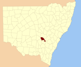
Georgiana County was one of the original Nineteen Counties in New South Wales and is now one of the 141 cadastral divisions of New South Wales. It lies in the area about halfway between Bathurst and Goulburn. The Lachlan River is the western boundary, with the Crookwell River the southern boundary. It includes Bigga, and the area surrounding the Abercrombie River. It was part of the Electoral district of King and Georgiana from 1856 to 1859.

<span class="mw-page-title-main">King County, New South Wales</span> Cadastral in New South Wales, Australia

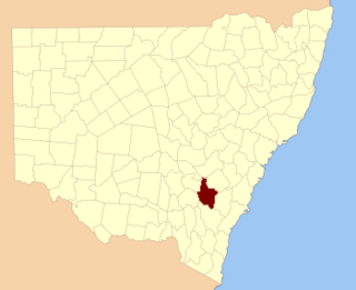
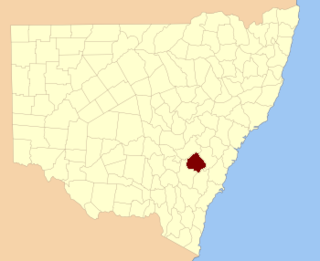
King County was one of the original Nineteen Counties in New South Wales and is now one of the 141 cadastral divisions of New South Wales. It is in the area to the east of Yass. The northern part of it lies between the Lachlan River and the Boorowa River, including the locations of Frogmore, Taylors Flat, Gunnary, Rugby and Rye Park. The Crookwell River is also part of the northern boundary. The Yass River is the southern boundary.

<span class="mw-page-title-main">Roxburgh County</span> Cadastral in New South Wales, Australia

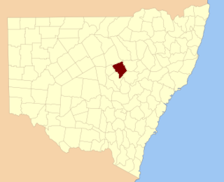
Roxburgh County was one of the original Nineteen Counties in New South Wales and is now one of the 141 cadastral divisions of New South Wales. It includes the area to the north east of Bathurst, lying to the north and east of the Fish River to the junction of the Turon River. It includes Sofala. The Gudgegong River is the border to the north.

<span class="mw-page-title-main">Bathurst County</span> Cadastral in New South Wales, Australia

Bathurst County was one of the original Nineteen Counties in New South Wales and is now one of the 141 cadastral divisions of New South Wales. It includes the area to the south-west of Bathurst to Cowra and Orange. The Lachlan River is the boundary to the south-west, the Belubula River forms part of the northern boundary, with the Fish River on the northeastern boundary. Blayney is located roughly in the middle.

<span class="mw-page-title-main">Caira County</span> Cadastral in New South Wales, Australia

Caira County is one of the 141 cadastral divisions of New South Wales. It contains the city of Balranald. It is located between where the Murrumbidgee River joins the Murray River to where the Lachlan River joins the Murrumbidgee, containing much of the western Lowbidgee Floodplain. The name "Caira" is believed to derive from a local Aboriginal word.

<span class="mw-page-title-main">Waljeers County</span> Cadastral in New South Wales, Australia

Waljeers County is one of the 141 cadastral divisions of New South Wales. It contains the town of Booligal.

<span class="mw-page-title-main">Waradgery County</span> Cadastral in New South Wales, Australia

Waradgery County is one of the 141 cadastral divisions of New South Wales. It contains the town of Hay. It includes the area between the Lachlan River and the Murrumbidgee River where they meet. The Lachlan River is the northern boundary of the county, and the Murrumbidgee for a small section is the southern boundary, but the county also includes some of the land to the south of the Murrumbidgee near Hay.

<span class="mw-page-title-main">Nicholson County</span> Cadastral in New South Wales, Australia

Nicholson County is one of the 141 cadastral divisions of New South Wales. It contains the towns of Hillston, Goolgowi, Gunbar, Merriwagga, Goorawin and Langtree. The Lachlan River is its north-western boundary.

<span class="mw-page-title-main">Ashburnham County</span> Cadastral in New South Wales, Australia

Ashburnham County, New South Wales is one of the 141 cadastral divisions of New South Wales. The Lachlan River and Belubula River is the southern boundary. It includes Parkes and Forbes.

<span class="mw-page-title-main">Blaxland County</span> Cadastral in New South Wales, Australia

Blaxland County is one of the 141 cadastral divisions of New South Wales. It is bounded to the south by the Lachlan River and a small part of Waverley Creek. It includes Mount Hope and the Nombinnie Nature Reserve.

<span class="mw-page-title-main">Cunningham County</span> Cadastral in New South Wales, Australia

Cunningham County is one of the 141 cadastral divisions of New South Wales. It is located to the north of the Lachlan River near Condobolin.

<span class="mw-page-title-main">Ewenmar County</span> Cadastral in New South Wales, Australia

Ewenmar County is one of the 141 cadastral divisions of New South Wales. It is located between the Macquarie River on the west and the Castlereagh River on the east, between Warren and Gilgandra. The name derives from a local Aboriginal word.

<span class="mw-page-title-main">Franklin County, New South Wales</span> Cadastral in New South Wales, Australia

Franklin County is one of the 141 cadastral divisions of New South Wales. It lies between Waverley Creek and the Lachlan River, in the area to the north-west of Hillston.

<span class="mw-page-title-main">Macquarie County</span> Cadastral in New South Wales, Australia

Macquarie County is one of the 141 cadastral divisions of New South Wales, Australia. It is bordered to the north by the Apsley River, and to the south by the Manning River. It includes Port Macquarie and the area around it.

<span class="mw-page-title-main">Oxley County</span> Cadastral in New South Wales, Australia

Oxley County, New South Wales is one of the 141 cadastral divisions of New South Wales. It is located between the Bogan River on the west, and the Macquarie River on the east. This is the area approximately between Warren and Nyngan.

<span class="mw-page-title-main">Selwyn County, New South Wales</span> Cadastral in New South Wales, Australia

Selwyn County is one of the 141 cadastral divisions of New South Wales. It is located to the east of the Murray River, with part of the Tumut River as its boundary to the north-east. It includes Mount Kosciuszko, the highest mountain in Australia.

Escort Way is a 114-kilometre (71 mi) country road in New South Wales running from Mitchell Highway in Orange to Lachlan Valley Way in Forbes. The name derives from the notorious hold up of the Lachlan Gold Escort by bushrangers in 1862 which occurred along the route, and subsequent lobbying by the Canowindra Historical Society to recognise this. Escort Rock, a heritage-listed geological formation is located adjacent to the road near Eugowra.

References

  1. "Forbes County". Geographical Names Register (GNR) of NSW. Geographical Names Board of New South Wales. OOjs UI icon edit-ltr-progressive.svg