King County, New South Wales

Last updated

Map all coordinates using: OpenStreetMap  
Download coordinates as: KML  ·  GPX
King
New South Wales
King NSW.PNG
Location in New South Wales
Lands administrative divisions around King:
Forbes Bathurst Georgiana
Monteagle King Argyle
Harden Murray Argyle

King County was one of the original Nineteen Counties in New South Wales and is now one of the 141 cadastral divisions of New South Wales. It is in the area to the east of Yass. The northern part of it lies between the Lachlan River and the Boorowa River, including the locations of Frogmore, Taylors Flat, Gunnary, Rugby and Rye Park. The Crookwell River is also part of the northern boundary. The Yass River is the southern boundary.

King County was named in honour of Governor Philip Gidley King (1758-1808). [1]

Parishes within this county

A full list of parishes found within this county; their current LGA and mapping coordinates to the approximate centre of each location is as follows:

ParishLGACoordinates
Alton Boorowa Council 34°13′54″S148°51′04″E / 34.23167°S 148.85111°E / -34.23167; 148.85111 (Alton Parish)
Bala Boorowa Council 34°18′54″S148°51′04″E / 34.31500°S 148.85111°E / -34.31500; 148.85111 (Bala Parish)
Bango Upper Lachlan Shire 34°43′54″S148°58′04″E / 34.73167°S 148.96778°E / -34.73167; 148.96778 (Bango Parish)
Barnett Boorowa Council 34°19′54″S148°58′04″E / 34.33167°S 148.96778°E / -34.33167; 148.96778 (Barnett Parish)
Biala Upper Lachlan Shire 34°34′54″S149°13′04″E / 34.58167°S 149.21778°E / -34.58167; 149.21778 (Biala Parish)
Blakney Upper Lachlan Shire 34°39′54″S148°58′04″E / 34.66500°S 148.96778°E / -34.66500; 148.96778 (Blakney Parish)
Boorowa Boorowa Council 34°28′54″S148°45′04″E / 34.48167°S 148.75111°E / -34.48167; 148.75111 (Boorowa Parish)
Bramah Boorowa Council 34°15′54″S149°02′04″E / 34.26500°S 149.03444°E / -34.26500; 149.03444 (Bramah Parish)
Bunton Upper Lachlan Shire 34°41′54″S149°06′04″E / 34.69833°S 149.10111°E / -34.69833; 149.10111 (Bunton Parish)
Crookwell Upper Lachlan Shire 34°25′54″S149°25′04″E / 34.43167°S 149.41778°E / -34.43167; 149.41778 (Crookwell Parish)
Crosby Boorowa Council 34°38′54″S148°52′04″E / 34.64833°S 148.86778°E / -34.64833; 148.86778 (Crosby Parish)
Cullarin Upper Lachlan Shire 34°48′54″S149°21′04″E / 34.81500°S 149.35111°E / -34.81500; 149.35111 (Cullarin Parish)
Dalton Upper Lachlan Shire 34°42′54″S149°12′04″E / 34.71500°S 149.20111°E / -34.71500; 149.20111 (Dalton Parish)
Derringullen Yass Valley Council 34°42′54″S148°53′04″E / 34.71500°S 148.88444°E / -34.71500; 148.88444 (Derringullen Parish)
Dixon Upper Lachlan Shire 34°50′54″S149°13′04″E / 34.84833°S 149.21778°E / -34.84833; 149.21778 (Dixon Parish)
Garway Upper Lachlan Shire 34°39′54″S149°15′04″E / 34.66500°S 149.25111°E / -34.66500; 149.25111 (Garway Parish)
Grabben Gullen Upper Lachlan Shire 34°30′54″S149°25′04″E / 34.51500°S 149.41778°E / -34.51500; 149.41778 (Grabben Gullen Parish)
Graham Boorowa Council 34°07′54″S148°55′04″E / 34.13167°S 148.91778°E / -34.13167; 148.91778 (Graham Parish)
Gunnary Boorowa Council 34°23′54″S148°49′04″E / 34.39833°S 148.81778°E / -34.39833; 148.81778 (Gunnary Parish)
Gunning Upper Lachlan Shire 34°46′54″S149°16′04″E / 34.78167°S 149.26778°E / -34.78167; 149.26778 (Gunning Parish)
Hovell Boorowa Council 34°13′54″S148°57′04″E / 34.23167°S 148.95111°E / -34.23167; 148.95111 (Hovell Parish)
Jerrara Upper Lachlan Shire 34°28′54″S149°11′04″E / 34.48167°S 149.18444°E / -34.48167; 149.18444 (Jerrara Parish)
Jerrawa Upper Lachlan Shire 34°45′54″S149°05′04″E / 34.76500°S 149.08444°E / -34.76500; 149.08444 (Jerrawa Parish)
Kember Boorowa Council 34°01′54″S148°51′04″E / 34.03167°S 148.85111°E / -34.03167; 148.85111 (Kember Parish)
Kenyu Boorowa Council 34°07′54″S148°50′04″E / 34.13167°S 148.83444°E / -34.13167; 148.83444 (Kenyu Parish)
Kildare Upper Lachlan Shire 34°36′54″S149°07′04″E / 34.61500°S 149.11778°E / -34.61500; 149.11778 (Kildare Parish)
Lampton Upper Lachlan Shire 34°36′54″S149°21′04″E / 34.61500°S 149.35111°E / -34.61500; 149.35111 (Lampton Parish)
Lerida Upper Lachlan Shire 34°52′54″S149°20′04″E / 34.88167°S 149.33444°E / -34.88167; 149.33444 (Lerida Parish)
Manton Yass Valley Council 34°49′54″S148°59′04″E / 34.83167°S 148.98444°E / -34.83167; 148.98444 (Manton Parish)
Merrill Upper Lachlan Shire 34°41′54″S149°20′04″E / 34.69833°S 149.33444°E / -34.69833; 149.33444 (Merrill Parish)
Mundoonen Upper Lachlan Shire 34°52′54″S149°08′04″E / 34.88167°S 149.13444°E / -34.88167; 149.13444 (Mundoonen Parish)
Narrawa Upper Lachlan Shire 34°21′54″S149°09′04″E / 34.36500°S 149.15111°E / -34.36500; 149.15111 (Narrawa Parish)
Nelanglo Yass Valley Council 34°56′54″S149°17′04″E / 34.94833°S 149.28444°E / -34.94833; 149.28444 (Nelanglo Parish)
Newham Boorowa Council 34°02′54″S148°55′04″E / 34.04833°S 148.91778°E / -34.04833; 148.91778 (Newham Parish)
Numby Boorowa Council 34°08′54″S148°58′04″E / 34.14833°S 148.96778°E / -34.14833; 148.96778 (Numby Parish)
Olney Boorowa Council 34°31′54″S148°52′04″E / 34.53167°S 148.86778°E / -34.53167; 148.86778 (Olney Parish)
Opton Boorowa Council 34°32′54″S148°57′04″E / 34.54833°S 148.95111°E / -34.54833; 148.95111 (Opton Parish)
Preston Upper Lachlan Shire 34°33′54″S149°05′04″E / 34.56500°S 149.08444°E / -34.56500; 149.08444 (Preston Parish)
Rabnor Upper Lachlan Shire 34°28′54″S149°04′04″E / 34.48167°S 149.06778°E / -34.48167; 149.06778 (Rabnor Parish)
Romner Upper Lachlan Shire 34°21′54″S149°18′04″E / 34.36500°S 149.30111°E / -34.36500; 149.30111 (Romner Parish)
Rugby Boorowa Council 34°25′54″S149°00′04″E / 34.43167°S 149.00111°E / -34.43167; 149.00111 (Rugby Parish)
Taunton Boorowa Council 34°33′54″S148°45′04″E / 34.56500°S 148.75111°E / -34.56500; 148.75111 (Taunton Parish)
Wallah Boorowa Council 34°21′54″S149°03′04″E / 34.36500°S 149.05111°E / -34.36500; 149.05111 (Wallah Parish)
Ware Boorowa Council 34°25′54″S148°54′04″E / 34.43167°S 148.90111°E / -34.43167; 148.90111 (Ware Parish)
Wheeo Upper Lachlan Shire 34°23′54″S149°13′04″E / 34.39833°S 149.21778°E / -34.39833; 149.21778 (Wheeo Parish)
Winduella Upper Lachlan Shire 34°29′54″S149°18′04″E / 34.49833°S 149.30111°E / -34.49833; 149.30111 (Winduella Parish)
Wyangala Boorowa Council 34°02′54″S148°59′04″E / 34.04833°S 148.98444°E / -34.04833; 148.98444 (Wyangala Parish)
Yass Yass Valley Council 34°47′54″S148°54′04″E / 34.79833°S 148.90111°E / -34.79833; 148.90111 (Yass Parish)

Related Research Articles

Barton Highway highway in New South Wales and the Australian Capital Territory

The Barton Highway is a short highway in New South Wales and the Australian Capital Territory, Australia.

Ngunnawal indigenous Australian group

The Ngunnawal are an indigenous Australian people of southern New South Wales and the Australian Capital Territory.

Yass River river in New South Wales, Australia

The Yass River, a perennial river that is part of the Murrumbidgee catchment within the Murray–Darling basin, is located in the Southern Tablelands and South Western Slopes districts of New South Wales, Australia.

Georgiana County Cadastral in New South Wales, Australia

Georgiana County was one of the original Nineteen Counties in New South Wales and is now one of the 141 Cadastral divisions of New South Wales. It lies in the area about halfway between Bathurst and Goulburn. The Lachlan River is the western boundary, with the Crookwell River the southern boundary. It includes Bigga, and the area surrounding the Abercrombie River. It was part of the Electoral district of King and Georgiana from 1856 to 1859.

Murray County, New South Wales Cadastral in New South Wales, Australia

Murray County was one of the original Nineteen Counties in New South Wales and is now one of the 141 Lands administrative divisions of New South Wales. It included the area which is now part of Canberra and as far north as Lake George and Yass. It was originally bounded on the west by the Murrumbidgee River, on the east by the Shoalhaven River and on the north by the Yass River. A large area of the county was transferred to the Commonwealth government in 1909 in the Seat of Government Acceptance Act to make part of the Australian Capital Territory, along with land in Cowley County. Since then, the ACT border is now part of the western boundary. Part of the ACT border is determined by property boundaries in the Parish of Keewong, in the County of Murray; specifically the southern end of portions 177, 218, 211, 36, and 38. This is mentioned in the Seat of Government Acceptance Act of 1909.

Bathurst County Cadastral in New South Wales, Australia

Bathurst County was one of the original Nineteen Counties in New South Wales and is now one of the 141 Cadastral divisions of New South Wales. It includes the area to the south-west of Bathurst to Cowra and Orange. The Lachlan River is the boundary to the south-west, the Belubula River forms part of the northern boundary, with the Fish River on the northeastern boundary. Blayney is located roughly in the middle.

Bligh County Cadastral in New South Wales, Australia

Bligh County was one of the original Nineteen Counties in New South Wales and is now one of the 141 Cadastral divisions of New South Wales. The Cudgegong River and the Goulburn River are its southern boundaries; the Krui River is the eastern boundary, and the Burragundy River the northern boundary. It includes the villages of Cassilis and Dunedoo.

Beresford County Cadastral in New South Wales, Australia

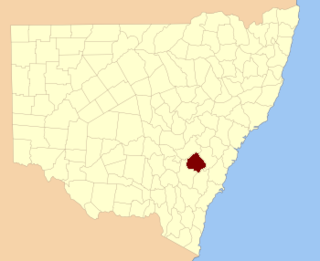
Beresford County is one of the 141 Cadastral divisions of New South Wales. It contains Cooma and Bredbo. Part of the Murrumbidgee River forms the boundary in the north-west, and a separate part of the river forms part of the western boundary.

Buccleuch County Cadastral in New South Wales, Australia

Buccleuch County is one of the 141 Cadastral divisions of New South Wales. It contains the locality of Adjungbilly. The Murrumbidgee River is at the northern boundary, with the Goodradigbee River on the eastern boundary, and the Tumut River on the western boundary. It includes the northern part of the Kosciuszko National Park.

Mitchell County, New South Wales Cadastral in New South Wales, Australia

Mitchell County is one of the 141 Cadastral divisions of New South Wales. It contains the town of Collingullie. The Murrumbidgee River is the northern boundary.

Waradgery County Cadastral in New South Wales, Australia

Waradgery County is one of the 141 Cadastral divisions of New South Wales. It contains the town of Hay. It includes the area between the Lachlan River and the Murrumbidgee River where they meet. The Lachlan River is the northern boundary of the county, and the Murrumbidgee for a small section is the southern boundary, but the county also includes some of the land to the south of the Murrumbidgee near Hay.

Cowper County Cadastral in New South Wales, Australia

Cowper County, New South Wales is one of the 141 Cadastral divisions of New South Wales.

Dampier County Cadastral in New South Wales, Australia

Dampier County is one of the 141 Cadastral divisions of New South Wales. The Deua River is the northern boundary, with land slightly to the north of the Brogo River the southern boundary. It includes Bermagui, Narooma, Bodalla, and most of the Deua National Park and Wadbilliga National Park.

Wallace County, New South Wales Cadastral in New South Wales, Australia

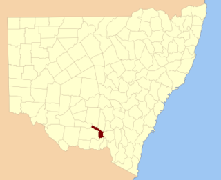
Wallace County is one of the 141 Cadastral divisions of New South Wales. The Snowy River is the boundary to the south and south-east, and the Murrumbidgee River is the northern boundary. It includes the area around Jindabyne.

Wellesley County Cadastral in New South Wales, Australia

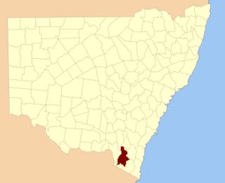
Wellesley County is one of the 141 Cadastral divisions of New South Wales. It is located along the border with Victoria, with the Snowy River part of the northern boundary. It includes Bombala.

The Parish of Wamboin is a parish of the County of Murray, a cadastral unit for use on land titles. It is located just to the north-east of the Australian Capital Territory and includes part of the town of Bungendore on the eastern edge and the rural community of Wamboin near the south-western edge.

Boorowa River river in Australia

Boorowa River, a perennial stream that is part of the Lachlan catchment within the Murray–Darling basin, is located in the central–western region of New South Wales, Australia.

Bowning Creek river in Australia

The Bowning Creek, a mostly–perennial river that is part of the Murrumbidgee catchment within the Murray–Darling basin, is located in the South West Slopes and Riverina regions of New South Wales, Australia.

Derringullen Creek river in Australia

The Derringullen Creek, a mostly–perennial river that is part of the Murrumbidgee catchment within the Murray–Darling basin, is located in the South West Slopes region of New South Wales, Australia.

Good Hope, New South Wales Suburb of Yass Valley Council, New South Wales, Australia

Good Hope is a locality in the Southern Tablelands of New South Wales, Australia in the Yass Valley Shire. It lies south-west of Yass on the northern side of Lake Burrinjuck on the Murrumbidgee River and south of the Yass River. At the 2016 census, it had a population of 165.

References

  1. "King". Geographical Names Register (GNR) of NSW. Geographical Names Board of New South Wales . Retrieved 4 August 2013. OOjs UI icon edit-ltr-progressive.svg