Dowling County

Last updated

Map all coordinates using: OpenStreetMap  
Download coordinates as: KML  ·  GPX
Dowling
New South Wales
Dowling NSW.PNG
Location in New South Wales
Lands administrative divisions around Dowling:
Blaxland Blaxland Cunningham
Franklin Dowling Gipps
Nicholson Cooper Cooper

Dowling County is one of the 141 Cadastral divisions of New South Wales.

Dowling County was named in honour of Judge Sir James Dowling (1787-1844). [1]

James Dowling Australian judge

Sir James Dowling was an English-born Australian jurist in New South Wales, Chief Justice of New South Wales 1837 – 1844.

Parishes within this county

A full list of parishes found within this county; their current LGA and mapping coordinates to the approximate centre of each location is as follows:

Local government in Australia

Local government in Australia is the third tier of government in Australia administered by the states and territories, which in turn are beneath the federal tier. Local government is not mentioned in the Constitution of Australia and two referenda in the 1970s and 1980s to alter the Constitution relating to local government were unsuccessful. Every state government recognises local government in their respective constitutions. Unlike Canada or the United States, there is only one level of local government in each state, with no distinction such as cities and counties.

ParishLGACoordinates
Bimbalingel Lachlan Shire Council 33°18′54″S146°12′04″E / 33.31500°S 146.20111°E / -33.31500; 146.20111 (Bimbalingel)
Bimbil Bland Shire Council 33°37′54″S146°08′04″E / 33.63167°S 146.13444°E / -33.63167; 146.13444 (Bimbil)
Blairgowrie Bland Shire Council 33°37′54″S146°35′04″E / 33.63167°S 146.58444°E / -33.63167; 146.58444 (Blairgowrie)
Bootoowa Lachlan Shire Council 33°24′54″S146°11′04″E / 33.41500°S 146.18444°E / -33.41500; 146.18444 (Bootoowa)
Borapine Lachlan Shire Council 33°18′54″S146°43′04″E / 33.31500°S 146.71778°E / -33.31500; 146.71778 (Borapine)
Brewer Lachlan Shire Council 33°25′54″S146°05′04″E / 33.43167°S 146.08444°E / -33.43167; 146.08444 (Brewer)
Brotheroney Lachlan Shire Council 33°10′54″S146°44′04″E / 33.18167°S 146.73444°E / -33.18167; 146.73444 (Brotheroney)
Cargelligo Lachlan Shire Council 33°22′54″S146°23′04″E / 33.38167°S 146.38444°E / -33.38167; 146.38444 (Cargelligo)
Carilla Carrathool Shire Council 33°24′54″S145°55′04″E / 33.41500°S 145.91778°E / -33.41500; 145.91778 (Carilla)
Carisbrook Lachlan Shire Council 33°28′54″S146°05′04″E / 33.48167°S 146.08444°E / -33.48167; 146.08444 (Carisbrook)
Clowery Bland Shire Council 33°42′54″S146°40′04″E / 33.71500°S 146.66778°E / -33.71500; 146.66778 (Clowery)
Contarlo Lachlan Shire Council 33°28′54″S146°10′04″E / 33.48167°S 146.16778°E / -33.48167; 146.16778 (Contarlo)
Currawong Bland Shire Council 33°34′54″S146°22′04″E / 33.58167°S 146.36778°E / -33.58167; 146.36778 (Currawong)
Curriba Lachlan Shire Council 33°27′54″S146°41′04″E / 33.46500°S 146.68444°E / -33.46500; 146.68444 (Curriba)
Currikabakh Bland Shire Council 33°43′54″S146°30′04″E / 33.73167°S 146.50111°E / -33.73167; 146.50111 (Currikabakh)
Davis Bland Shire Council 33°43′54″S146°07′04″E / 33.73167°S 146.11778°E / -33.73167; 146.11778 (Davis)
Dowling Carrathool Shire Council 33°32′54″S146°03′04″E / 33.54833°S 146.05111°E / -33.54833; 146.05111 (Dowling)
Gainbill Lachlan Shire Council 33°23′54″S146°31′04″E / 33.39833°S 146.51778°E / -33.39833; 146.51778 (Gainbill)
Garryowen Lachlan Shire Council 33°28′54″S146°19′04″E / 33.48167°S 146.31778°E / -33.48167; 146.31778 (Garryowen)
Geelooma Bland Shire Council 33°36′54″S146°40′04″E / 33.61500°S 146.66778°E / -33.61500; 146.66778 (Geelooma)
Guagong Lachlan Shire Council 33°09′54″S146°37′04″E / 33.16500°S 146.61778°E / -33.16500; 146.61778 (Guagong)
Gumbagunda Lachlan Shire Council 33°08′54″S146°29′04″E / 33.14833°S 146.48444°E / -33.14833; 146.48444 (Gumbagunda)
Gurangully Lachlan Shire Council 33°13′54″S146°24′04″E / 33.23167°S 146.40111°E / -33.23167; 146.40111 (Gurangully)
Jimberoo Bland Shire Council 33°43′54″S146°13′04″E / 33.73167°S 146.21778°E / -33.73167; 146.21778 (Jimberoo)
Kikoira Bland Shire Council 33°39′54″S146°40′04″E / 33.66500°S 146.66778°E / -33.66500; 146.66778 (Kikoira)
Killawarra Lachlan Shire Council 33°26′54″S146°30′04″E / 33.44833°S 146.50111°E / -33.44833; 146.50111 (Killawarra)
Lachlan Lachlan Shire Council 33°11′54″S146°20′04″E / 33.19833°S 146.33444°E / -33.19833; 146.33444 (Lachlan)
Merri Merrigal Carrathool Shire Council 33°25′54″S146°00′04″E / 33.43167°S 146.00111°E / -33.43167; 146.00111 (Merri Merrigal)
Mologone Bland Shire Council 33°37′54″S146°15′04″E / 33.63167°S 146.25111°E / -33.63167; 146.25111 (Mologone)
Moneybung Carrathool Shire Council 33°29′54″S146°00′04″E / 33.49833°S 146.00111°E / -33.49833; 146.00111 (Moneybung)
Murrabung Bland Shire Council 33°44′54″S146°24′04″E / 33.74833°S 146.40111°E / -33.74833; 146.40111 (Murrabung)
Naradhan Bland Shire Council 33°43′54″S146°18′04″E / 33.73167°S 146.30111°E / -33.73167; 146.30111 (Naradhan)
Narden Lachlan Shire Council 33°22′54″S146°42′04″E / 33.38167°S 146.70111°E / -33.38167; 146.70111 (Narden)
Narriah Bland Shire Council 33°43′54″S146°34′04″E / 33.73167°S 146.56778°E / -33.73167; 146.56778 (Narriah)
Regent Lachlan Shire Council 33°26′54″S146°17′04″E / 33.44833°S 146.28444°E / -33.44833; 146.28444 (Regent)
Rutland Bland Shire Council 33°37′54″S146°31′04″E / 33.63167°S 146.51778°E / -33.63167; 146.51778 (Rutland)
Tibeaudo Lachlan Shire Council 33°24′54″S146°33′04″E / 33.41500°S 146.55111°E / -33.41500; 146.55111 (Tibeaudo)
Tooronga Lachlan Shire Council 33°22′54″S146°17′04″E / 33.38167°S 146.28444°E / -33.38167; 146.28444 (Tooronga)
Townsend Carrathool Shire Council 33°33′54″S145°59′04″E / 33.56500°S 145.98444°E / -33.56500; 145.98444 (Townsend)
Trigalong Lachlan Shire Council 33°11′54″S146°28′04″E / 33.19833°S 146.46778°E / -33.19833; 146.46778 (Trigalong)
Tuggerabach Lachlan Shire Council 33°28′54″S146°33′04″E / 33.48167°S 146.55111°E / -33.48167; 146.55111 (Tuggerabach)
Uabba Lachlan Shire Council 33°19′54″S146°07′04″E / 33.33167°S 146.11778°E / -33.33167; 146.11778 (Uabba)
Ulambong Lachlan Shire Council 33°13′54″S146°11′04″E / 33.23167°S 146.18444°E / -33.23167; 146.18444 (Ulambong)
Valencia Carrathool Shire Council 33°39′54″S145°58′04″E / 33.66500°S 145.96778°E / -33.66500; 145.96778 (Valencia)
Wardry Lachlan Shire Council 33°04′54″S146°45′04″E / 33.08167°S 146.75111°E / -33.08167; 146.75111 (Wardry)
Whoyeo Lachlan Shire Council 33°18′54″S146°18′04″E / 33.31500°S 146.30111°E / -33.31500; 146.30111 (Whoyeo)
Whyaddra Lachlan Shire Council 33°03′54″S146°38′04″E / 33.06500°S 146.63444°E / -33.06500; 146.63444 (Whyaddra)
Womboyn Bland Shire Council 33°40′54″S146°20′04″E / 33.68167°S 146.33444°E / -33.68167; 146.33444 (Womboyn)
Yarrabundry Lachlan Shire Council 33°17′54″S146°36′04″E / 33.29833°S 146.60111°E / -33.29833; 146.60111 (Yarrabundry)
Yarran Lachlan Shire Council 33°18′54″S146°31′04″E / 33.31500°S 146.51778°E / -33.31500; 146.51778 (Yarran)
Yelkin Lachlan Shire Council 33°27′54″S146°22′04″E / 33.46500°S 146.36778°E / -33.46500; 146.36778 (Yelkin)

Related Research Articles

Dungog, New South Wales Town in New South Wales, Australia

Dungog is a country town on the Williams River in the Hunter Region of New South Wales, Australia. Located in the middle of dairy and timber country, it is the centre of the Dungog Shire local government area and at the 2016 census it had a population of 2,025 people. The area includes the Fosterton Loop, 22 kilometres (14 mi) of road, used in the annual Pedalfest. A small portion of Dungog lies in the Mid-Coast Council LGA.

South Creek (New South Wales) river in New South Wales, Australia

The South Creek or Wianamatta, a creek that is part of the Hawkesbury-Nepean catchment, is located on the Cumberland Plain, also referred to as Greater Western Sydney, New South Wales, Australia.

Zetland, New South Wales Suburb of Sydney, New South Wales, Australia

Zetland is an inner-eastern suburb of Sydney, New South Wales, Australia 4 kilometres south of the Sydney central business district, in the local government area of the City of Sydney.

The Geographical Names Board of New South Wales, a statutory authority of the Land and Property Information division, Department of Finance and Services in the Government of New South Wales, is the official body for naming and recording details of places and geographical names in the state of New South Wales, Australia.

Dowling may refer to:

Darbalara, New South Wales Town in New South Wales, Australia

Darbalara is a rural community on the east bank of the junction of the Murrumbidgee River and Tumut River in the Riverina. It is situated by road, about 25 kilometres north east of Gundagai and 25 kilometres south of Coolac.

Gloucester County, New South Wales Cadastral in New South Wales, Australia

Gloucester County was one of the original Nineteen Counties in New South Wales, and is now one of the 141 cadastral divisions of New South Wales. It includes the area around Port Stephens. It is bounded on the north and west by the Manning River, and on the south-west by the Williams River.

St Vincent County Cadastral in Australian Capital Territory

St Vincent County was one of the original Nineteen Counties in New South Wales and is now one of the 141 Cadastral divisions of New South Wales. It included the south coast area encompassing Batemans Bay, Ulladulla, Jervis Bay and inland to Braidwood. The Shoalhaven River is the boundary to the north and west, and the Deua River the boundary to the south.

Cowper County Cadastral in New South Wales, Australia

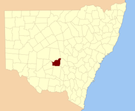
Cowper County, New South Wales is one of the 141 Cadastral divisions of New South Wales.

Mootwingee County Cadastral in New South Wales, Australia

Mootwingee County, New South Wales is one of the 141 Cadastral divisions of New South Wales.

Redfern was an electoral district of the Legislative Assembly in the Australian state of New South Wales, created in 1880, and named after and including the Sydney suburb of Redfern. It extended to Botany Bay and was bordered by Rainbow Street (Randwick), Anzac Parade, the southern edge of Moore Park, South Dowling Street, Cleveland Street, City Road, King Street (Newtown), Alexandra Canal and Cooks River. It elected two members from 1880 to 1882, three members from 1882 to 1887 and four members from 1887 until the abolition of multi-member electorates in 1894, when it was split into Redfern, Botany, Darlington, Waterloo and part of Newtown-Erskine. In 1920, with the introduction of proportional representation, it was absorbed into Botany. It was recreated in 1927 and abolished in 1968.

Sydney-Cook was an electoral district of the Legislative Assembly in the Australian state of New South Wales, created in 1894 in inner Sydney from part of the electoral district of South Sydney and named after James Cook. It was in the Surry Hills area, bounded by Elizabeth Street, Foveaux Street, Riley Street, Tudor Street, Davies Street, Nobbs Street, South Dowling Street, and Cleveland Street. It was abolished in 1904 and partly replaced by Surry Hills.

Sydney-Flinders was an electoral district of the Legislative Assembly in the Australian state of New South Wales, created in 1894 in inner Sydney from part of the electoral district of South Sydney and named after maritime explorer Matthew Flinders. It was in the Surry Hills area, bounded by Riley Street, Oxford Street, South Dowling Street, Nobbs Street, Davies Street and Tudor Street. It was abolished in 1904 and absorbed into the electoral district of Surry Hills.

Dowling, Michigan Census-designated place in Michigan, United States

Dowling is a census-designated place (CDP) in Baltimore Township in Barry County, Michigan, United States. The population was 374 at the 2010 census.

Naradhan Town in New South Wales, Australia

Naradhan is a village and locality in the Central West region of New South Wales Australia. The locality is 452 kilometres (281 mi) from Sydney, the state capital. Naradhan is within the Bland Shire local government area. The village was proclaimed in 1930, and features a shop, primary school, public hall, and the now disused railway station. The town was named after Naradhan a grazing run that was in term probably named for the Wiradjuri term "ngarradan" meaning "bat".

Dowling is a ghost town in Haakon County, in the U.S. state of South Dakota.

Parish of Dowling (Mouramba County)

Dowling Parish in Mouramba County, central New South Wales is a cadasteral parish of Australia. The topography of the parish is generally flat with a thin scrub forest and the main economy of the area is agriculture.

Parish of Dryden

Dowling Parish in Mouramba County, central New South Wales is a cadasteral parish of Australia. The topography of the parish is generally flat with a thin scrub forest and the main economy of the area is agriculture.

Blowering, New South Wales

Blowering, New South wales is a rural locality in the Snowy Mountains of New South wales and a civil Parish of Buccleuch County.

References

  1. "Dowling". Geographical Names Register (GNR) of NSW. Geographical Names Board of New South Wales . Retrieved 4 August 2013. OOjs UI icon edit-ltr-progressive.svg