Thoulcanna County

Last updated

Map all coordinates using: OpenStreetMap  
Download coordinates as: KML  ·  GPX
Thoulcanna
New South Wales
Thoulcanna NSW.PNG
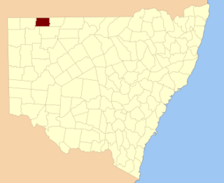
Location in New South Wales
Lands administrative divisions around Thoulcanna:
Queensland Queensland Queensland
Delalah Thoulcanna Irrara
Ularara Ularara Barrona

Thoulcanna County is one of the 141 Cadastral divisions of New South Wales. It is located south of the border with Queensland, to the west of the Paroo River near Wanaaring in the Bourke Shire.

Queensland North-east state of Australia

Queensland is the second-largest and third-most populous state in the Commonwealth of Australia. Situated in the north-east of the country, it is bordered by the Northern Territory, South Australia and New South Wales to the west, south-west and south respectively. To the east, Queensland is bordered by the Coral Sea and Pacific Ocean. To its north is the Torres Strait, with Papua New Guinea located less than 200 km across it from the mainland. The state is the world's sixth-largest sub-national entity, with an area of 1,852,642 square kilometres (715,309 sq mi).

Paroo River river in Queensland and New South Wales, Australia

The Paroo River, a series of waterholes, connected in wet weather as a running stream of the Darling catchment within the Murray–Darling basin, is located in the South West region of Queensland and Far West region of New South Wales, Australia. It is the home of the Paarkantji people.

Bourke Shire Local government area in New South Wales, Australia

Bourke Shire is a local government area in the Orana region of New South Wales, Australia. The Shire is located adjacent to the Darling River, which is known as the Barwon River upstream from Bourke; and located adjacent to the Mitchell Highway. The northern boundary of the Shire is located adjacent to the border between New South Wales and Queensland. The Shire is a wool and beef producing area.

The name Thoulcanna is believed to be derived from a local Aboriginal word and is also the name of the local Thoulcanna Station. [1]

Indigenous Australians are the Aboriginal and Torres Strait Islander peoples of Australia, descended from groups that existed in Australia and surrounding islands before British colonisation. The time of arrival of the first Indigenous peoples on the continent and nearby islands is a matter of debate among researchers. The earliest conclusively human remains found in Australia are those of Mungo Man LM3 and Mungo Lady, which have been dated to around 50,000 years BP. Recent archaeological evidence from the analysis of charcoal and artefacts revealing human use suggests a date as early as 65,000 BP. Luminescence dating has suggested habitation in Arnhem Land as far back as 60,000 years BP. Genetic research has inferred a date of habitation as early as 80,000 years BP. Other estimates have ranged up to 100,000 years and 125,000 years BP.

Parishes within this county

A full list of parishes found within this county; their current LGA and mapping coordinates to the approximate centre of each location is as follows:

Local government in Australia

Local government in Australia is the third tier of government in Australia administered by the states and territories, which in turn are beneath the federal tier. Local government is not mentioned in the Constitution of Australia and two referenda in the 1970s and 1980s to alter the Constitution relating to local government were unsuccessful. Every state government recognises local government in their respective constitutions. Unlike Canada or the United States, there is only one level of local government in each state, with no distinction such as cities and counties.

ParishLGACoordinates
Clear Water Unincorporated 29°22′42″S144°17′32″E / 29.37833°S 144.29222°E / -29.37833; 144.29222 (Clear Water)
Colaine Unincorporated 29°33′01″S143°42′38″E / 29.55028°S 143.71056°E / -29.55028; 143.71056 (Colaine)
Currabenya Unincorporated 29°06′35″S143°44′49″E / 29.10972°S 143.74694°E / -29.10972; 143.74694 (Currabenya)
Davis Unincorporated 29°10′21″S143°58′15″E / 29.17250°S 143.97083°E / -29.17250; 143.97083 (Davis)
Davison Unincorporated 29°22′43″S143°41′57″E / 29.37861°S 143.69917°E / -29.37861; 143.69917 (Davison)
EurimbulaUnincorporated
Evelyn Unincorporated 29°20′43″S144°22′20″E / 29.34528°S 144.37222°E / -29.34528; 144.37222 (Evelyn)
Feehan Unincorporated 29°13′54″S144°04′46″E / 29.23167°S 144.07944°E / -29.23167; 144.07944 (Feehan)
Flood Unincorporated 29°15′19″S143°42′09″E / 29.25528°S 143.70250°E / -29.25528; 143.70250 (Flood)
Kelly Unincorporated 29°13′36″S144°24′33″E / 29.22667°S 144.40917°E / -29.22667; 144.40917 (Kelly)
Kerrininna Unincorporated 29°10′07″S144°23′25″E / 29.16861°S 144.39028°E / -29.16861; 144.39028 (Kerrininna)
Nardoo Unincorporated 29°31′56″S144°08′49″E / 29.53222°S 144.14694°E / -29.53222; 144.14694 (Nardoo)
Newland Unincorporated 29°09′44″S144°11′12″E / 29.16222°S 144.18667°E / -29.16222; 144.18667 (Newland)
Odonnell Unincorporated 29°13′46″S144°15′27″E / 29.22944°S 144.25750°E / -29.22944; 144.25750 (Odonnell)
Stony Ridge Unincorporated 29°28′59″S144°17′56″E / 29.48306°S 144.29889°E / -29.48306; 144.29889 (Stony Ridge)
Talyeale Unincorporated 29°01′21″S144°07′50″E / 29.02250°S 144.13056°E / -29.02250; 144.13056 (Talyeale)
Waverley Unincorporated 29°06′01″S143°58′16″E / 29.10028°S 143.97111°E / -29.10028; 143.97111 (Waverley)
Willera Unincorporated 29°26′38″S143°53′50″E / 29.44389°S 143.89722°E / -29.44389; 143.89722 (Willera)
Yernca Bourke Shire 29°34′09″S144°23′49″E / 29.56917°S 144.39694°E / -29.56917; 144.39694 (Yernca)

Related Research Articles

South Creek (New South Wales) river in New South Wales, Australia

The South Creek or Wianamatta, a creek that is part of the Hawkesbury-Nepean catchment, is located on the Cumberland Plain, also referred to as Greater Western Sydney, New South Wales, Australia.

The Geographical Names Board of New South Wales, a statutory authority of the Land and Property Information division, Department of Finance and Services in the Government of New South Wales, is the official body for naming and recording details of places and geographical names in the state of New South Wales, Australia.

Northumberland County, New South Wales Cadastral in New South Wales, Australia

Northumberland County was one of the original Nineteen Counties in New South Wales and is now one of the 141 Cadastral divisions of New South Wales. It included the area to the north of Broken Bay, including Lake Macquarie and Newcastle. It was bounded by the part of the Hawkesbury River to the south, the Macdonald River to the south-west, and the Hunter River to the north.

Harden County Cadastral in New South Wales, Australia

Harden County is one of the 141 cadastral divisions of New South Wales. It contains the town of Harden.

Delalah County Cadastral in New South Wales, Australia

Delalah County is one of the 141 Cadastral divisions of New South Wales.

Irrara County Cadastral in New South Wales, Australia

Irrara County is one of the 141 Cadastral divisions of New South Wales. It is located south of the border with Queensland, east of the Paroo River, and west of the Warrego River.

Mootwingee County Cadastral in New South Wales, Australia

Mootwingee County, New South Wales is one of the 141 Cadastral divisions of New South Wales.

Yantara County Cadastral in New South Wales, Australia

Yantara County is one of the 141 Cadastral divisions of New South Wales.

Parish of Thoulcanna

Thoulcanna, New South Wales is a remote civil Parish, of the County of Delalah, a cadasteral division of New South Wales.

Currabenya, New South Wales

Currabenya, New South Wales is a remote rural locality and civil Parish, of Thoulcanna County, a cadasteral division of New South Wales.

Flood Parish (Thoulcanna County), New South Wales

Flood Parish, New South Wales is a remote rural locality and civil Parish, of Thoulcanna County, a cadasteral division of New South Wales.

Waverley Parish (Thoulcanna County), New South Wales

Waverley Parish, New South Wales is a remote civil Parish, of the Thoulcanna County, a cadasteral division of New South Wales.

Talyeale, New South Wales

Talyeale, New South Wales is a remote rural locality and civil Parish, of the Thoulcanna County, a cadasteral division of New South Wales.

Kerrininna, New South Wales

Kerrininna, New South Wales is a remote rural locality and civil Parish, of the Thoulcanna County a cadasteral division of New South Wales. Kerrininna Parish is on the Paroo River south of Hungerford, Queensland.

Kelly Parish (Thoulcanna County), New South Wales

Kelly Parish is a remote rural locality on the Paroo River and a civil Parish, of the Thoulcanna County a cadasteral division of New South Wales.

Evelyn Parish (Thoulcanna County ), New South Wales

Evelyn Parish, on the Paroo River, is a remote civil Parish, of Thoulcanna County, a cadasteral division of New South Wales.

Stony Ridge, New South Wales

Stoney Ridge is a remote rural locality on the Paroo River and a civil Parish, of the Thoulcanna County a cadasteral division of New South Wales.

Yernca is a rural locality of Bourke Shire located at 29°34′09″S 144°23′49″E and a remote civil Parish, of the Thoulcanna County a cadasteral division of New South Wales.

References

  1. "Thoulcanna". Geographical Names Register (GNR) of NSW. Geographical Names Board of New South Wales . Retrieved 4 August 2013. OOjs UI icon edit-ltr-progressive.svg