
Flood Parish, New South Wales is a remote rural locality and civil Parish, of Thoulcanna County, [1] a cadasteral division of New South Wales. [2]
Flood Parish, New South Wales is a remote rural locality and civil Parish, of Thoulcanna County, [1] a cadasteral division of New South Wales. [2]
The topography is the flat and arid with a Köppen climate classification of Bwh (Desert). [3]
The economy in the parish is based on broad acre agriculture, mainly Cattle, and there are no towns in the parish and the nearest settlement is Hungerford, Queensland and Wanaaring, New South Wales, with Tibooburra, New South Wales further to the west. The parish will be the site of a Total Solar Eclipse on 25 Nov, 2030. [4]
The parish is on the traditional land of the Bardadji people, and in the 1890s was included in the Albert Gold Fields. The parish was part of Berawinna Downs Station in the 20th century.

Torrens Parish, New South Wales located at 29°14′00″S 142°09′27″E is a rural locality in and a cadastral parish of Tongowoko County, two kilometers north east from the town of Tibooburra, New South Wales. The parish is north east of Tibooburra, within the Sturt National Park.
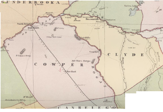
Edenhope Parish, New South Wales is a Bounded locality of Bogan Shire and a civil Parish of Cowper County, New South Wales, a cadasteral division of central New South Wales.
Maffra Parish, New South Wales is a Bounded locality of Bourke Shire and a civil Parish of Cowper County, New South Wales, a cadasteral division of central New South Wales.

Garfield Parish, New South Wales is a civil Parish of Cowper County, New South Wales, a cadasteral division of central New South Wales.
Thoulcanna, New South Wales is a remote civil Parish, of the County of Delalah, a cadasteral division of New South Wales.
Berawinia, New South Wales is a remote civil Parish, of the County of Delalah, a cadasteral division of New South Wales.
Catombal Parish, New South Wales is a civil Parish, of the County of Delalah, a cadasteral division of New South Wales.

Currabenya, New South Wales is a remote rural locality and civil Parish, of Thoulcanna County, a cadasteral division of New South Wales.
Waverley Parish, New South Wales is a remote civil Parish, of the Thoulcanna County, a cadasteral division of New South Wales.
Talyeale, New South Wales is a remote rural locality and civil Parish, of the Thoulcanna County, a cadasteral division of New South Wales.
Kerrininna, New South Wales is a remote rural locality and civil Parish, of the Thoulcanna County a cadasteral division of New South Wales. Kerrininna Parish is on the Paroo River south of Hungerford, Queensland.
Kelly Parish is a remote rural locality on the Paroo River and a civil Parish, of the Thoulcanna County a cadasteral division of New South Wales.
Evelyn Parish, on the Paroo River, is a remote civil Parish, of Thoulcanna County, a cadasteral division of New South Wales.
Stoney Ridge is a remote rural locality on the Paroo River and a civil Parish, of the Thoulcanna County a cadasteral division of New South Wales.
Yernca is a rural locality of Bourke Shire located at 29°34′09″S 144°23′49″E and a remote civil Parish, of the Thoulcanna County a cadasteral division of New South Wales.
Berawinnia Parish, New South Wales is a remote civil parish, of Irrara County, a cadasteral division of New South Wales.
Mucruss Parish, New South Wales is a remote civil Parish, of Irrara County, a cadasteral division of New South Wales.
Kenmare Parish is a remote civil Parish, of Irrara County, a cadasteral division of New South Wales.
Moolort Parish is a remote civil Parish, of Irrara County, a cadasteral division of New South Wales. Moortlort is on te Queensland-New South Wales border just east of Hungerford, Queensland.
Warroo Parish is a remote civil Parish, of Irrara County, a cadasteral division of New South Wales. Warroo Parish is on the Queensland-New South Wales border just east of Hungerford, Queensland.
| This Far West geography article is a stub. You can help Wikipedia by expanding it. |