Evelyn Parish (Thoulcanna County ), New South Wales

Last updated

Thoulcanna County Thoulcanna NSW.PNG
Thoulcanna County

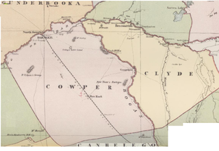
Evelyn Parish, on the Paroo River, is a remote civil Parish, of Thoulcanna County, [1] a cadasteral division of New South Wales. [2]

Paroo River river in Queensland and New South Wales, Australia

The Paroo River, a series of waterholes, connected in wet weather as a running stream of the Darling catchment within the Murray–Darling basin, is located in the South West region of Queensland and Far West region of New South Wales, Australia. It is the home of the Paarkantji people.

Thoulcanna County Cadastral in New South Wales, Australia

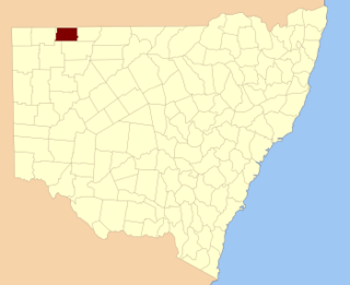
Thoulcanna County is one of the 141 Cadastral divisions of New South Wales. It is located south of the border with Queensland, to the west of the Paroo River near Wanaaring in the Bourke Shire.

New South Wales State of Australia

New South Wales is a state on the east coast of Australia. It borders Queensland to the north, Victoria to the south, and South Australia to the west. Its coast borders the Tasman Sea to the east. The Australian Capital Territory is an enclave within the state. New South Wales' state capital is Sydney, which is also Australia's most populous city. In September 2018, the population of New South Wales was over 8 million, making it Australia's most populous state. Just under two-thirds of the state's population, 5.1 million, live in the Greater Sydney area. Inhabitants of New South Wales are referred to as New South Welshmen.

The topography is the flat and arid with a Köppen climate classification of BSh (Hot semi arid) [3] and the economy is based on broad acre agriculture, mainly Cattle, and sheep. There are no towns in the parish and Evelyn Parish is midway between Hungerford, Queensland and Wanaaring, New South Wales to the south.

Topography The study of the shape and features of the surface of the Earth and other observable astronomical objects

Topography is the study of the shape and features of land surfaces. The topography of an area could refer to the surface shapes and features themselves, or a description.

Arid severe lack of available water

A region is arid when it is characterized by a severe lack of available water, to the extent of hindering or preventing the growth and development of plant and animal life. Environments subject to arid climates tend to lack vegetation and are called xeric or desertic. Most "arid" climates straddle the Equator; these places include parts of Africa, South America, Central America, and Australia.

Köppen climate classification climate classification system

The Köppen climate classification is one of the most widely used climate classification systems. It was first published by the German-Russian climatologist Wladimir Köppen (1846–1940) in 1884, with several later modifications by Köppen, notably in 1918 and 1936. Later, the climatologist Rudolf Geiger introduced some changes to the classification system, which is thus sometimes called the Köppen–Geiger climate classification system.

The parish is on the traditional lands of the Barundji people.

See also

Related Research Articles

Maffra, New South Wales Parish of Cowper County, New South Wales, Australia

Maffra Parish, New South Wales is a Bounded locality of Bourke Shire and a civil Parish of Cowper County, New South Wales, a cadasteral division of central New South Wales.

Mulgawarrina, New South Wales

Mulgawarrina, New South Wales is a Bounded locality of Brewarrina Shire and a civil Parish of Cowper County, New South Wales, a cadasteral division of central New South Wales.

Tubba Parish (Cowper County), New South Wales

Mulgawarrina, New South Wales is a Bounded locality of Bogan Shire and a civil Parish of Cowper County, New South Wales, a cadasteral division of central New South Wales.

Garfield Parish (Cowper County), New South Wales

Garfield Parish, New South Wales is a civil Parish of Cowper County, New South Wales, a cadasteral division of central New South Wales.

Parish of Korri

Korri Parish is a remote civil Parish, of the County of Delalah a cadasteral division of New South Wales.

Parish of Cullamulcha

Cullamulcha, New South Wales is a civil Parish, of the County of Delalah, a cadasteral division of New South Wales.

Parish of Thoulcanna

Thoulcanna, New South Wales is a remote civil Parish, of the County of Delalah, a cadasteral division of New South Wales.

Parish of Elsinora

Elsinora, New South Wales is a civil Parish, of the County of Delalah, a cadasteral division of New South Wales.

Parish of Catombal (Delalah County)

Catombal Parish, New South Wales is a civil Parish, of the County of Delalah, a cadasteral division of New South Wales.

Parish of Border

Border, New South Wales is a remote civil Parish, of the County of Delalah a cadasteral division of New South Wales.

Currabenya, New South Wales

Currabenya, New South Wales is a remote rural locality and civil Parish, of Thoulcanna County, a cadasteral division of New South Wales.

Flood Parish (Thoulcanna County), New South Wales

Flood Parish, New South Wales is a remote rural locality and civil Parish, of Thoulcanna County, a cadasteral division of New South Wales.

Waverley Parish (Thoulcanna County), New South Wales

Waverley Parish, New South Wales is a remote civil Parish, of the Thoulcanna County, a cadasteral division of New South Wales.

Talyeale, New South Wales

Talyeale, New South Wales is a remote rural locality and civil Parish, of the Thoulcanna County, a cadasteral division of New South Wales.

Kerrininna, New South Wales

Kerrininna, New South Wales is a remote rural locality and civil Parish, of the Thoulcanna County a cadasteral division of New South Wales. Kerrininna Parish is on the Paroo River south of Hungerford, Queensland.

Kelly Parish (Thoulcanna County), New South Wales

Kelly Parish is a remote rural locality on the Paroo River and a civil Parish, of the Thoulcanna County a cadasteral division of New South Wales.

Stony Ridge, New South Wales

Stoney Ridge is a remote rural locality on the Paroo River and a civil Parish, of the Thoulcanna County a cadasteral division of New South Wales.

Yernca is a rural locality of Bourke Shire located at 29°34′09″S 144°23′49″E and a remote civil Parish, of the Thoulcanna County a cadasteral division of New South Wales.

Tantawanga (Barrona County parish)

Tantawanga Parish is a remote civil Parish, of the County of Barrona, a cadasteral division of New South Wales.

Byjerk Parish is a remote civil Parish, of the County of Barrona, a cadasteral division of New South Wales.

References

  1. Map of the County of Thoulcanna, Western Division, N.S.W., 1914 (Department of Lands, Sydney N.S.W, 1914).
  2. "Thoulcanna". Geographical Names Register (GNR) of NSW. Geographical Names Board of New South Wales . Retrieved 4 August 2013. OOjs UI icon edit-ltr-progressive.svg
  3. Peel, M. C.; Finlayson, B. L.; McMahon, T. A. (2007). "Updated world map of the Köppen–Geiger climate classification". Hydrol. Earth Syst. Sci. 11: 1633–1644. doi:10.5194/hess-11-1633-2007. ISSN   1027-5606.(direct: Final Revised Paper)