Livingstone County, New South Wales

Last updated

Map all coordinates using: OpenStreetMap
Livingstone
New South Wales
Livingstone NSW.PNG
Location in New South Wales
Lands administrative divisions around Livingstone:
Tandora Young Werunda
Menindee Livingstone Woore
Windeyer Perry Manara

Livingstone County is one of the 141 Cadastral divisions of New South Wales. The Darling River is the western and north-western boundary, near Menindee.

Livingstone County was named in honour after the African missionary and explorer David Livingstone (1813-1873). [1]

Parishes within this county

A full list of parishes found within this county; their current LGA and mapping coordinates to the approximate centre of each location is as follows:

ParishLGACoordinates
Albemarle Central Darling Shire 32°19′13″S142°39′40″E / 32.32028°S 142.66111°E / -32.32028; 142.66111 (Albemarle)
Arlington Central Darling Shire 32°27′30″S143°45′32″E / 32.45833°S 143.75889°E / -32.45833; 143.75889 (Arlington)
Ashbourne Central Darling Shire 32°19′46″S143°23′35″E / 32.32944°S 143.39306°E / -32.32944; 143.39306 (Ashbourne)
Berangabah Central Darling Shire 32°29′45″S143°31′58″E / 32.49583°S 143.53278°E / -32.49583; 143.53278 (Berangabah)
Billitong Central Darling Shire 32°08′26″S143°10′52″E / 32.14056°S 143.18111°E / -32.14056; 143.18111 (Billitong)
Bindi Central Darling Shire 32°27′48″S143°12′01″E / 32.46333°S 143.20028°E / -32.46333; 143.20028 (Bindi)
Blenalben Central Darling Shire 32°22′43″S143°49′06″E / 32.37861°S 143.81833°E / -32.37861; 143.81833 (Blenalben)
Blenheim Central Darling Shire 32°21′22″S142°31′28″E / 32.35611°S 142.52444°E / -32.35611; 142.52444 (Blenheim)
Boliva Central Darling Shire 32°38′00″S142°51′31″E / 32.63333°S 142.85861°E / -32.63333; 142.85861 (Boliva)
Boolaboolka Central Darling Shire 32°36′04″S143°12′44″E / 32.60111°S 143.21222°E / -32.60111; 143.21222 (Boolaboolka)
Boomery Central Darling Shire 32°16′03″S143°13′47″E / 32.26750°S 143.22972°E / -32.26750; 143.22972 (Boomery)
Boonditti Central Darling Shire 32°21′29″S142°56′52″E / 32.35806°S 142.94778°E / -32.35806; 142.94778 (Boonditti)
Boonoona Central Darling Shire 32°38′47″S143°01′52″E / 32.64639°S 143.03111°E / -32.64639; 143.03111 (Boonoona)
Boothingalla Central Darling Shire 32°11′41″S143°02′23″E / 32.19472°S 143.03972°E / -32.19472; 143.03972 (Boothingalla)
Brainerd Central Darling Shire 31°59′37″S143°10′19″E / 31.99361°S 143.17194°E / -31.99361; 143.17194 (Brainerd)
Brunker Central Darling Shire 31°56′48″S143°04′41″E / 31.94667°S 143.07806°E / -31.94667; 143.07806 (Brunker)
Burndoo Central Darling Shire 32°09′35″S143°41′52″E / 32.15972°S 143.69778°E / -32.15972; 143.69778 (Burndoo)
Clifford Central Darling Shire 31°52′13″S143°10′58″E / 31.87028°S 143.18278°E / -31.87028; 143.18278 (Clifford)
Connulpie Central Darling Shire 32°39′58″S143°22′18″E / 32.66611°S 143.37167°E / -32.66611; 143.37167 (Connulpie)
Conolly Central Darling Shire 32°36′22″S142°36′31″E / 32.60611°S 142.60861°E / -32.60611; 142.60861 (Conolly)
Coveney Central Darling Shire 32°04′06″S143°19′15″E / 32.06833°S 143.32083°E / -32.06833; 143.32083 (Coveney)
Cowary Central Darling Shire unknown
Culpaulin Central Darling Shire unknown
Dromore Central Darling Shire 32°23′21″S143°34′20″E / 32.38917°S 143.57222°E / -32.38917; 143.57222 (Cowary)
Gemini Central Darling Shire 32°24′40″S142°40′21″E / 32.41111°S 142.67250°E / -32.41111; 142.67250 (Gemini)
Gordon Central Darling Shire 32°25′40″S142°50′09″E / 32.42778°S 142.83583°E / -32.42778; 142.83583 (Gordon)
Haribel Central Darling Shire 32°00′24″S143°20′00″E / 32.00667°S 143.33333°E / -32.00667; 143.33333 (Haribel)
Huco Central Darling Shire 32°35′03″S143°02′22″E / 32.58417°S 143.03944°E / -32.58417; 143.03944 (Huco)
Hudson Central Darling Shire 32°17′53″S143°44′48″E / 32.29806°S 143.74667°E / -32.29806; 143.74667 (Hudson)
Liddell Central Darling Shire 32°12′38″S142°43′30″E / 32.21056°S 142.72500°E / -32.21056; 142.72500 (Liddell)
Makingah Central Darling Shire 32°32′52″S142°37′02″E / 32.54778°S 142.61722°E / -32.54778; 142.61722 (Makingah)
Mandy Central Darling Shire 32°41′50″S142°45′01″E / 32.69722°S 142.75028°E / -32.69722; 142.75028 (Mandy)
Marlborough Central Darling Shire 31°48′33″S143°16′31″E / 31.80917°S 143.27528°E / -31.80917; 143.27528 (Marlborough)
Marle Central Darling Shire 32°02′18″S143°32′31″E / 32.03833°S 143.54194°E / -32.03833; 143.54194 (Marle)
Minden Central Darling Shire 32°09′47″S143°22′24″E / 32.16306°S 143.37333°E / -32.16306; 143.37333 (Minden)
Mourte Central Darling Shire 32°31′02″S142°46′30″E / 32.51722°S 142.77500°E / -32.51722; 142.77500 (Mourte)
Mundy Central Darling Shire 32°17′01″S142°51′56″E / 32.28361°S 142.86556°E / -32.28361; 142.86556 (Mundy)
Newcome Central Darling Shire 32°11′14″S142°51′16″E / 32.18722°S 142.85444°E / -32.18722; 142.85444 (Newcome)
Pysant Central Darling Shire 32°18′14″S143°03′13″E / 32.30389°S 143.05361°E / -32.30389; 143.05361 (Pysant)
Repton Central Darling Shire 32°01′13″S143°01′40″E / 32.02028°S 143.02778°E / -32.02028; 143.02778 (Repton)
Sadlier Central Darling Shire 32°23′27″S143°03′42″E / 32.39083°S 143.06167°E / -32.39083; 143.06167 (Sadlier)
Steel Central Darling Shire 32°25′11″S142°30′49″E / 32.41972°S 142.51361°E / -32.41972; 142.51361 (Steel)
Surbiton Central Darling Shire 32°08′45″S142°53′14″E / 32.14583°S 142.88722°E / -32.14583; 142.88722 (Surbiton)
Talyawalka Central Darling Shire 32°28′57″S142°27′25″E / 32.48250°S 142.45694°E / -32.48250; 142.45694 (Talyawalka)
Teryawinya Central Darling Shire 32°28′07″S143°22′21″E / 32.46861°S 143.37250°E / -32.46861; 143.37250 (Teryawinya)
Tintinalogy Central Darling Shire 32°09′12″S143°02′11″E / 32.15333°S 143.03639°E / -32.15333; 143.03639 (Tintinalogy)
Toorincaca Central Darling Shire 32°32′21″S142°52′20″E / 32.53917°S 142.87222°E / -32.53917; 142.87222 (Toorincaca)
Undeathi Central Darling Shire 32°31′18″S142°27′11″E / 32.52167°S 142.45306°E / -32.52167; 142.45306 (Undeathi)
Victoria Central Darling Shire 32°36′24″S143°24′08″E / 32.60667°S 143.40222°E / -32.60667; 143.40222 (Victoria)
Wambah Central Darling Shire 32°24′38″S142°25′22″E / 32.41056°S 142.42278°E / -32.41056; 142.42278 (Wambah)
Wanalla Central Darling Shire 32°15′34″S143°33′20″E / 32.25944°S 143.55556°E / -32.25944; 143.55556 (Wanalla)
Weatherly Central Darling Shire 32°04′56″S143°09′24″E / 32.08222°S 143.15667°E / -32.08222; 143.15667 (Weatherly)
Widgera Central Darling Shire 32°21′48″S143°12′55″E / 32.36333°S 143.21528°E / -32.36333; 143.21528 (Widgera)
Yenda Central Darling Shire unknown

Related Research Articles

<span class="mw-page-title-main">David Livingstone</span> British colonialist and missionary to Africa (1813–1873)

David Livingstone was a Scottish physician, Congregationalist, pioneer Christian missionary with the London Missionary Society, and an explorer in Africa. David was the husband of Mary Moffat Livingstone, from the prominent 18th-century missionary family, Moffat. Livingstone had a mythic status that operated on a number of interconnected levels: Protestant missionary martyr, working-class "rags-to-riches" inspirational story, scientific investigator and explorer, imperial reformer, anti-slavery crusader, and advocate of British commercial and colonial expansion. As a result, Livingstone became one of the most popular British heroes of the late 19th-century Victorian era.

<span class="mw-page-title-main">Thomas Mitchell (explorer)</span> Scottish surveyor and explorer of south-eastern Australia (1792-1855)

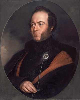
Sir Thomas Livingstone Mitchell, often called Major Mitchell, was a Scottish surveyor and explorer of Southeastern Australia. He was born in Scotland and served in the British Army during the Peninsular War. In 1827 he took up an appointment as Assistant Surveyor General of New South Wales. The following year he became Surveyor General and remained in this position until his death. Mitchell was knighted in 1839 for his contribution to the surveying of Australia.

<span class="mw-page-title-main">South Creek (New South Wales)</span> Creek in Sydney, Australia

The South Creek or Wianamatta is a creek that is part of the Hawkesbury-Nepean catchment, located on the Cumberland Plain in Greater Western Sydney, New South Wales, Australia.

<span class="mw-page-title-main">Shire of Livingstone</span> Local government area in Queensland, Australia

The Shire of Livingstone is a local government area located in the Capricornia region of Central Queensland, Queensland, Australia, to the immediate north and east of the regional city of Rockhampton. The shire, administered from the coastal town of Yeppoon, covers an area of 11,758 square kilometres (4,539.8 sq mi), and existed as a local government entity from 1879 until 2008, when it amalgamated with several other councils to become the Rockhampton Region. The Shire was re-established on 1 January 2014 following a successful de-amalgamation referendum in 2013.

<span class="mw-page-title-main">Yass River</span> River in New South Wales, Australia

The Yass River, a perennial river that is part of the Murrumbidgee catchment within the Murray–Darling basin, is located in the Southern Tablelands and South Western Slopes districts of New South Wales, Australia.

<span class="mw-page-title-main">Darbalara, New South Wales</span> Town in New South Wales, Australia

Darbalara is a rural community on the east bank of the junction of the Murrumbidgee River and Tumut River in the Riverina. It is situated by road, about 25 kilometres north east of Gundagai and 25 kilometres south of Coolac.

<span class="mw-page-title-main">Camden County, New South Wales</span> Cadastral in New South Wales, Australia

Camden County was one of the original Nineteen Counties in New South Wales and is now one of the 141 Cadastral divisions of New South Wales. It included the coastal area near Wollongong south to the Shoalhaven River, and also inland encompassing Berrima and Picton. Its western boundary was the Wollondilly River. The first settlement in the area was Camden Park, established by John Macarthur in 1806, just across the Nepean River from Cumberland County. It was the first land across the Nepean to be settled. Camden is a present-day suburb of Sydney in the same area, although parts of it are in Cumberland.

<span class="mw-page-title-main">Townsend County</span> Cadastral in New South Wales, Australia

Townsend County is one of the 141 Cadastral divisions of New South Wales. It is in the south of New South Wales with the Murray River to the south. Deniliquin is located there.

<span class="mw-page-title-main">Buccleuch County</span> Cadastral in New South Wales, Australia

Buccleuch County is one of the 141 Cadastral divisions of New South Wales. It contains the locality of Adjungbilly. The Murrumbidgee River is at the northern boundary, with the Goodradigbee River on the eastern boundary, and the Tumut River on the western boundary. It includes the northern part of the Kosciuszko National Park.

<span class="mw-page-title-main">Mitchell County, New South Wales</span> Cadastral in New South Wales, Australia

Mitchell County is one of the 141 Cadastral divisions of New South Wales. It contains the town of Collingullie. The Murrumbidgee River is the northern boundary.

<span class="mw-page-title-main">Irrara County</span> Cadastral in New South Wales, Australia

Irrara County is one of the 141 Cadastral divisions of New South Wales. It is located south of the border with Queensland, east of the Paroo River, and west of the Warrego River.

<span class="mw-page-title-main">Tongowoko County</span> Cadastral in New South Wales, Australia

Tongowoko County is one of the 141 Cadastral divisions of New South Wales. It is located in the remote north-west of the state, south of the Queensland border.

<span class="mw-page-title-main">Cobrabald River</span> River in New South Wales, Australia

Cobrabald River, a mostly perennial river that is part of the Namoi catchment within the Murray–Darling basin, is located in the Northern Tablelands district of New South Wales, Australia.

Little Murray River, an anabranch of the Murray River and part of the Murray–Darling basin, is located in the western Riverina region of south western New South Wales, Australia.

Phils River, a watercourse that is part of the Lachlan catchment within the Murray–Darling basin, is located in the central western region of New South Wales, Australia.

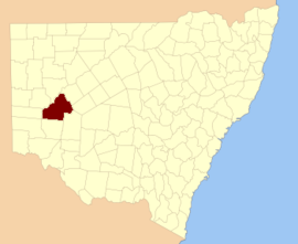
Livingstone is a national park and state conservation area located 30 kilometres (19 mi) south of Wagga Wagga and 10 kilometres (6.2 mi) east of Mangoplah, in the South West Slopes region of south western New South Wales.

<span class="mw-page-title-main">County of Livingstone, Queensland</span> Cadastral in Queensland, Australia

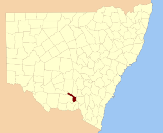
The County of Livingstone is a county in Queensland, Australia. It is centred on the city of Rockhampton and includes most of the Rockhampton Region. The county was created on 1 September 1855 by royal proclamation under the Waste Lands Australia Act 1846. On 7 March 1901, the Governor issued a proclamation legally dividing Queensland into counties under the Land Act 1897. Its schedule described Livingstone thus:

Bounded on the south by the county of Deas Thompson and the southern boundaries of the parishes of Plews, Bouldercombe, Mooninera and Playfair; on the west by the western boundaries of the parishes of Playfair, Stanwell, Neerkol, Limestone, Morinish, Yaamba, Canoona and Werribee; on the north by the northern boundaries of the parishes of Werribee, Rosslynn and Yeppoon, and on the east by the Pacific Ocean,—inclusive of Great Keppel, North Keppel, and other adjacent islands.

<span class="mw-page-title-main">County of Raglan</span> Cadastral in Queensland, Australia

The County of Raglan is a county in Queensland, Australia, located mostly within the Shire of Banana in Central Queensland. The county was first created in January 1854 by the office of the Colonial Secretary of New South Wales. On 7 March 1901, the Governor issued a proclamation legally dividing Queensland into counties under the Land Act 1897. Its schedule described Raglan thus:

Bounded on the south by the southern boundaries of Winterbourne, Callide and Prairie; on the west by the western boundaries of the parishes of Prairie, Spier, Earlsfield, Bundalba, Dundee, Gelobera and Calliungal; on the north by the county of Livingstone; and on the east by the counties of Livingstone, Deas Thompson, and Clinton.

Liam Stephen Livingstone is an English cricketer who plays for Lancashire and England. Livingstone is a right-handed batter and spin bowler, capable of bowling both right-arm leg and off spin. He made his Twenty20 debut for Lancashire against Leicestershire in May 2015. He was awarded the Most Valuable Player in the ECB's inaugural The Hundred competition. He was a member of the England team that won the 2022 T20 World Cup.

<span class="mw-page-title-main">Blowering, New South Wales</span> Town in New South Wales, Australia

Blowering, New South wales is a rural locality in the Snowy Mountains of New South wales and a civil Parish of Buccleuch County.

References

  1. "Livingstone County". Geographical Names Register (GNR) of NSW. Geographical Names Board of New South Wales. OOjs UI icon edit-ltr-progressive.svg