Young County, New South Wales

Last updated

Map all coordinates using: OpenStreetMap  
Download coordinates as: KML  ·  GPX
Young
New South Wales
Young NSW.PNG
Location in New South Wales
Lands administrative divisions around Young:
Mootwingee Yungnulgra Killara
Mootwingee Young Werunda
Tandora Livingstone Livingstone

Young County is one of the 141 Cadastral divisions of New South Wales. It includes the area to the west of Wilcannia. The Darling River is the south-eastern boundary.

Young County was named in honour of the twelfth Governor of New South Wales, Sir John Young, First Baron Lisgar (1807-1876). [1]

Parishes within this county

A full list of parishes found within this county; their current LGA and mapping coordinates to the approximate centre of each location is as follows:

ParishLGACoordinates
Ardennes Unincorporated 31°24′20″S142°38′27″E / 31.40556°S 142.64083°E / -31.40556; 142.64083 (Ardennes)
Barbston Central Darling Shire 31°11′21″S143°02′42″E / 31.18917°S 143.04500°E / -31.18917; 143.04500 (Barbston)
Baroorangee Unincorporated 31°13′50″S142°28′52″E / 31.23056°S 142.48111°E / -31.23056; 142.48111 (Baroorangee)
Blanche Unincorporated 31°13′56″S142°35′44″E / 31.23222°S 142.59556°E / -31.23222; 142.59556 (Blanche)
Blumenthal Central Darling Shire 31°31′12″S143°07′00″E / 31.52000°S 143.11667°E / -31.52000; 143.11667 (Blumenthal)
Bonley Central Darling Shire 31°49′31″S143°05′13″E / 31.82528°S 143.08694°E / -31.82528; 143.08694 (Bonley)
Brougham Central Darling Shire 31°27′37″S143°13′52″E / 31.46028°S 143.23111°E / -31.46028; 143.23111 (Brougham)
Broughton Unincorporated 31°38′06″S142°39′29″E / 31.63500°S 142.65806°E / -31.63500; 142.65806 (Broughton)
Bungaroo Unincorporated 31°30′37″S142°31′49″E / 31.51028°S 142.53028°E / -31.51028; 142.53028 (Bungaroo)
Cameron Central Darling Shire 31°18′36″S143°13′05″E / 31.31000°S 143.21806°E / -31.31000; 143.21806 (Cameron)
Clayton Unincorporated 31°38′42″S142°45′23″E / 31.64500°S 142.75639°E / -31.64500; 142.75639 (Clayton)
Cobrilla Central Darling Shire
Comarto Central Darling Shire 31°25′18″S142°46′55″E / 31.42167°S 142.78194°E / -31.42167; 142.78194 (Comarto)
Corega Central Darling Shire 32°03′16″S142°55′10″E / 32.05444°S 142.91944°E / -32.05444; 142.91944 (Corega)
Coromerry Central Darling Shire 31°38′59″S143°17′48″E / 31.64972°S 143.29667°E / -31.64972; 143.29667 (Coromerry)
Culpaulin Central Darling Shire
Cuthowara Unincorporated 31°35′39″S142°45′22″E / 31.59417°S 142.75611°E / -31.59417; 142.75611 (Cuthowara)
Dalglish Central Darling Shire 31°41′22″S142°52′10″E / 31.68944°S 142.86944°E / -31.68944; 142.86944 (Dalglish)
Darling Central Darling Shire 31°22′10″S143°19′26″E / 31.36944°S 143.32389°E / -31.36944; 143.32389 (Darling)
Daubeny Unincorporated 31°16′07″S142°41′50″E / 31.26861°S 142.69722°E / -31.26861; 142.69722 (Daubeny)
Desailly Central Darling Shire 31°34′39″S143°12′57″E / 31.57750°S 143.21583°E / -31.57750; 143.21583 (Desailly)
Dickens Central Darling Shire 31°30′32″S143°00′26″E / 31.50889°S 143.00722°E / -31.50889; 143.00722 (Dickens)
Dry Lake Central Darling Shire 31°24′59″S143°12′40″E / 31.41639°S 143.21111°E / -31.41639; 143.21111 (Dry Lake)
Evelyn Central Darling Shire 31°21′01″S143°25′14″E / 31.35028°S 143.42056°E / -31.35028; 143.42056 (Evelyn)
Garland Central Darling Shire 31°38′55″S143°11′50″E / 31.64861°S 143.19722°E / -31.64861; 143.19722 (Garland)
Goode Central Darling Shire 31°09′32″S143°29′01″E / 31.15889°S 143.48361°E / -31.15889; 143.48361 (Goode)
Greville Unincorporated 31°33′09″S142°39′27″E / 31.55250°S 142.65750°E / -31.55250; 142.65750 (Greville)
Griffiths Unincorporated 31°18′46″S142°39′49″E / 31.31278°S 142.66361°E / -31.31278; 142.66361 (Griffiths)
Jennings Central Darling Shire 31°34′33″S142°52′41″E / 31.57583°S 142.87806°E / -31.57583; 142.87806 (Jennings)
Kambula Central Darling Shire 31°16′32″S143°32′44″E / 31.27556°S 143.54556°E / -31.27556; 143.54556 (Kambula)
King Central Darling Shire 31°49′01″S142°58′29″E / 31.81694°S 142.97472°E / -31.81694; 142.97472 (King)
Kopago Central Darling Shire 31°14′39″S143°26′55″E / 31.24417°S 143.44861°E / -31.24417; 143.44861 (Kopago)
Loftus Unincorporated 31°23′26″S142°29′20″E / 31.39056°S 142.48889°E / -31.39056; 142.48889 (Loftus)
Mackenzie Central Darling Shire 31°44′12″S143°00′07″E / 31.73667°S 143.00194°E / -31.73667; 143.00194 (Mackenzie)
Mitchell Central Darling Shire 31°23′22″S142°54′12″E / 31.38944°S 142.90333°E / -31.38944; 142.90333 (Mitchell)
Moorabin Central Darling Shire 31°29′51″S143°29′48″E / 31.49750°S 143.49667°E / -31.49750; 143.49667 (Moorabin)
Moorguinnia Central Darling Shire 31°16′52″S142°55′04″E / 31.28111°S 142.91778°E / -31.28111; 142.91778 (Moorguinnia)
Morriset Central Darling Shire 31°29′47″S142°53′19″E / 31.49639°S 142.88861°E / -31.49639; 142.88861 (Morriset)
Mulga Central Darling Shire 31°42′58″S143°07′52″E / 31.71611°S 143.13111°E / -31.71611; 143.13111 (Mulga)
Mulyenery Central Darling Shire 31°54′05″S142°57′12″E / 31.90139°S 142.95333°E / -31.90139; 142.95333 (Mulyenery)
Murchison Central Darling Shire 31°24′02″S143°19′25″E / 31.40056°S 143.32361°E / -31.40056; 143.32361 (Murchison)
Netallie Central Darling Shire 31°41′00″S143°15′48″E / 31.68333°S 143.26333°E / -31.68333; 143.26333 (Netallie)
Paradise Central Darling Shire 31°50′58″S142°44′14″E / 31.84944°S 142.73722°E / -31.84944; 142.73722 (Paradise)
Parkes Central Darling Shire 31°46′03″S142°51′34″E / 31.76750°S 142.85944°E / -31.76750; 142.85944 (Parkes)
Peveril Central Darling Shire 31°13′04″S142°48′38″E / 31.21778°S 142.81056°E / -31.21778; 142.81056 (Peveril)
Robinson Central Darling Shire 31°37′07″S142°59′33″E / 31.61861°S 142.99250°E / -31.61861; 142.99250 (Robinson)
Sutherland Central Darling Shire 31°36′00″S143°06′22″E / 31.60000°S 143.10611°E / -31.60000; 143.10611 (Sutherland)
Tallandra Central Darling Shire 31°24′11″S143°40′25″E / 31.40306°S 143.67361°E / -31.40306; 143.67361 (Tallandra)
Ultimo Central Darling Shire 31°52′57″S142°51′11″E / 31.88250°S 142.85306°E / -31.88250; 142.85306 (Ultimo)
Waltragalda Central Darling Shire 31°26′19″S143°24′40″E / 31.43861°S 143.41111°E / -31.43861; 143.41111 (Waltragalda)
Wilcannia Central Darling Shire 31°29′02″S143°21′22″E / 31.48389°S 143.35611°E / -31.48389; 143.35611 (Wilcannia)
Willis Central Darling Shire 31°39′36″S143°00′43″E / 31.66000°S 143.01194°E / -31.66000; 143.01194 (Willis)
Wood Central Darling Shire 31°18′03″S143°06′52″E / 31.30083°S 143.11444°E / -31.30083; 143.11444 (Wood)
Woore Central Darling Shire 31°21′05″S143°32′56″E / 31.35139°S 143.54889°E / -31.35139; 143.54889 (Woore)
Woorungil Unincorporated 31°46′14″S142°37′33″E / 31.77056°S 142.62583°E / -31.77056; 142.62583 (Woorungil)
Woytchugga Central Darling Shire
Young Central Darling Shire 31°21′09″S142°47′12″E / 31.35250°S 142.78667°E / -31.35250; 142.78667 (Young)
Yungnulgra Central Darling Shire 31°23′38″S143°00′38″E / 31.39389°S 143.01056°E / -31.39389; 143.01056 (Yungnulgra)

Related Research Articles

Young may refer to:

Cumberland County, New South Wales Cadastral in New South Wales, Australia

Cumberland County is a county in the State of New South Wales, Australia. Most of the Sydney metropolitan area is located within the County of Cumberland.

South Creek (New South Wales)

The South Creek or Wianamatta, a creek that is part of the Hawkesbury-Nepean catchment, is located on the Cumberland Plain, also referred to as Greater Western Sydney, New South Wales, Australia.

The Geographical Names Board of New South Wales, a statutory authority of the Department of Customer Service in the Government of New South Wales, is the official body for naming and recording details of places and geographical names in the state of New South Wales, Australia.

Binalong Town in New South Wales, Australia

Binalong (Bine-a-long) is a village in the Southern Tablelands of New South Wales, Australia, 37 km north-west of Yass in Yass Valley Shire. At the 2016 census, Binalong and the surrounding area had a population of 543.

Darbalara, New South Wales Town in New South Wales, Australia

Darbalara is a rural community on the east bank of the junction of the Murrumbidgee River and Tumut River in the Riverina. It is situated by road, about 25 kilometres north east of Gundagai and 25 kilometres south of Coolac.

Gloucester County, New South Wales Cadastral in New South Wales, Australia

Gloucester County was one of the original Nineteen Counties in New South Wales, and is now one of the 141 cadastral divisions of New South Wales. It includes the area around Port Stephens. It is bounded on the north and west by the Manning River, and on the south-west by the Williams River.

Northumberland County, New South Wales Cadastral in New South Wales, Australia

Northumberland County was one of the original Nineteen Counties in New South Wales and is now one of the 141 Cadastral divisions of New South Wales. It included the area to the north of Broken Bay, including Lake Macquarie and Newcastle. It was bounded by the part of the Hawkesbury River to the south, the Macdonald River to the south-west, and the Hunter River to the north.

Camden County, New South Wales Cadastral in New South Wales, Australia

Camden County was one of the original Nineteen Counties in New South Wales and is now one of the 141 Cadastral divisions of New South Wales. It included the coastal area near Wollongong south to the Shoalhaven River, and also inland encompassing Berrima and Picton. Its western boundary was the Wollondilly River. The first settlement in the area was Camden Park, established by John Macarthur in 1806, just across the Nepean River from Cumberland County. It was the first land across the Nepean to be settled. Camden is a present-day suburb of Sydney in the same area, although parts of it are in Cumberland.

St Vincent County Cadastral in Australian Capital Territory

St Vincent County was one of the original Nineteen Counties in New South Wales and is now one of the 141 Cadastral divisions of New South Wales. It included the south coast area encompassing Batemans Bay, Ulladulla, Jervis Bay and inland to Braidwood. The Shoalhaven River is the boundary to the north and west, and the Deua River the boundary to the south.

Cowper County Cadastral in New South Wales, Australia

Cowper County, New South Wales is one of the 141 Cadastral divisions of New South Wales.

Gordon County, New South Wales Cadastral in New South Wales, Australia

Gordon County is one of the 141 Cadastral divisions of New South Wales. The Macquarie River is the north-eastern boundary.

Irrara County Cadastral in New South Wales, Australia

Irrara County is one of the 141 Cadastral divisions of New South Wales. It is located south of the border with Queensland, east of the Paroo River, and west of the Warrego River.

Kennedy County Cadastral in New South Wales, Australia

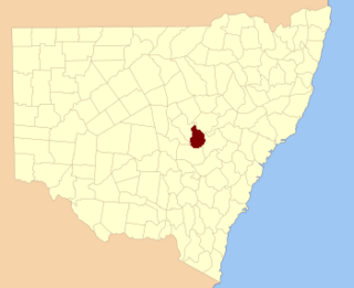
Kennedy County is one of the 141 Cadastral divisions of New South Wales. It is located to the west of the Bogan River in the area around Tottenham and Tullamore.

Mootwingee County Cadastral in New South Wales, Australia

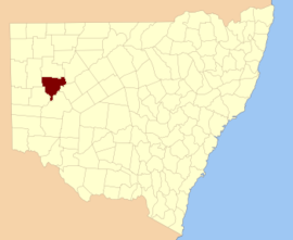
Mootwingee County, New South Wales is one of the 141 Cadastral divisions of New South Wales.

Oxley County Cadastral in New South Wales, Australia

Oxley County, New South Wales is one of the 141 Cadastral divisions of New South Wales. It is located between the Bogan River on the west, and the Macquarie River on the east. This is the area approximately between Warren and Nyngan.

Cobrabald River

Cobrabald River, a mostly perennial river that is part of the Namoi catchment within the Murray–Darling basin, is located in the Northern Tablelands district of New South Wales, Australia.

Currawang Cadastral in New South Wales, Australia

Currawang is a locality in the Queanbeyan–Palerang Regional Council, on the edges of Upper Lachlan Shire and Goulburn-Mulwaree Council, in New South Wales, Australia. It is located to the north of Lake George. It shares its name with the Currawang Parish of Argyle County, in which it is located. This was formerly known as the parish of Currowang. Both names derive from an Aboriginal word for the spearwood tree.

Berthong Creek

The Berthong Creek, a mostly–perennial river that is part of the Lachlan sub-catchment of the Murrumbidgee catchment within the Murray–Darling basin, is located in the South West Slopes, and Riverina regions of New South Wales, Australia. The Berthong Creek is only connected to the Murray Darling basin when the Bland Creek, the Lachlan and Murrumbidgee Rivers are in flood.

Bulla Creek

The Bulla Creek, a mostly–perennial river that is part of the Lachlan sub-catchment of the Murrumbidgee catchment within the Murray–Darling basin, is located in the South West Slopes region of New South Wales, Australia. The Bulla Creek is only connected to the Murray Darling basin when the Bland Creek and both the Lachlan and Murrumbidgee Rivers are in flood.

References

  1. "Young". Geographical Names Register (GNR) of NSW. Geographical Names Board of New South Wales . Retrieved 11 August 2013. OOjs UI icon edit-ltr-progressive.svg